Category Archives: National Landmark

National landmark or historical place

Yellowstone NP part 3 June 24, 2020

Yellowstone is such an amazing national park. Whatever your interest, it has something for everyone. Geysers, hot springs, animals galore, gorgeous scenery and waterfalls. On our third day into the park we focused on waterfalls. IMG_20200627_105328

Yellowstone has a grand canyon. Not as huge or magnificent as THE Grand Canyon, but still fabulous and beautiful with not one but two magnificent waterfalls. The Grand Canyon of the Yellowstone River was created from a lava flow 484,000 years ago.  It is mainly made of rhyolite rock.  Past and current hydrothermal activity weakened and altered the rock, making it softer.  The Yellowstone River eroded these weakened rocks to deepen and widen the canyon, a process continuing today.  The canyon is twenty miles long, more than a thousand feet deep, and between 1,500 and 4,000 feet wide with two waterfalls. IMG_20200624_100902

One end of the canyon begins at the 308 foot tall Lower Falls which may have formed because the river flows over volcanic rock more resistant to erosion than rocks downstream.  The same is true for the 109 foot Upper Falls. IMG_20200624_100707IMG_20200624_110656

When we were here five years ago we hiked several trails around the falls and one strenuous hike with 13 switchbacks that took us to the top of the falls. This time the trail was closed due to the pandemic. Just one of many things still closed throughout the park. But we still had plenty to see and do to keep us busy. IMG_20200624_105630IMG_20200624_110752

Along with visiting the canyon we drove through Hayden Valley where we saw plenty more bison, some elk and a bear. IMG_20200624_141025IMG_20200624_142401

We didn’t get a picture of this bear since he was too far away to get a clear picture. IMG_20200624_123955IMG_20200624_123747

This area took us along Yellowstone Lake (elevation 7,733 feet) with stunning views of water with snow capped mountains in the distance. IMG_20200624_124355

We stopped at an area with rapids where we actually talked with a park ranger, our only real interaction with a ranger all week. He told us if we looked closely we could see fish. This time of year is when the water flows at its highest. The fish were waiting because they knew as the water flow decreased during the hotter summer months, it would be time to swim back to the lake. We enjoyed some time there, watching the fish near the surface occasionally jumping out of the water. Too fast to catch with a camera! MVIMG_20200624_132732IMG_20200624_132824

This hill side is called Roaring Mountain. On the hill side if you zoom in you can see two active steam vents. IMG_20200624_150410IMG_20200624_150855

We stopped at a mud volcano area with a nice boardwalk around the hot springs. There were plenty of signs warning people to stay on the boardwalk because thermal areas have a thin crust above boiling hot springs and scalding mud. Some of the pools are acidic enough to burn through boots! More than twenty people have been scalded to death and hundreds more badly burned or scarred because they left the boardwalks. Imagine our surprise when we saw three bison very close by as we reached the halfway point around the boardwalk. A ranger was there and stopped people from continuing to get close to the bison out of fear of them becoming agitated.  We saw this happen on our first day when a lady with a camera got too close, and we were glad of the strong fence.  One was rubbing against a small tree, evidently trying to rub off the last of his winter coat. IMG_20200624_135718

Another was drinking water from a small pool of muddy water, yuck!! IMG_20200624_135544

The third was actually inside a mud pot area and we wondered how hot the ground was on his hooves. Eventually another ranger came with yellow caution tape and stopped anyone from entering that area of the boardwalk.  IMG_20200624_135520

The elevation drops significantly by a waterfall on the Gardner River as we travel to Mammoth Hot Springs and eventually to the North Entrance at 5,314 feet. MVIMG_20200624_153847

Near this waterfall we saw a lone Dall sheep high on the hillside feeding on the grass. He was so high up it was difficult to get a clear picture. IMG_20200624_154120IMG_20200624_154219

The next day Bill took a half day white water rafting trip on the Yellowstone River with the Yellowstone River Raft Company located in Gardiner MT.  IMG_20200627_111804MVIMG_20200626_095218

They went right behind our RV and I was waiting to take his picture. IMG_20200626_103952IMG_20200626_104012~2

The river was running with a good volume/flow of 10,000 cubic feet per second. He had a great time/ride and was glad to add the Yellowstone River to the lists of rivers he has rafted. IMG_6614~2IMG_0815~2IMG_6604

Next up: Our last day in Yellowstone NP


Yellowstone NP part 1 June 20, 2020

We looked forward to visiting Yellowstone National Park again this summer. We were last there in 2015. We left Idaho Falls and traveled to Island Park, Idaho for a two night stay. Along the way we could see the beautiful Grand Tetons mountain range in the distance. IMG_20200620_120115MVIMG_20200620_120131

Island Park, located just outside the west entrance of Yellowstone, was the perfect place to stay to visit the Old Faithful geyser. 

Established in 1872, Yellowstone is the world’s first national park.  Of the 2.2 million acres, 80% is forest, 15% is grassland and 5% is water.  Ninety-six percent of the park is in Wyoming with 3% in Montana and 1% in Idaho.

Yellowstone is HUGE with:

  • five entrances into the park
  • ten visitor or information centers
  • three medical clinics
  • six gas stations
  • seven general stores
  • five hotels or lodges
  • twelve campgrounds of various sizes
  • and numerous restaurants and gift shops

But it was a very different Yellowstone than what we visited five years ago. The Visitors Centers were all closed. We always really enjoy the movies about the park shown at the Visitors Centers and we were disappointed not to see them again. With the Visitors Centers closed, access to Rangers and information on the park was very difficult. There were no informative Ranger talks and hikes. Restaurants were closed leaving tourists scrambling for food at the few general stores open. Most lodges and hotels were closed. Crowds were down but there were still plenty of people enjoying the park, some with masks and many without. In spite of it all, we were very grateful the park was open for us to visit and enjoy. 

Unfortunately the day we chose to visit Old Faithful was cold and windy with rain showers. The cold and high humidity gave us a very different perspective at the geysers. IMG_20200621_103745

This was most noticeable at the Grand Prismatic Spring. The wind was blowing so hard and there was so much hot steam as we walked along the boardwalk, we were not able to see the beauty of the hot spring. We noticed that some Bison had stomped around before we got here. IMG_20200621_101446

As we walked along the boardwalk we were enveloped in hot blowing steam, which quickly would fog your glasses. Here are pictures taken today IMG_20200621_095725IMG_20200621_101001IMG_20200621_101020IMG_20200621_101253IMG_20200621_102650IMG_20200621_101436

followed by pictures taken five years ago on a much better weather day. IMG_20200621_101706IMG_0555IMG_0560

It is always a thrill to see Old Faithful, the most popular and famous attraction in Yellowstone. It is rightfully named because it faithfully erupts every 60 to 90 minutes, spewing 8,400 gallons of steaming hot water up to 180 feet into the air. It is one of the most predictable geysers on earth. We timed our visit just right so we only had a ten minute wait for the next eruption. MVIMG_20200621_105605IMG_20200621_105910IMG_20200621_105741IMG_20200621_110637

Yellowstone is home to more geysers than any other place on earth and is one of the world’s most active geothermal areas.  Within the park are hundreds of geysers, hot springs, mud pots and steam vents.  This is because the park sits atop an enormous “supervolcano” and the immense heat from the underground magma powers the geysers.  The volcano last erupted 640,000 years ago and shows no signs of erupting anytime soon. Water from precipitation seeps into the ground, meeting the superheated earth near the underground magma chamber.  Tremendous pressure builds up until the water is forced back to the surface.  Some geysers like Old Faithful have their own underground “plumbing systems” and erupt at predictable intervals.  Other geysers share plumbing “pipes” with adjacent geysers and erupt more sporadically.

Yellowstone has approximately 700 to 3,000 earthquakes a year, most not felt. IMG_20200621_140157IMG_20200621_140245IMG_20200621_141824

After seeing Old Faithful show off, we explored some more of this side of the park. IMG_20200621_134327IMG_20200621_134054IMG_20200621_134439

We stopped by beautiful Kepler Cascades IMG_20200621_131058

and then impressive Gibbon Falls. IMG_20200621_145509

We also stopped at the Continental Divide and had lunch. IMG_20200621_125739

Despite the weather, a great first day in the park! 

Next up: Yellowstone part 2: Bison, pronghorn sheep and bears, oh my! 

Brigham City, UT May 26, 2020

Leaving Provo we drove 100 miles north to Brigham City, Utah pop 19,000. Brigham City is much smaller than Provo or Salt Lake City and we enjoyed the small town feeling of the city. Brigham City was named in 1877 for Brigham Young who delivered his last public address there in 1877.  IMG_20200531_121100

Bill and I felt comfortable enough there to both get haircuts which we really needed. 

We were there for a week and enjoyed touring the area. One day we drove 32 miles to Corinne where we visited the Golden Spike National Historic Site.  IMG_20200527_124309IMG_20200527_125511It was here at Promontory Summit that the Union Pacific (UP) and Central Pacific (CP) rails converged to form the nation’s first transcontinental railroad on May 10, 1869. A golden spike and three other precious metal spikes were placed to commemorate the occasion. Those spikes were then removed and replaced by a regular wooden tie secured to the rail with iron spikes to officially complete the railroad.  IMG_20200527_131556~2

It had taken six million spikes and six years of hard work to complete the railroad. At times distracted by the Civil War, facing rough terrain and raids by Sioux and Cheyenne, they managed to get the job completed. Eight flatcars of material was needed for each mile of track and every rail, spike and locomotive had to be shipped 15,000 miles around Cape Horn. What a logistical nightmare! With the help of unemployed Irish, German and Italian immigrants, Civil War veterans, ex slaves and Native Americans, a total of 8,000 to 10,000 workers laid two to five miles of track a day on flat land. 

The Pacific Railroad Act of 1862 mandated that only American made iron could be used. The demand for iron for building the railroad helped boost the domestic economy. By the 1870’s the iron rail was replaced with sturdy steel rail which had become more widely available after the Civil War. 

Congress authorized Central Pacific to build a railroad eastward from Sacramento and at the same time chartered the Union Pacific in New York to go westward. Due to a lack of precise instructions from Congress as to where the rails should meet and financial rewards for building the railroad, the two railroads prepared rail-beds parallel to each other for 250 miles.  IMG_20200527_130738IMG_20200527_130845

Each railroad received loan subsidies of $16,000 to $48,000 per mile depending on the difficulty of the terrain. Once it was determined the rail-beds were parallel, the railroads were ordered to unite the track. No railroad tracks were ever laid on the parallel beds. Promontory Summit was then chosen as the point to join the tracks. IMG_20200527_140209IMG_20200527_140231big trestle~2

Central Pacific (CP) laid 690 miles of track and Union Pacific (UP) 1,086 miles of track across desert, rivers and mountains to unite the east and west coast with 1,776 miles of rail. This brought big changes to the country. People were now able to travel cross country, there were new opportunities for commerce and it opened up settlement in California, Colorado, Nebraska, Nevada, Wyoming and Utah. What had once been a six month journey was now just a week. The prairie schooner was replaced by a railroad coach with all its comforts.  

Legislation also called for a telegraph line to be strung along the transcontinental route to bring in a new era of instant communication from coast to coast. When word went out by telegraph in May, 1869 that the railroad and telegraph were completed, Americans celebrated in city after city with church bells ringing, cannons firing, parades, prayers, and singing of the “Star-Spangled Banner”. IMG_20200527_131958

Due to the pandemic we were disappointed that the Visitors Center and theater was closed. The working replicas of the 1869 steam locomotives named “119” (Union Pacific”and “Jupiter” (Central Pacific) were in storage and not in view. Last year on the 150th anniversary they were placed nose to nose.

We were able to drive the two mile East Auto tour which followed old railroad grades and showed the parallel grading completed by the railroad companies.  IMG_20200527_135216IMG_20200527_135001~2IMG_20200527_135011~2

We saw the Chinese Arch formed by waves crashing against the ancient shore 300 million years ago which eroded the rock. It is believed it was given the name Chinese Arch in recognition of the presence and contribution made by the Chinese who worked on the railroad. IMG_20200527_135415~2

On the way home we stopped by the Northrop Grumman Innovation Systems Rocket Garden. The garden displays rockets and missiles built from the 1950’s to the 2000’s. IMG_20200527_144045~2

One of the rockets is a shuttle booster that took the spaceship with its astronauts to a speed of 17,4000 miles per second. There is also a Minuteman intercontinental ballistic missile, a Maverick air to ground missile designed to be launched from Black Hawk helicopters and an Atlas rocket motor just to name a few of the 39 exhibits.  IMG_20200527_143411IMG_20200527_142248

Patriot missiles are a long-range, all-altitude, all-weather air defence system to counter tactical ballistic missiles, cruise missiles and advanced aircraft.  IMG_20200527_143503~2

On another day we drove over an hour on the Logan Canyon National Scenic Byway to beautiful Bear Lake. Often called “The Caribbean of the Rockies” because of its intense turquoise blue water, the color of the lake comes from limestone that has calcium in it. IMG_20200531_141230

The calcium, like millions of microscopic mirrors, reflects light from the sky. Bear Lake changes color depending on the weather, wind and time of day. It is believed Bear Lake formed 455,000 years ago. From 1350-1850, thousands of years Native Americans such as the Shoshoni, Ute and Bannock tribes lived in Bear Valley. Bear Lake was discovered in 1812 by trappers returning home from Astori, Oregon. The valley became an important fur trade center. Most of the settlers came from Britain. IMG_20200531_141610IMG_20200531_143951

We enjoyed driving around part of Bear Lake on the Oregon Trail Bear Lake Scenic Byway. Bear Lake is so big it is located in both Utah and Idaho. IMG_20200531_160505IMG_20200531_150836IMG_20200531_153547IMG_20200531_153617

After six weeks in beautiful Utah it is time to move on. IMG_20200531_172629

Next up: Twin Falls, Idaho

Big Bend NP Texas Oct 25, 2019

We left cold, windy Marfa and headed to Big Bend National Park located in southwestern Texas along the Rio Grande River and the boundary with Mexico. It is a long drive to Big Bend, one of the most remote and least visited national parks in the contiguous United States.  The nearest city is 75 miles away and there is no cell phone service and very limited WiFi which is only available at the park visitors centers. Conveniently there are two gas stations located in the park. IMG_20191026_130448

Big Bend gets its name from the 90 degree turn in the Rio Grande River near the southern tip of the park. The river is the natural border between the United States and Mexico which creates some complicated security issues for the Border Patrol in the area. We saw border patrol vehicles throughout the park.

We had a wide range of temperatures the week we were there with daytime highs ranging from a high of 97 to a high of only 67 degrees in a matter of days. A cold front blew in near the end of our seven day stay and we had winds of 25 to 35 mph for almost 24 hours. IMG_20191026_165109IMG_20191026_151058IMG_20191029_171452IMG_20191029_171521

One striking thing about this park is how big the park is and how far you have to drive to get from one side to the other. To get from the east side of the park to the west side is over fifty miles and takes an hour and a half. Because of the extreme heat in the summer, the high season here begins Nov 15th and runs to April 15th. The park is so large it has five visitors centers but only two were open this time of year. The park has a limited number of paved roads and many gravel and dirt roads. We learned from a park ranger that since they had just finished their rainy season, any unpaved roads were in too bad a shape to drive our Honda CRV. This was disappointing because it limited the amount of park we could explore. IMG_20191026_161551

The first day we visited Panther Junction Visitors Center and saw the park movie. IMG_20191026_13435120191026_155109

IMG_20191026_154323

Our First Texas View Of The Rio Grande River West OF The Park

During our time in the park we saw many roadrunner and sharp eyed Bill caught sight of a javelina along the side of the road. He managed to get a picture before it got spooked and ran off. We learned from the park movie that javelinas have a snout like a pig and smell like a skunk. IMG_20191027_164932

One day we drove to Santa Elena Canyon to do a hike into the canyon. When we arrived we discovered that the river bed that is normally dried up and must be crossed to reach the trail, was now covered in knee deep water. We seriously considered taking off our shoes and socks and walking across until we heard from others that there was thick deep mud we would have to plow through. We watched other people cross and when they emerged from the sludge it looked like they had on gray knee socks from the mud. No thanks. IMG_20191027_135815

We were content looking at the canyon from a distance. This canyon, like others in the park, had nearly vertical walls made primarily of limestone. IMG_20191027_135527IMG_20191027_140520

We drove the Ross Maxwell Scenic Drive enjoying the geologic splendor of the park. IMG_20191027_143838IMG_20191027_153213IMG_20191027_143435

We stopped by the Fossil Discovery Exhibit where we learned about the plants and animals that lived here millions of years ago. At one time a shallow sea covered Big Bend and much of Texas, leaving behind fossils of fish, sharks and swimming reptiles. As the water receded the area was inhabited by dinosaurs and giant alligators. IMG_20191026_171802IMG_20191026_172421

Over the years many fossils and bones have been discovered in the park. IMG_20191026_172516

Another day we drove an hour from our campground which was located in the park to the Chisos Basin section. To get to this area the car climbed two thousand feet above the desert floor. Here there is a lodge and the other visitors center which was open. We took a nice walk on a paved trail to the “Window View” with beautiful views of mountain vistas and the valley basin below. 20191029_15312520191029_15232920191029_15330420191029_163339

Near the end of our stay we drove to the hot springs section of the park. In the early 1900’s people began to come to the area to bathe in the hot springs. It was believed that the mineral springs had healing powers. The owner of the land recognized the potential monetary value of the 105 degree mineral springs and built a bathhouse and desert health resort. By 1927 the availability of automobiles and improved roads meant even more people visiting and so a store, post office and motel were added. In 1942 the landowner sold the land to the state of Texas. In 1944 Texas gave the land to the United States for a national park. 20191026_135024

The unpaved gravel road was very narrow and a little tricky to navigate but the Ranger assured us it was the one unpaved road still accessible. We parked and began the short trail to the springs. IMG_20191030_144448

We could see the remains of some of the buildings from this once prosperous community. IMG_20191030_142513

We arrived at the hot springs where three older women had arrived just ahead of us. They nonchalantly glanced at us and then proceeded to completely strip off their clothes and walk naked down into the springs. Any desire to go down and dip our toes in disappeared at that point. We didn’t stay long. IMG_20191030_144836_MP

Next up we drove to the Boquillas Canyon overlook with more spectacular canyon and Rio Grande river views. IMG_20191030_154528

Across the river, we could see the Mexican town of Boquillas. There is a border water crossing there that is open several times a week. 

We enjoyed our time in Big Bend National Park. It had been on Bill’s bucket list for several years. We probably would not return mainly because it is so remote and takes so much driving time to get there.

On the way back west in one small Texas town a crowd of people had stopped along the train tracks, some with cameras on tripods. We wondered what they were waiting for and then Bill remembered seeing on the El Paso TV news about the 150th anniversary of the Union Pacific’s Big Boy No. 4014, the world’s largest steam locomotive. It was doing a “Great Race Across the Southwest” run with stops in El Paso, San Antonio and Houston. We stopped along the roadside and snapped a few pictures as it went by. Great timing! IMG_20191101_14322320191101_143439

This ends our summer travels which took us to Monument Valley and into Colorado before making our way back down to New Mexico and Texas. 

Next up we are headed back west to spend some time in Tucson and Casa Grande before spending the winter once again in Yuma, Arizona. 

New Mexico & Texas, OCT 2019

After our visit to the Trinity Site we left Socorro and headed to Caballo Lake, New Mexico. We stayed a week at a small RV park owned by an 82 year old lady. It was one of the cleanest parks we have ever stayed at. Every afternoon she had Happy Hour on her covered veranda for everyone. She furnished snacks and each person brought something to drink. By snacks I am talking about meatballs in a delicious sauce, cheese and crackers, chips and guacamole, watermelon, cookies and cakes. Every day! After talking with other people we realized many of them come back for a visit year after year. I think these Happy Hours give the owner some social interaction and also enable everyone in the park to get to know each other. We can see why people come back year after year. 

Next up was Las Cruces, our last stop in New Mexico. When we arrived we unhooked the tow car and discovered the battery was dead. Using the RV, Bill was able to jumpstart the car. We took it to Walmart and since the battery was bad and still under warranty, they gave us another one. But we also learned that the alternator was bad. After learning it would be over $500 plus labor at the Las Cruces Honda dealer, we hired the Walmart mechanic to come to the RV park when he got off work and replace the alternator. For a total of $280 he picked up a new alternator at Autozone, took out the old one and put the new one in. 

After seven weeks, our time in New Mexico came to an end as we crossed into Texas. We took the bypass around the very congested El Paso and after overnighting in Van Horn, we stopped in Marfa, Texas for a three night stay. 

Our reason for spending three nights in Marfa was to visit three nearby places we wanted to visit. 

First up was the Fort Davis National Historic Site. Named after Secretary of War Jefferson Davis, it is one of the best remaining examples of a frontier military post and the role the military played in the settlement and development of the western frontier. IMG_20191023_102128IMG_20191023_102212

From 1854 until 1891 troops stationed at Fort Davis protected pioneers, freighters, mail coaches and travelers on the San Antonio-El Paso Road. The troops spent much of their time protecting area travelers from attack by Comanches and Apaches. During the Civil War the fort was first occupied by Confederate troops in the spring of 1861 until the summer of 1862 when Union forces took possession back. After the war ended the fort once again protected travelers on the San Antonio-El Paso Road from Indian attack. By June, 1891 the fort had outlived its usefulness and was abandoned. It became a National Historic Site in 1963. IMG_20191023_110253
During the summer months they have more activities and living history programs, but on this late October mid week visit things were very quiet. After watching a film at the Visitors Center, we enjoyed walking through the buildings that were open including the enlisted men’s barracks, the commissary, Officer’s kitchen, the post hospital and Officer’s Quarters.

IMG_20191023_111214

Enlisted Barracks

IMG_20191023_114511

Hospital Beds

IMG_20191023_114807

Operating Table

20191023_120148

Officer Housing For Two Families

In the kitchen there was a woman in period costume making chili, corn bread and banana bread over a wood burning stove. She was a little flustered because her wood fire had gone out and she had promised to provide lunch to the staff at the Visitors Center. 20191023_113516

The second attraction was the McDonald Observatory located 45 minutes from Marfa. The observatory is part of the University of Texas at Austin. IMG_20191023_124121

We had booked online a two and a half tour of the observatory. Before our tour started we looked around the Visitors Center and saw a movie. Our tour was a nice small group of fourteen and we had a fantastic tour guide. A former public school science teacher, it was quite obvious that she loves her job. After talking about the sun and showing us a live picture of the sun from one of the telescopes, we all boarded a shuttle bus to tour two telescopes. 20191023_145920

The first telescope we visited was located on Mt Locke which at 6,790 feet is the highest point on the Texas highway system. The view from there was beautiful. The Harlan J. Smith Telescope was completed in 1968 and supported NASA. This telescope’s mirror is 2.7 meters or 107 inches. IMG_20191023_162138IMG_20191023_153918

Our guide told us and showed us about how the telescope and dome moved. She talked about the mirror monthly maintenance which involves cleaning with dry ice. 

We all boarded the bus again to the summit of Mt Fowlkes (6,660 ft) to see the Hobby-Eberly Telescope dedicated in 1997. This telescope, after upgrades, is now tied with another telescope as the second largest optical telescope in the world (11-meter or 433-inch). IMG_20191023_16322020191023_163404IMG_20191023_165500
The mirror looks like a honeycomb made up of 91 hexagonal mirrors.

IMG_20191023_163604

Hexagonal Mirrors – The Curved Bars Are Reflections

IMG_20191023_165555

Our guide was so enthusiastic and eager to answer questions, our tour ended up lasting three hours instead of two and a half. Amazing to get such an interesting and informative tour for $7 (senior rate). IMG_20191023_165224

Mark you calendars – here is the time and places for the next Total Solar Eclipse. IMG_20191023_144009

Marfa is an interesting tiny Texas town. Most of the visitors, like us, pass through here on their way to Big Bend National Park. It has a very pretty courthouse and some interesting sounding restaurants, unfortunately for us most are only open on the weekend. IMG_20191023_095732

We did read about a Mediterranean food truck which had excellent reviews. Bill got a falafel called a Marfalafel named after the town. While Bill enjoys Mediterranean food, it was his first falafel and probably his last.  20191024_123122IMG_20191024_123158

Marfa is also known as having a phenomenon known as the Marfa ghost lights.  The town built a large viewing area outside of town with bathroom facilities and benches. One evening, just to say we did it, we drove to the viewing area and spent about thirty minutes looking for the lights. Other people there were convinced they saw the Marfa lights. We didn’t see anything that couldn’t be explained as man made such as lights from cars in the distance or radio towers. 
IMG_20191023_180434
Our last day in Marfa a cold front blew in. We had wind gusts up to 30 mph and that night a low of 27.  Time to move on! 

Next stop: Big Bend National Park, Texas

New Mexico, Sept 2019

Santa Fe RV Rally

We have had an enjoyable slow paced fall. In early September we attended a Family Motor Coach Association – amateur radio rally in Santa Fe, New Mexico. It was an enjoyable four days with eleven couples, a few we had met before and others for the first time. 20190901_18385320190901_184054

It was fun to see all the RVs with their antennas in the campground. IMG_20190903_103553

Santa Fe is a pretty little capital city. This was our third visit to the area. 

Albuquerque and Hamfest

Next up was a month in Albuquerque. We spent the time getting some medical appointments taken care of and working on travel plans for the rest of 2019 and 2020. IMG_20190918_140903

While we were here the Albuquerque amateur radio group had a three day Hamfest which we attended. I studied hard and was able to pass a test to update my amateur radio license from Technician to General operator class. Bill already has an Extra license, the highest level available. 20190921_155647

Trinity Site

Leaving Albuquerque we traveled south to Socorro, New Mexico for a four night stay. Our main reason for stopping here was to visit the nearby Trinity Site. The site is only open twice a year, the first Saturday in April and October. IMG_5192

We have wanted to visit this historic site for several years and this is the first time we have been in New Mexico at the right time. They only open the site twice a year because the site is located on the United States Army White Sands Missile Range where they often conduct missile tests. White Sands Missile Range is one of the most sophisticated test facilities in the world. IMG_5198

Since the site is only open twice a year, it can attract quite a few visitors. I had read that the site opens at 8:00 A.M. but that cars start lining up to get in as early as 6:30 A.M. Since we had an hour drive we left at 5:45 in darkness and heavy fog. It was so foggy we could hardly see to drive.  But even with the fog we arrived at 7:00 and there were about 25 cars in line in front of us. Instead of 8:00 they didn’t open the gate until 8:30 for reasons unknown. We had to pass through security and show our driver’s licenses and confirm we had no weapons or firearms. IMG_5212

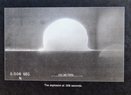
The Trinity Site is where the first atomic bomb was tested early in the morning of July 16, 1945.  The 51,500 acre area where the 19 kiloton explosion occurred was designated a national historic landmark in 1975.  Several potential sites in California, Texas, New Mexico and Colorado were considered but this site was ultimately selected because it was already controlled by the government. It was part of the Alamogordo Bombing and Gunnery Range which had been established in 1942.  The area was secluded which provided secrecy and safety and was also close to Los Alamos where the atomic bomb was designed and built. 

The Trinity Site area where the bomb was placed and exploded is called “Ground Zero”.  It is reached by walking a third of a mile from the parking lot. IMG_5213IMG_5214IMG_5216IMG_5218IMG_5228

An obelisk made of lava stone marks the actual spot. IMG_5226IMG_5229IMG_5233IMG_5225IMG_5222

IMG_5227

This Is What Is Left Of One OF The Tower Legs


They had a replica of Fat Man, the bomb that was dropped on Nagasaki, Japan in 1945. This is the type of bomb tested at the Trinity Site. IMG_5234

We also took a bus from the parking lot to Schmidt/McDonald Ranch House. IMG_5208IMG_5204

This is where the plutonium core to the bomb, about the size of a briefcase, was assembled. IMG_5200

I was interested in the radiation levels at the Trinity Site. They say the radiation levels are very low with the maximum levels about ten times greater than the region’s natural background radiation. Many places on earth are naturally more radioactive than the Trinity Site. A one hour visit to the site will result in a whole body exposure of one half to one millirem. To put this in perspective, Americans receive an average of 620 millirem every year from natural and medical sources. A sequence of pictures taken that day were on display. IMG_5230IMG_5231IMG_5232

As we were leaving the Trinity Site we passed protesters from New Mexico.  They claim families in the area were affected by the testing in 1945 and never received any restitution. We were told the protesters gather every year. 

National Radio Astronomy Observatory – Very Large Array

After stopping home for lunch we decided to make a full day of sightseeing and drove up to see the Very Large Array. IMG_5236IMG_5239

They were having free admission since it was the first Saturday in October. The Very Large Array is one of the world’s premier astronomical radio observatories. It features 27 radio antennas in a Y shaped configuration. Each antenna is 82 feet in diameter and weighs 230 tons. Bill took a 50 minute guided tour of the facility and really enjoyed learning about these radio antennas. IMG_5238IMG_5243IMG_5244IMG_5237

The individual signals are merged to one picture and then colored to add perspective. Here is an example of one picture made from radio wave emissions from outer space. dwarf galaxy UGC5288 gas_large-1006x1024

Here is what radio waves are transmitted when pointed at Saturn. IMG_5240

The Next Generation Very Large Array is underway and will start construction of two hundred plus radio antennas to improve the sensitivity ten times. IMG_5248IMG_5245IMG_5246

We have just a couple more stops in New Mexico. 

Great Sand Dunes NP & Preserve, CO AUG 16, 2019

We enjoyed our time in Dillon and hated to leave the cool mountain temperatures, but it was time to move south. The journey was not a piece of cake since we had to cross over three mountain passes including Poncha Pass, Trout Creek Pass and Hoosier Pass which was at an elevation of 11,539 and at the Continental Divide. IMG_5129IMG_513120190816_120509IMG_5133

Our destination was Great Sands National Park and Preserve. This national park is located in the middle of nowhere. We had very limited Verizon but Bill was able to improve the signal with our cell phone booster. IMG_5134

Open this image up so you can zoom into the big picture.great sand dunes np

We stayed at a private campground right outside the park entrance with great views of the sand dunes and the Sangre de Cristo Mountains in the distance. IMG_5157IMG_20190819_114420IMG_20190819_113133

The park was first named a National Monument in 1932 and was designated a National Park in 2004. The park is comprised of 107,342 acres with the preserve protecting an additional 41,686 acres. The dunes cover thirty square miles. We stopped by the Visitors Center and saw an interesting movie about the park. IMG_20190820_112158

These sand dunes are the highest in North America both in height and elevation. Some of the dunes are up to 750 feet tall. Who would have thought the highest sand dunes in North America would be found more than a thousand miles from any ocean beach?? The sand dunes have been building and shifting for eons due to the San Luis Valley’s unique wind patterns which trapped the sand along the west face of the Sangre de Cristo Mountain Range. 20190817_143021

The park guide basically says most of the sand comes from erosion of the San Juan Mountains over 65 miles to the west where the sand grains are shattered by freezing and thawing and then tumbled by winds and streams. Larger grains of sand and pebbles also come from the Sangre de Cristo Mountains. Sand and sediment from both mountain ranges washed into a huge lake that once covered the valley floor. As the lake was reduced, southwesterly winds bounced the sand grains against the Sangre de Cristo Mountains where they were trapped by the tall mountain ranges. Northwesterly storm winds blast through mountain passes piling the sand back on itself which creates North America’s tallest sand dunes.

Each spring the Medano and Sand Creeks carry snow melt  through the park at the base of the dunes. The water recycles sand and provide a lifeline for the plants and animals in the park. In late spring and early summer the creeks are swollen and we saw pictures of children swimming and playing in the water. Now, in late summer, the creeks are almost dried up. You can see in the pictures wet looking places where the creeks are almost dry. But still enough water to get our feet wet. It is all so amazing! IMG_5178IMG_514220190817_144811IMG_5144

There were people climbing up the dunes and the park rented sleds and sandboards for sliding down. But with sand temperatures up to 150 degrees in the summer, we passed on hiking the dunes. The dunes were very hot and absolutely no shade. 

There were some fabulous sunsets from our campsite. Hard to decide which ones to include! These were taken during two sunsets. IMG_5147IMG_5161IMG_5169IMG_5185a

These two pictures occurred during sunset facing north over the dunes. IMG_5182aIMG_5191a

While this was a fascinating national park and we are really glad we visited, it is very remote and probably not a park we would return to in the future. 

Next up our last stop in Colorado 

Dillon, CO AUG 13, 2019

This blog posting is as much about the journey as it is about the destination. 20190813_105039

We left too hot Grand Junction and headed east to cooler temperatures. Following the Colorado River we saw amazing rock formations that are much like you would see in New Mexico and Utah.  20190813_10544220190813_10574820190813_11110120190813_11121620190813_11181020190813_111931

Along the roadside every quarter to half a mile we saw wildlife ramps that had been constructed so animals could easily escape the busy highway and not get trapped. 20190813_11225120190813_115634

People were out enjoying the river by fishing, kayaking or in some of the more rocky areas whitewater rafting. 20190813_11584820190813_11585220190813_12090820190813_123901

We drove through two tunnels constructed in the sides of mountains. It is always amazing to think of all the hard labor that goes into constructing these tunnels. 20190813_12093020190813_12430020190813_124310

We passed by the city of Vail, elevation 8,150 feet.  Since Grand Junction had an elevation of 4,600, we were climbing higher and hopefully to cooler temperatures. We noticed all the condominiums, homes and lodges built along the mountainside in this popular ski resort. Visible were the ski slopes, now a beautiful green instead of white with snow. 20190813_13152620190813_13340220190813_13360820190813_13371920190813_13375520190813_133825

Up, up, up we climbed on I-70 until we finally reached Vail Pass Summit at 10,603 feet. 20190813_135625At this point we started to drop down a little to our destination of Dillon, Colorado, elevation 9,087.  We stayed at White River National Forest campground just outside of town for three nights. We were so happy to have cooler temperatures. Our first night the temperature got down to 37 degrees with daily highs in the low 70’s. Perfect! IMG_20190815_163835

The towns of Dillon, Silverthorne and Frisco all run together and are ski resorts with tourism as their main economy. It is a thriving, bustling area with many big name stores and restaurants. Since it was busy in August, I can only imagine what it is like in the winter during ski season. We were amazed at the homes perched right on the edge of the mountains. IMG_511720190813_142303

Dillon Dam and Reservoir, a large freshwater reservoir, has a 25 mile shoreline with a walking /biking path that appeared to be heavily used. It is a reservoir for the city of Denver. The dam diverts water through a 23.3 mile tunnel under the Continental Divide to Denver. During the Great Depression when many Dillon people could not pay their property taxes, the Denver Water Board acquired most of the water rights in the area. In 1956 the Denver Water Board told the remaining citizens of Dillon that a dam was going to be built and they had until 1961 to sell their property and leave. The dam construction began in 1961 and was completed by 1963. The Denver Water Board set aside 172 acres for the new town of Dillon. The citizens and businesses were responsible for moving their own homes and structures. Many chose not to and the population shrank to 57. Today Dillon’s population is 904 not counting the nearby towns of Silverthorne and Frisco. With that sad history, it is so nice to see the thriving community today. 20190813_14222620190813_141751IMG_5115IMG_5127

One day we drove the car on Interstate 70 to the nearby Eisenhower – Edwin C. Johnson Memorial Tunnel which at 11,158 feet is one of the highest vehicle tunnels in the world. It is also the longest mountain tunnel and highest point in the interstate highway system. It is a two bore four lane vehicular tunnel under the Continental Divide in the Rocky Mountains. We first headed eastbound through the tunnel named for Edwin C. Johnson the  Colorado former governor and state senator. We then turned around and drove through the westbound bore which is named the Eisenhower Tunnel after President Dwight Eisenhower, for whom the Interstate System is also named. The Eisenhower Tunnel was built first and took five years to be be completed in 1973. The Johnson Tunnel took four years, was completed in 1979 and was one of the last major pieces of the country’s interstate system. Each tunnel is just shy of 1.7 miles long. The tunnels are sloped at 1.64% grade and have a steep approach of 7% grade on one side and 6% on the other. The tunnel has a clearance of 13 feet 11 inches. In 2012 approximately 28,000 vehicles passed through the tunnel bores each day, or 10.7 million vehicles per year. During construction of each tunnel bore, there were three fatalities in the Eisenhower bore and four in the Johnson tunnel bore. IMG_5088IMG_5090IMG_5093IMG_5096

Next up: Great Sand Dunes National Park and Preserve, CO

Grand Junction, CO AUG 9, 2019

We left Black Canyon of the Gunnison National Park and headed north to Grand Junction, Colorado, pop 59,000. We dropped from 9,400 ft to 4,600 ft and boy did it get hot!! During our time in Grand Junction the temperatures hovered in the low to mid 90’s. We sure did miss those mountain temperatures! 

On the way to Grand Junction we passed interesting sand formations. 20190808_12342420190808_12544820190808_12552020190808_125525

We stayed five nights at the James Robb State Park, a very nice Colorado state park, but there was absolutely no shade and it was HOT! 

One day we crossed the Colorado River and made the short drive to the Colorado National Monument, designated a National Monument in 1911. IMG_20190812_154419IMG_5022

The Monument is 32 square miles of rugged canyon terrain with towering red sandstone monoliths that rise 2,000 feet above the Grand Valley. The colors come from the minerals in the rocks as well as the kinds of lichens and chemical compounds that coat the rocks. IMG_5035

We stopped by the Visitors Center where unfortunately the movie was broken, but we did enjoy their exhibits. It was interesting to read that the Colorado National Monument Area was formed in part by strong earthquakes along the Redlands Fault 40 to 70 million years ago that lifted the layers of sedimentary and metamorphic rocks above the Grand Valley. Erosion has carved the steep walls and flat bottomed canyons. IMG_5028

We drove the 23 mile Rim Rock Drive with breathtaking scenery, tunnels, hairpin curves and eighteen overlooks. The road was begun in 1931 with most of it being done by the Civilian Conservation Corps (CCC) between 1933 and 1942. Construction was halted during WWII and finally completed in 1950.  Due to its cultural significance the road is on the National Register of Historic Places. The road was carved out of solid rock without the benefit of heavy equipment like bulldozers or backhoes. After blasting rock apart they removed rubble by hand or guided horses pulling small dump carts on rails.  About 39,000 cubic yards of rock were removed EVERY MILE to make way for the road bed! During construction of one of the tunnels nine men were killed when a huge slab of overhanging rock gave way. IMG_5030IMG_5032IMG_5038

We especially liked the 450 foot tall Independence Monument where every Fourth of July there is a tradition of climbers ascending the Monument to raise the American flag.

IMG_5048

Side View Of Independence Monument

20190809_101429

20190809_10013920190809_100339

We also liked the Grand View overlook with the Kissing Couple formation.  Do you see them kissing? 20190809_101228

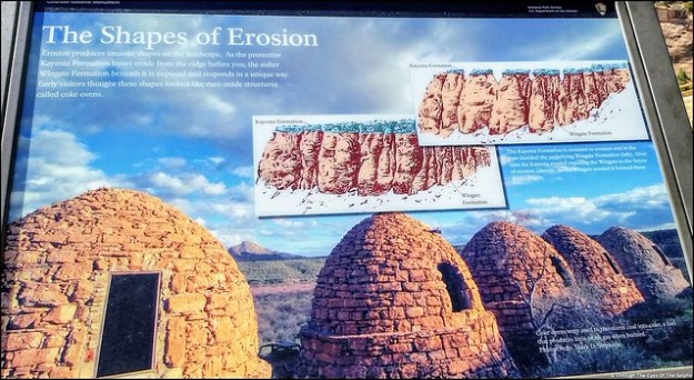
These interesting formations, shaped by erosion, are called Coke Ovens. 20190809_10433520190809_10294520190809_102929IMG_5070_stitch

Also we liked the mummy in the side of the cliff. Do you see it? IMG_5074IMG_5078IMG_5079IMG_5082IMG_508620190809_10432520190809_11260120190809_11273420190809_11280720190809_114338IMG_20190809_114733IMG_20190809_114813

On Saturday Bill attended the Grand Junction Amateur Radio Hamfest. It was a very small Hamfest but Bill always enjoys meeting and talking with other amateur radio enthusiasts. IMG_20190810_093249IMG_20190810_090230

Next stop: Dillon, CO and cooler weather!

Black Canyon of the Gunnison NP, CO AUG 2, 2019

Our time at Ridgway State Park came to an end after six days but we really could have used another two or three days to see everything. Every afternoon we had a rainstorm which hampered our hiking and exploring. There were trails in Ridgway State Park we never got to experience. But our reservation came to an end and we had another reservation waiting at our next destination. 

Next up was Black Canyon of the Gunnison National Park in southwestern Colorado. Formerly designated a National Monument in 1933, it became a National Park in 1999.  IMG_20190802_152647IMG_20190802_154930The Black Canyon is 48 miles long with astonishingly steep walls that rise more than 2,700 vertical feet from the Gunnison River at the base of the canyon. A combination of hard rocks, uplifting, ancient volcanoes and erosion have all played a part in shaping the canyon. It took about two million years to shape the canyon as it is seen today. Fourteen miles of the deepest part of the Canyon are located in the National Park. The narrowest part of the Canyon is 1,100 feet across the top and only forty feet across at the riverbed bottom. IMG_4865IMG_4870IMG_4879IMG_488020190803_135602

The Gunnison River drops over 2,000 feet through the 53 mile canyon. During spring runoff the water can fluctuate from 3,000 to 12,000 cubic feet per second. Water at just 5,000 cubic feet per second can carry rocks up to two feet across and weighing almost 700 pounds. This erosive energy from the river carves the canyon walls deeper faster than it erodes the sides wider. This is what causes the Black Canyon to be much deeper than it is wide. But even at that level of power the canyon only changes about a hair’s width each year. The erosion has been slowed somewhat by construction of dams upstream. IMG_4944IMG_4950IMG_4959

We went to the Chasm View overlook which has the greatest descent of the Gunnison River in the canyon where it drops 240 feet per mile. IMG_4947IMG_4960

The cliff rock is composed of two billion year old metamorphic rock, some of the oldest rock on Earth. It is so steep some parts of the canyon only receive 33 minutes of sunlight a day and the walls are often in shadow making them appear black, hence the name Black Rock Canyon. Gunnison comes from Captain John Gunnison who came to the area in 1853 leading an expedition in search of a route across the Continental Divide for a railroad from St Louis to San Francisco. He was killed by Ute Indians and the river was named in his honor. 

The Ute Indians were the first to live in the canyon long before the first Europeans. They referred to the river as “much rocks, big water” and avoided the canyon due to superstition. 

We camped on the South Rim where there is a Visitors Center and a seven mile paved road with twelve overlooks of the canyon. Most overlooks had a hike to each viewpoint, some short and some longer. Since we were staying six nights in the Park, we were able to take our time. While not terribly hot, at 8,320 feet the sun was very intense. 

We stopped by the Visitors Center with amazing views of the canyon and watched a short movie. IMG_4963

Over the next several days we worked our way along the overlooks. All of the overlooks had dramatic views. From high above we could hear the Gunnison River below, often with whitewater. Definitely not a river you could safely raft in the park. 

One overlook was the Painted Wall, which at 2,300 feet is the highest cliff in Colorado. If the Empire State Building stood on the canyon floor, it would reach only slightly halfway to the top of the cliff. The patterns in the wall were created more than a billion years ago when molten rock was squeezed into fractures and joints of the existing rock, then cooled and hardened. IMG_4979

Another day we took a different drive in the park, the East Portal Road, with a 16% grade and hairpin curves. The road took us down over 2,000 feet to the Gunnison River and two dams. This section of the river was much tamer and could be easily navigated by boat. IMG_4932IMG_4898

Our main reason for driving this road was to see the beginning of the Gunnison Tunnel, built from 1905 to 1909 to carry water to the town of Montrose and the Uncompahgre Valley. Back then the area was suffering from a water shortage due to the influx of settlers. Working underground using only candlelight and manual labor, it took the tunneling crew almost a year to bore through 2,000 feet of water filled rock. IMG_4900IMG_4904The work was so physically demanding and dangerous, even though the pay and benefits were good, men only stayed an average of two weeks before quitting. Twenty six men were killed during the four years of construction. The tunnel was completed in 1909, stretched 5.8 miles and cost three million dollars. The dam is used to fill the tunnel when water is low in the river. The tunnel can carry 495,000 gallons every minute. The Gunnison Tunnel was honored as a Civil Engineering Landmark joining others such as the Statue of Liberty and the Golden Gate Bridge. IMG_4905IMG_4930

Further down East Portal Road is the Crystal Dam built in 1978.  It is a unique structure because it curves from side to side and from top to bottom which gives it exceptional strength. Unfortunately the road to the Crystal Dam was closed and we couldn’t see it close up. IMG_4910IMG_4912IMG_4916IMG_4927

We often saw deer in the park and campground. Because deer often give birth in the campground and are fiercely protective of their fawn, dogs and other pets are not allowed outside each campsite from June 1 to Aug 10th. This year the pet ban was extended to Aug 26th due to late fawning. You are not allowed to carry your dogs in your arms or walk them in the campground outside of your designated campsite. IMG_20190802_160718IMG_20190804_192002IMG_20190807_112233

On our last day in the park we drove to nearby Cimarron to see a restored train that was part of the railroad built in 1882 to pull trains through western Colorado. Here we saw Locomotive #278, its coal tender, a boxcar, and caboose standing atop the last remaining railroad trestle along the Black Canyon of the Gunnison route.  The trestle was constructed in 1895. In 1881 a railroad line was built through the Black Canyon. It took Irish and Italian laborers a year to carve through the tough terrain. It cost $165,000 per mile. In 1882 the first passenger train passed through the canyon. It was said that there were probably not more than a quarter mile of straight track through the canyon. Due to the difficulty in operating and maintaining the track, it was abandoned in the early 1950s.  IMG_5005IMG_5021IMG_5019

Not far from the train display was another dam, the Morrow Point Dam, a 468 foot tall concrete double arch dam. It is the first dam of its type built by the U.S. Bureau of Reclamation and was constructed from 1963-1968. IMG_5016IMG_20190802_204551

Next up:  more time in beautiful Colorado