Category Archives: Museum

Oahu Hawaii FEB 8 2024

After another rough night sailing from the Big Island to the island of Oahu, we arrived at the port in Honolulu in the early morning. We were welcomed with a beautiful rainbow.

Our goal today was to take the city bus from the port to Waikiki Beach to get Bill a shirt at Hard Rock Cafe. We then wandered around the area looking for a food truck on the beach that had garlic shrimp. When we were on Oahu in 2014 we found a roadside stand on the North Shore of the island that had the best garlic shrimp that Bill had ever tasted.  Unfortunately this time around, we didn’t find any garlic shrimp on Waikiki. To show you how wonderful the crew of Holland America are, that evening on the ship one of the chefs stopped by our table. He asked how our day in Honolulu had gone. Bill casually mentioned that he was disappointed he never found any garlic shrimp. The chef immediately pulled out his notebook and made a note to have garlic shrimp especially made for Bill the next night. He said just tell the waiter. Sure enough, the next evening Bill told our waiter, and sure enough the garlic shrimp was prepared for him. How nice is that!

We had a great view of Diamond Head from Waikiki Beach and even from the ship.

In 2014 we rented a car and spent a week on the island of Oahu. The following pictures are from that visit.

Houses are built everywhere

Houses are built everywhere

Diamond Head is the most recognized landmark in Oahu.  The actual name of the volcano is Le’ahi.  It is believed to have been formed about 300,000 years ago during a single brief eruption.  The broad crater covers 350 acres with its width being greater than its height.  The southwestern rim is highest because winds were blowing ash in this direction during the eruption.  Since the eruption the slopes of the crater have been eroded and weathered by wind, rain, and the pounding sea.

Diamond Head got its nickname because in the late 1700’s, Western explorers and traders visited Le’ahi and mistook the calcite crystals in the rocks on the slope of the crater for diamonds.  Imagine their disappointment when they discovered it was not diamonds!  Because of its panoramic view, Diamond Head has been used over the years as a site for coastal defense. Most pictures of Waikiki will have Diamond Head in the background.IMG_3223


Kalaniana'Ole Highway

Kalaniana’Ole Highway

Halona Blowhole

Halona Blowhole

Eastern shore

Eastern shore

IMG_3202

Puu Ualakaa State Wayside Park is on a cinder cone with a breathtaking sweeping view of downtown Honolulu and Diamond Head.  IMG_3228

Overlook of Diamond Head Crater and Waikiki Beach hotels

Overlook of Diamond Head Crater and Waikiki Beach hotels

The National Memorial Cemetery of the Pacific is otherwise known as the Punchbowl.  The cemetery is located in the Punchbowl Crater, an extinct volcanic tuff cone that was formed 75,000 to 100,000 years ago.  The Hawaiian name is Puowaina which means “Hill of Sacrifice” because the area was first used as an altar where Hawaiians offered human sacrifices to pagan gods.  In 1948 Congress approved funding to make it a national cemetery as a permanent burial site for the remains of thousands of World War II servicemen.

National Memorial Cemetery of the Pacific

National Memorial Cemetery of the Pacific

It is a very lovely, peaceful setting with beautiful views of Honolulu and Diamond Head.

How does one even begin to write about Pearl Harbor, such a hallowed place? The USS Arizona Memorial is built over the sunken hull and honors the 1,177 crewmen who died.  The memorial was dedicated in 1962 and the hull is a tomb for over 900 sailors who died inside. IMG_3242

Display of what the USS Arizona looks like underwater

Display of what the USS Arizona looks like underwater

The names of all those who died are on a wall inside the memorial

The names of all those who died are on a wall inside the memorial

Some survivors later chose to be buried inside the memorial

Some survivors later chose to be buried inside the memorial

Also nearby is the USS Oklahoma honoring 429 sailors who died when the ship capsized, as well as the visible hull of the USS Utah Memorial commemorating its 58 dead.

The ships in red were sank during the attack

The ships in red were sank during the attack

Bill took a tour of the Battleship Missouri Memorial which was docked nearby.  The USS Missouri was launched on January 29, 1944, and is the last U.S. battleship ever built.  She is three football fields long and towers over twenty stories tall.  Most importantly, after joining the battle of Okinawa, she became the site of the Japanese surrender on September 2, 1945.IMG_3244 IMG_3253 IMG_3254 IMG_3255 IMG_3258 IMG_3259 IMG_3262IMG_3260

The attack on Pearl Harbor killed 2,400 people and sank or damaged 21 vessels and 323 military planes.

The North Shore area of Oahu is made up of beautiful beaches with dramatic mountains  towering above the shore.  This area is famous for its “pipeline” waves, the massive waves you see at the beginning of the tv show “Hawaii 5-0”.  It is a surfers paradise.  We saw larger waves than we had seen on other parts of the island, but the massive pipeline waves usually occur during the winter months.IMG_3396 IMG_3402

Turtle Beach with no turtles

Turtle Beach with no turtles

Watching the world go by

Watching the world go by

Nuuanu Pali State Wayside Overlook which at an elevation of 1,200 feet had amazing views of Oahu from a stone terrace on the edge of cliffs.  The Hawaiian word “pali” means cliff.  This area is of historical importance to the Hawaiian people because on these cliffs in 1795 is where King Kamehameha won a battle that united Oahu under his rule.  The battle was fierce and during the battle hundreds of soldiers lost their lives, including some who were forced off the edge of the sheer cliffs.

Impressive view of windward O'ahu from Nu'uanu Pali State Wayside (cliffs) at 1200 feet elevation

Impressive view of windward O’ahu from Nu’uanu Pali State Wayside (cliffs) at 1200 feet elevation

A view of Waimea Valley and the northern shoreline from the Puu O Mahuka Heiau on O’ahu

King Kamehameha the first

King Kamehameha the first

The statue is of King Kamehameha the Great (1756-1819), perhaps Hawaii’s greatest historical figure.  There are four statues of the King; this one in downtown Honolulu, on the Big Island at his birthplace, another in Hilo, and in Washington, DC.

We sailed out of Honolulu at 11:00 PM, so no whale watching on our last sail away in Hawaii.

Next up: eight days at sea as we sail towards Guam, including crossing the International Date Line. What day is it????


Flam, Norway JUN 14, 2023

Before we get to today’s port we would like to start with some pictures taken last night as we sailed away from Maloy, Norway.

Never Enough Glaciers

Wind Turbines and Lighthouse We Went To

Today we entered Flam, our last port of this cruise and our last port in Norway. Flam is a tiny village, pop. 350, located at the end of the Aurlandsfjord, one of the world’s longest and deepest fjords. The fjord is surrounded by high mountains with heights over 4,500 feet.

A Tall Waterfall as Seen from the Ship

One of the popular things to do in this area is ride the Flam railway constructed in 1923.  We looked at the excursion before leaving home and even viewed a YouTube video of the trip. We decided to pass considering all the train trips we made in Austria, Slovenia and Italy.

We wanted to explore Flam on our own which meant we could sleep late and let the crowds eat breakfast and get off the ship ahead of us. 

We were delighted and surprised to find the temperature in the low 70’s  Perfect! First we found two geocaches in the area.

We then took a walk to see a large waterfall near town.

We looked through the Flam Railway Museum and went by the Visitors Center. We finished the day with a little shopping. No Hard Rock Cafe here but Bill found a nice Norway tee shirt. I am not a fan of souvenir tee shirts. I was very happy with a refrigerator magnet. 

We noticed yesterday and today how the front of a boat was used as decoration by hanging on the wall. Here a old locomotive front is attached to this wall to appear as it is coming out.

Norway makes it very easy to get the tax back that nonresidents spend. There is even an office located right next to the ship. If you spend at least $30, they refund the tax (25%) back on your credit card. You just have to have a receipt from the vendor, fill out a form and have your passport number. There was quite a line of cruise passengers in the harbor office waiting to get some tax money back. It could add up to quite a bit if you bought lots of souvenirs and gifts.

Trolls Are Famous in Norway

We were back on the ship in time for a very late lunch. A nice day in beautiful, tiny Flam, Norway. 

Next up: Two days at sea before disembarkation back in Southampton, England

Philadelphia, PA NOV 12, 2022

The reason for our November road trip was to attend the wedding of our friends’ son in Bethlehem, Pennsylvania.  We left DC and headed for Bethlehem. Unfortunately the November hurricane was moving up the East Coast so we had heavy rain and fog on our drive to Pennsylvania. It was a beautiful wedding and we had a great time. 

The next day we headed to Philadelphia for a day of sightseeing. First stop was Independence Visitor Center where we saw a film and looked at the exhibits. We had booked a tour of Independence Hall online which was a good thing because it was pretty crowded. Much more so than in DC. I overheard a park ranger tell someone that all tickets had been given out for the day.

We had an excellent tour guide who obviously loves his job. Independence Hall, the birthplace of our nation, is where both the Declaration of Independence and the Constitution of the United States were debated and adopted by the Founding Fathers. The Assembly Room is where they met.

This is the desk and chair where George Washington sat.

Top Section of the Rising Sun Chair

The building was completed in 1753 and was the principal meeting place of the Second Continental Congress from 1775 to 1781 and the Continental Convention in 1787.

Realistic Painting “Congress Voting Independence

Jefferson is the tall man standing holding the Declaration of Independence with Franklin seated in front to Jefferson’s right.

Supreme Court Room

The most recognizable part of Independence Hall is the 168 foot tall bell tower and steeple.

The Centennial Bell rings every hour. When Lincoln’s body was being taken back for burial in Illinois, the train stopped here and Lincoln’s body was placed in the east wing of Independence Hall overnight. Over 300,000 mourners passed through to pay their respects, some waiting five hours. Our tour guide was so entertaining we could easily imagine our Founding Fathers debating in that historic building. 

Next we visited the West Wing to see the Great Essentials Exhibit which included original printed copies of the Declaration of Independence, the Articles of Confederation and the Constitution of the United States. A special exhibit on view was the Declaration of Common Aims, signed in Independence Hall and modeled on the U.S. Declaration of Independence. This document proclaimed independence for the nations of Czechoslovakia, Poland, Yugoslavia, Greece, Romania, Albania, Armenia and Ukraine and autonomy for all the peoples of Europe. One of the guides mentioned this is not a document Russia would want to see.

George Washington

We waited in line for about 30 minutes to get into the Liberty Bell Center. There was no timed entry here and this was the longest line of the day. The Bell summoned members to colonial meetings and rang during important events like the coronation of George III. As discontent increased before the American Revolution, it rang to call citizens to protest Parliamentary oppression. Contrary to popular belief, there is no evidence that it rang on July 4, 1776 to proclaim independence, probably because by this point the steeple was rotted and the swinging and vibrating of the Bell was feared would topple the steeple. The Bell weighed 2,080 pounds. In 1777, the Bell and other valuables were taken to safety just before the British captured Philadelphia.

As a side note, the patriots also took anything that could have been of use to the British army, including blankets, carpets, clothing, anything made of lead including pipes, 4,000 head of cattle and most of the horses they could get. This left the city and remaining inhabitants destitute and in poor shape. Basically they did everything but burn the city. 

The Bell, made in London, England in 1751, was composed of a mix of metals that made it brittle.  The inscription on the Bell, “Proclaim Liberty throughout the land unto all its inhabitants thereof” came from the Bible (Leviticus 25:10).

It first cracked soon after arriving in Philadelphia in 1752. Twice local craftsmen were hired to recast it. The crack in the Liberty Bell we see today was the result of an attempt to fix a thin crack that destroyed the Bell’s tone at some point after the Revolution. There is no record of when the crack developed. It was repaired some time before 1846. The Bell was so popular that metal filings produced during the repair were made into souvenirs and given to public officials and sold to the public. When the Bell rang for George Washington’s birthday anniversary, the original crack reappeared and lengthened, silencing the Bell forever.

Inside View of Crack

Today the Bell is well protected, they even monitor the temperature and  humidity at the Bell. This area was the most crowded and there was a really obnoxious park ranger constantly barking at people to “take your pictures and move on”. I can understand there is a line of people waiting outside, but after waiting 30 minutes plus to get in, I didn’t appreciate being told to move on in a loud, obnoxious voice. 

After a lunch of snacks in the car (thank you Aunt Barbara) we walked down to the Benjamin Franklin Museum. We had originally planned on visiting the Betsy Ross House until I was told that Betsy Ross did not make the first flag. That was just a story made up by her grandson and passed down in the history books. Contrary to what we were taught in school, there is no evidence that Ross made the first flag. It is now considered a myth. And, there is no evidence that Washington cut down his father’s cherry tree and said “Father, I cannot tell a lie”. One of my favorite stories from history.

So we skipped Betsy Ross and went to see Benjamin Franklin. We stopped by his burial site at Chris Church Burial Ground.  Buried next to him is his wife Deborah. There are tens of thousands of coins thrown on Franklin’s marker every year because of his famous adage, “a penny saved, is a penny earned”. In fact the marble marker developed a crack because of the weight of all the coins and a fundraising campaign was started in 2016 to repair the damaged gravestone. Do you see the crack?

From there it was a brief walk to the Benjamin Franklin Museum. This museum had many artifacts and interactive displays on Franklin’s life. Franklin was one of 17 children in a family of Boston tradesmen. His father was a chandler: a candle and soap maker. Franklin wanted to go to sea and threatened to run away. Because of his love of reading, at the age of twelve  his father apprenticed him to his older brother James in a print shop. He was a quick study and learned all aspects of the trade, but because of his brother’s harsh treatment, he ran away from home but kept in touch with his family, frequently writing to them with news of his life.

In His Youth He Created Swimming Fins

Arriving almost penniless in Philadelphia in 1723, Benjamin worked in a print shop and eventually opened his own printing shop in Philadelphia, printing all kinds of things including currency, his own newspaper and Poor Richard’s Almanac. He communicated his ideas and expanded his network of friends and political connections both in the colonies and England. He was rewarded with government printing contracts and the position of deputy postmaster for the Colonies in 1753. Sedan chairs were used by Franklin the oldest member of the Constitution Convention, who was ill and in pain.

Sedan Chair

He improved the postal system by introducing home delivery, printed forms and customer credit. For the first time the Colonial Postal Service turned a profit. He saved enough money to retire from printing at the age of 42.

1760 Painting of Franklin, Stolen During Revolutionary War

This Odometer From Franklin Shows 1,600 Miles

I will say that Bill was more interested in visiting this museum than I was, but I certainly left with a greater understanding and appreciation for this brilliant man.

1847 Franklin Urging the Claims of the American Colonies Before louis XVI

Many Electrical Words He Introduced

Depicts the 1752 Kite Experiment

Some thoughts on Philadelphia. We were apprehensive about visiting Philadelphia. We had heard from several people, including former residents, as well as what we had seen on TV, that Philadelphia was not a safe city to visit. Research before we left home showed that there was a secure, underground parking garage right under the Independence Hall Visitors Center. It wasn’t cheap to park there, but no parking in a large city is cheap or reasonable. But it provided safe parking and was just an elevator ride up to the Visitors Center. We did stay in the safe cocoon of the tourist area, but we did have to walk several blocks to the Benjamin Franklin Museum. We felt safe and didn’t wander further mainly because we ran out of time and we were tired. We did see some homeless, but not many and no panhandling. Granted we were not in the downtown area or neighborhoods, but we were pleased with our experience there.

Franklin Designed the Fugio Cent Coin 1787 with Chain of 13 Circles

1789, Last Portrait of Franklin

We drove by the Philadelphia Eagles stadium on the way to our hotel on the outskirts of the city. Another great day with lots of walking.

Next up: Valley Forge

Touring D.C. Day 3 NOV 10, 2022

Our last day in D.C. we again set out early on a chilly morning. We took the metro and got off at the stop closest to our first planned visit, Ford’s Theater. We had booked a tour of the theater ($5 each) and arrived about 45 minutes early. We asked one of the guides if we could take an earlier tour and he agreed.

Other than reading, one of Lincoln’s favorite forms of recreation was going to the theater. On the evening of April 14, 1865, President and Mrs. Lincoln, sitting in the Presidential Box, attended a performance of the play “Our American Cousin”. At intermission the President’s bodyguard left and went to Star Saloon for a drink and did not return for the beginning of the next act. A stagehand let Booth in through a back door. Booth wedged the door of the Presidential Box open with the leg of a wooden music stand he left there earlier in the day. John Wilkes Booth shot the president in the head. Booth jumped from the stage, got entangled in the balcony decorations, and landed off balance, breaking a bone in his leg. He ran out the back door of the theater, mounted his horse and escaped from the city.

John Wilkes Booth, an actor and native of Maryland, was very familiar to Washington audiences, having performed in area plays. In fact, in November, 1863, President and Mrs. Lincoln went to Ford’s Theater to see the play, “The Marble Heart”, starring John Wilkes Booth. During the play, Booth looked up at the Presidential Box when delivering his most threatening lines. One of the people watching with Lincoln in the presidential box commented that Booth seemed to be saying those lines to the President and Lincoln agreed.

In July, 1864, Booth met with some Confederate agents in Boston and hatched a plan to kidnap Lincoln and hold him hostage in exchange for the release of southern prisoners. On Inauguration Day, 1865, Booth and five of his co-conspirators stood a few feet from Lincoln as he talked about healing the nation. After Lee’s surrender, Booth had to quickly change his plans and he and his conspirators made plans to assassinate Lincoln, Vice President Andrew Johnson and Secretary of State William Seward.

After breaking his leg from his leap from the balcony, he rode to the house of a doctor who set his leg. Booth had planned on escaping through the Maryland countryside to Virginia and then south where he thought he would be a hero. Along with a co-conspirator, and slowed by his broken leg, they were given food and shelter by Southern sympathizers, though many refused to help. On April 26th while hiding in a barn near Port Royal, VA, Union soldiers surrounded them. His co-conspirator surrendered immediately while Booth was shot and died three hours later. He asked the soldiers to “tell my mother I died for my country”. The other co-conspirators were soon arrested, received the death sentence and were hung. Among them was the first woman executed by the federal government. The stagehand who let Booth in the back door received six years of hard labor. The doctor who set his leg was given a life sentence. Initially the doctor said he had not recognized the injured Booth that night. However it was discovered that the doctor had met Booth on three occasions, twice at his farm and once in D.C. He worked on the Confederate underground, failed to notify authorities that Booth had been at his farm, and lied about the direction Booth traveled when he left the farmhouse. President Andrew Johnson pardoned and released the doctor and stagehand in 1869.  They had been sent to Fort Jefferson in Florida. While they were there, the doctor helped many prisoners stricken with yellow fever. He was pardoned for his work at the prison.

President Lincoln, unconscious, was carried to the Peterson house across the street and placed in a back bedroom. The rooms in the Peterson house are 1865 period pieces but none are original to the house. The bed on which Lincoln died is in the Chicago History Museum. The bed was short for the tall president so he was placed diagonally on the bed.

Mrs. Lincoln and their oldest son Robert were with him. Over 90 people would pass through the house to pay their last respects to the dying president. The doctors knew the wound was fatal and Lincoln never gained consciousness. He died the next day, April 15, 1865. Days earlier, General Robert E Lee had surrendered at Appomattox to General Grant. After four + years of struggling to preserve the Union, President Lincoln did not live to see the beginning of the healing process.

Our self guided tour included Ford’s Theater as well as the Petersen House, the house where Lincoln died. Along with us on our assigned tour was a group of high school students. These two historic places really had some interesting displays and facts about the Lincoln assassination. Unfortunately the students were more interested in running around and horseplay. Typical high schoolers. I wish they had taken the chance to learn about this history more seriously.

Last Formal Photo taken February 5, 1865

The museum had Booth’s gun on display. After Lincoln’s death the War Department kept it. In 1931 they received a request to display it at the Ford’s Theater museum. The War Department denied the request saying displaying the gun would “create interest in the criminal aspect of the great tragedy, rather than in the historical features thereof, and would have more of an appeal for the morbid or weak-minded than for the students of history”. The War Department transferred the gun to the National Park Service in 1940 where it has been displayed ever since.

The museum had a replica of the funeral train which took Lincoln’s body on a 14 day, 1,700 mile journey where over seven million Americans viewed the casket as it made its way to Springfield, Illinois for burial. Bill and I visited his tomb in Springfield in September, 2013.

Today Ford’s Theater is a national historical site but also an active theater. In 1866 the federal government bought the theater and in 1932 opened the Lincoln Museum.  It was entrusted to the National Park Service in 1933.

It underwent extensive restoration in 1964. While we were there workers were busy preparing for the next performance.

A portrait of the Lincoln family was painted by Samuel B. Waugh. The print showing Abraham Lincoln, sitting in chair at the left end of a table with Thomas sitting next to him, Mary Todd is sitting on the right, and Robert Todd is standing behind the table.

Painted one Year After Lincoln’s Death

After leaving Ford’s Theater we decided to grab a geocache before our next stop. We found one at the US Navy Memorial Plaza. There have been many times where finding a geocache has taken us places we would not have ordinarily found. This is one of those times, made even more special by the group of Navy veterans visiting that day.

Next up was the National Archives Museum. We did not need a timed pass for this museum.

We came here to see the original documents of the Declaration of Independence, Constitution of the United States and the Bill of Rights. They are located in an area called the Rotunda for the Charters of Freedom. The three documents are known as the Charters of Freedom. They are located in a cool room with dim light to prolong the life of the documents. No photography is allowed for the same reason. The writing on the Declaration of Independence is very faded and hard to read. The parchment document had once been proudly displayed for 35 years in a window of the Patent Office Building where it had been exposed to sunlight. We waited in a short line to get in since they only allow a limited number of people in the Rotunda at a time.

Picture from Condé Nast Traveler

Today, the documents are sealed in glass “in the most scientifically advanced housing that preservation technology can provide”. There is a guard standing by the four-pages of the Constitution of the United States and he will scold you if you lean on the glass for a closer look. (I know from personal experience.) When Bill visited here many years ago he was told that at night they lower the documents into underground vaults for safekeeping. When Bill mentioned that to one of the guards, she said she could not confirm or deny that. Times have changed! 

Picture from Condé Nast Traveler

After a quick lunch at the food court in the Ronald Reagan Building and International Trade Center, we headed to our last stop of the day, the National Museum of American History, part of the Smithsonian. We also did not need an entry pass for this building. We had really looked forward to visiting this museum but it was later in the day and I think at this point we were really tired after three days of sightseeing. We didn’t spend as much time as originally planned and toured the three floors of exhibits/artifacts rather quickly. The first floor had Inventions, American Enterprise and the Value of Money.

Adding Machine from 1927

An Early Portable Computer by IBM, “SCAMP” 1973

The second floor had American Democracy, Many Voices, One Nation and a very interesting Star-Spangled Banner exhibit.

George Washington’s Surveyor Compass

George Washington at Princeton

The third floor had The Price of Freedom, (Bill’s favorite) and the American Presidency and First Ladies exhibits. This was my favorite. Unfortunately all my pictures from the museum are gone from my phone as well as some of Bill’s. We can’t figure out how that happened. 

From the Revolution War Exhibit:

General Charles Cornwallis; letter of surrender and sword.

General Charles Cornwallis was so Mortified by Defeat sent his Second in Command to Surrender and Offer the General’s Sword to Washington.

From the Civil War Exhibit:
From the World War II Exhibit:

We were glad to sit down on the metro and get back to the hotel. Another day of walking 5+ miles had caught up with us. 

Some closing thoughts on D.C. We were really pleased with our D.C. experience. Everyone was very friendly and helpful, from the workers in the metro to the U.S. park rangers and guides in the museums. Everyone seemed really glad we were there and wanted us to have a great experience. The city itself was clean and felt safe. Even the traffic was tolerable. Unlike other U.S. cities in our recent travels, we did not see homeless encampments, people sleeping on the street or panhandlers. 

Next up: a day in Philadelphia

Great Falls, Montana July 21, 2020

We arrived in Great Falls, Montana, (pop 59,000) for a two week stay. Great Falls is the third largest city in Montana. IMG_20200803_131659

It is located along the upper Missouri River where the Lewis and Clark Expedition had to portage around five waterfalls in June 1805 and then again during their return trip in 1806. IMG_20200802_133342L&C Portage Route MTIMG_20200803_131817Within a 15 mile stretch of the Missouri River there is an elevation change of 500 feet. This very difficult 18 mile portage around the falls took over 31 days. This portage was one of the most difficult of their journey. Great Falls gets its name from these five waterfalls. Today the city is called “The Electric City” because each of the falls has a hydroelectric dam. 

We spent time exploring the different falls and dams that make up Great Falls. The falls look much different today than they did during the time of Lewis and Clark because they were altered by the construction of the dams. The falls which at one time was seen as a great obstacle by Lewis and Clark is now seen as of great benefit to supply energy and power to the city. 

Of the five falls, one is not accessible by car and one is submerged. We were able to visit the other three. IMG_20200725_110316

Great Falls/Ryan Dam was the first we visited. When first seen by Lewis and Clark, a measurement of the height was taken by Clark using a sextant and a rod using geometry. Clark estimated the height to be 97 feet and ¾ inches which is remarkably accurate to the 96 feet shown by recent electronic measurements. Clark was only off by a foot! IMG_20200725_111308rThe Big Falls Missouri River MT 1910

To best view the dam and falls we walked across a suspension bridge across the Missouri River to Ryan Island Park. The upper part of the falls were covered by the 1,336 foot Ryan Dam. At first the dam was called Volta Dam after the Italian Alessandro Volta for whom voltage was named. It was later renamed Ryan Dam. IMG_20200725_105958IMG_20200725_110123PANO_20200725_111525.vr

Next up was Rainbow Falls/Rainbow Dam. Captain Lewis referred to this as “Beautiful Cascade”. The dam was constructed in 1910. IMG_20200726_115412IMG_20200726_105423IMG_20200726_105659MVIMG_20200726_105711

The last falls we visited was Black Eagle Falls/Black Eagle Dam. This falls is 26 feet high and 600 yards wide and was the first to be dammed in 1890.  We viewed the falls and dam from the Black Eagle Memorial Island Park which was accessed across a bridge. IMG_20200725_124239IMG_20200726_122717

On the riverfront trail along the Missouri River was a statue of Lewis, Clark and Sacajawea. IMG_20200726_122751-EFFECTSIMG_20200726_122948IMG_20200726_123109IMG_20200726_110616

We also visited Giant Springs State Park, a beautiful state park. Clark first found this great spring in June, 1805 and called it the largest fountain or spring he ever saw. It is one of the largest freshwater springs in the United States. Over 150 million gallons of water flow from Giant Springs into the Missouri River everyday. MVIMG_20200726_111554IMG_20200726_112343IMG_20200726_112419

The springs are the source of the Roe River, which at one time was recognized by the Guinness Book of World Records as the shortest river in the world. Whether or not that record stands today, at only 201 feet in length it is definitely one of the shortest. The Roe River flows into the Missouri River, the longest river in the United States. IMG_20200726_111547IMG_20200726_111655IMG_20200726_112602

Next up we visited the Lewis and Clark Interpretive Center. It was disappointing that both the theater and entire lower level of the Center were closed due to the pandemic. IMG_20200726_114936IMG_20200726_120309IMG_20200726_120309(1)

There were still interesting exhibits and displays here about the Expedition. Meriwether Lewis wrote that he saw more buffalo in this area than he ever witnessed before. Buffalo was a staple diet for the local Native Americans and became a favorite meal for the members of the Expedition. IMG_20200726_115758IMG_20200726_115853

We stopped by the Great Falls Visitors Center which was closed but we did see a nice statue of Lewis, Clark, Sacajawea, York a slave and Seaman the dog. We also found a geocache there. IMG_20200726_135500

We found a nice police memorial nearby. IMG_20200726_135702

On another very hot day we drove to the Upper Portage Camp Overlook. This area overlooks the site of the 1805 Lewis and Clark Upper Portage Camp on the banks of the Missouri River. Even though the landscape has changed over the centuries, it was still a place where we felt a deep sense of history.

IMG_20200802_133524

A Reenactment Of The Boat; In the Background In the Trees Is the Campsite

While Clark directed the portage around the falls, at this site Lewis supervised the assembly of a boat they had hauled in pieces from Harpers Ferry, Virginia. Considered an experiment, the iron boat frame was designed by Lewis in 1803. The canoe shaped frame was 36 feet long and 4 ½ feet wide with nearly 200 pounds of iron strips connected with screws. It was further strengthened with willow limbs and covered with animal skins. It was designed to carry 8,000 pounds. Lewis’ crew labored for weeks preparing 28 elk and four bison hides. Unfortunately during a trial run the boat at first floated like a cork and then sank. Lewis was devastated by the failure and ordered the boat to be buried here.

They then quickly moved upstream and made two large cottonwood boats as a replacement. The iron boat and failed experiment was never mentioned in their journals. A replica of the boat experiment is located here today. 

Meanwhile at the Lower Portage Camp, Clark and the rest of the Corps of Discovery struggled around the five falls. Four times they loaded baggage into six canoes laid upon carts and then pushed and pulled the heavy loads across 18 miles of rugged terrain. They used sails to help them whenever strong winds allowed and endured brutal hail storms. At one point they documented hail as large as seven inches in diameter that bounced 12 feet and landed 30 feet away. It left them bruised and bloodied. They endured heat, rain, prickly pear cactus, and mosquitoes. Through it all Sacajawea, having recently been deathly ill, carried her four month old baby. 

The Expedition all gathered together at the Upper Portage to rest and plan the rest of their journey before leaving on July 13, 1805. They stockpiled meat, wrote lengthy journal entries, made detailed maps, and dug a cache to store items and equipment they wouldn’t need until their return trip when they camped here again from July 13-26, 1806. It was here they celebrated the nation’s 30th Independence Day on July 4, 1805 with a feast of bacon, beans, dumplings, and bison meat as well as singing and dancing. They wrote they fought off mosquitoes and grizzly bears that harassed them daily. 

We also found a geocache here after a long search in the hot sun. 

We enjoyed our time in this historic city except for the extremely hot temperatures. 

Next up: Lewistown, Montana

New Mexico, Sept 2019

Santa Fe RV Rally

We have had an enjoyable slow paced fall. In early September we attended a Family Motor Coach Association – amateur radio rally in Santa Fe, New Mexico. It was an enjoyable four days with eleven couples, a few we had met before and others for the first time. 20190901_18385320190901_184054

It was fun to see all the RVs with their antennas in the campground. IMG_20190903_103553

Santa Fe is a pretty little capital city. This was our third visit to the area. 

Albuquerque and Hamfest

Next up was a month in Albuquerque. We spent the time getting some medical appointments taken care of and working on travel plans for the rest of 2019 and 2020. IMG_20190918_140903

While we were here the Albuquerque amateur radio group had a three day Hamfest which we attended. I studied hard and was able to pass a test to update my amateur radio license from Technician to General operator class. Bill already has an Extra license, the highest level available. 20190921_155647

Trinity Site

Leaving Albuquerque we traveled south to Socorro, New Mexico for a four night stay. Our main reason for stopping here was to visit the nearby Trinity Site. The site is only open twice a year, the first Saturday in April and October. IMG_5192

We have wanted to visit this historic site for several years and this is the first time we have been in New Mexico at the right time. They only open the site twice a year because the site is located on the United States Army White Sands Missile Range where they often conduct missile tests. White Sands Missile Range is one of the most sophisticated test facilities in the world. IMG_5198

Since the site is only open twice a year, it can attract quite a few visitors. I had read that the site opens at 8:00 A.M. but that cars start lining up to get in as early as 6:30 A.M. Since we had an hour drive we left at 5:45 in darkness and heavy fog. It was so foggy we could hardly see to drive.  But even with the fog we arrived at 7:00 and there were about 25 cars in line in front of us. Instead of 8:00 they didn’t open the gate until 8:30 for reasons unknown. We had to pass through security and show our driver’s licenses and confirm we had no weapons or firearms. IMG_5212

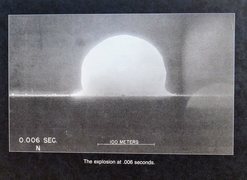
The Trinity Site is where the first atomic bomb was tested early in the morning of July 16, 1945.  The 51,500 acre area where the 19 kiloton explosion occurred was designated a national historic landmark in 1975.  Several potential sites in California, Texas, New Mexico and Colorado were considered but this site was ultimately selected because it was already controlled by the government. It was part of the Alamogordo Bombing and Gunnery Range which had been established in 1942.  The area was secluded which provided secrecy and safety and was also close to Los Alamos where the atomic bomb was designed and built. 

The Trinity Site area where the bomb was placed and exploded is called “Ground Zero”.  It is reached by walking a third of a mile from the parking lot. IMG_5213IMG_5214IMG_5216IMG_5218IMG_5228

An obelisk made of lava stone marks the actual spot. IMG_5226IMG_5229IMG_5233IMG_5225IMG_5222

IMG_5227

This Is What Is Left Of One OF The Tower Legs


They had a replica of Fat Man, the bomb that was dropped on Nagasaki, Japan in 1945. This is the type of bomb tested at the Trinity Site. IMG_5234

We also took a bus from the parking lot to Schmidt/McDonald Ranch House. IMG_5208IMG_5204

This is where the plutonium core to the bomb, about the size of a briefcase, was assembled. IMG_5200

I was interested in the radiation levels at the Trinity Site. They say the radiation levels are very low with the maximum levels about ten times greater than the region’s natural background radiation. Many places on earth are naturally more radioactive than the Trinity Site. A one hour visit to the site will result in a whole body exposure of one half to one millirem. To put this in perspective, Americans receive an average of 620 millirem every year from natural and medical sources. A sequence of pictures taken that day were on display. IMG_5230IMG_5231IMG_5232

As we were leaving the Trinity Site we passed protesters from New Mexico.  They claim families in the area were affected by the testing in 1945 and never received any restitution. We were told the protesters gather every year. 

National Radio Astronomy Observatory – Very Large Array

After stopping home for lunch we decided to make a full day of sightseeing and drove up to see the Very Large Array. IMG_5236IMG_5239

They were having free admission since it was the first Saturday in October. The Very Large Array is one of the world’s premier astronomical radio observatories. It features 27 radio antennas in a Y shaped configuration. Each antenna is 82 feet in diameter and weighs 230 tons. Bill took a 50 minute guided tour of the facility and really enjoyed learning about these radio antennas. IMG_5238IMG_5243IMG_5244IMG_5237

The individual signals are merged to one picture and then colored to add perspective. Here is an example of one picture made from radio wave emissions from outer space. dwarf galaxy UGC5288 gas_large-1006x1024

Here is what radio waves are transmitted when pointed at Saturn. IMG_5240

The Next Generation Very Large Array is underway and will start construction of two hundred plus radio antennas to improve the sensitivity ten times. IMG_5248IMG_5245IMG_5246

We have just a couple more stops in New Mexico. 

Canyons of the Ancients NM, CO July 20, 2019

During our time at McPhee Reservoir Recreation Area, along with visiting Mesa Verde National Park, we also visited other nearby Pueblo dwellings. Down the road from our campground was the Canyons of the Ancients National Monument Visitors Center. We stopped there and watched a movie and picked up a map of Pueblo dwellings within driving distance. IMG_20190716_141257IMG_20190716_14021820190720_122133

The next morning we set out for a day of exploring along part of the 116 mile road named Trail of the Ancients, the only National Scenic Byway in America dedicated solely to archaeology. The first place we visited was Lowry Pueblo, an ancient pueblo site with forty rooms and eight circular kivas. IMG_4540IMG_4541IMG_4551IMG_4555IMG_4557

A roof has been placed over the main dwelling to preserve it. We were able to walk inside for a close up view. IMG_4543IMG_4544IMG_4548IMG_4549

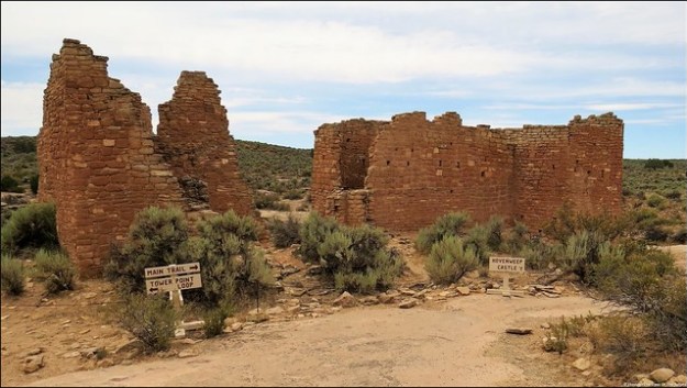
Next we drove to Hovenweep National Monument which lies in both Colorado and Utah.  Hovenweep is a Ute Indian word meaning “deserted valley” which adequately describes the area. There are many multi room dwellings, small cliff dwellings and towers scattered over the canyon slopes. These were constructed by Ancestral Puebloans more than 700 years ago, around the same time as Mesa Verde. Like at Mesa Verde, extended droughts forced the people to abandon the area around 1300 A.D. IMG_455920190720_115011IMG_4562IMG_456020190720_130335

We first stopped at the Visitors Center and watched a movie before taking the Little Ruin Trail to see some of the dwellings and towers. They believe the towers could have been used as storage silos for crops, defensive forts or for ceremonies. IMG_4575IMG_4573IMG_4572IMG_4582IMG_4584IMG_4591IMG_4589IMG_4590IMG_4595IMG_4597IMG_4598

When we returned from our hike we saw a very interesting talk on coyotes by a Ranger. 20190720_122255

We certainly enjoyed our time in southwestern Colorado. IMG_4602IMG_4603IMG_4605IMG_4610

Next up: Rico, CO and cooler temperatures at last

Colorado Tidbits:

  • There are 58 peaks in Colorado 14,000 feet above sea level, more than any other state.
  • Colorado’s nickname is the Centennial State because Colorado was admitted into the union in 1876, the centennial anniversary of the United States.

Mesa Verde NP, CO July 16, 2019

We left Monument Valley and headed to Colorado and hopefully cooler temperatures. It was a beautiful drive with more rock formations and occasional farmland with horses and cattle. We were surprised to see some working oil pumps. 20190714_12572320190714_130203

Our destination was the McPhee Reservoir Recreation Area in the San Juan National Forest for a seven night stay. We had a lovely, private campsite with electric only located at an elevation of 7,200 feet. In the distance we saw snow capped mountains. IMG_20190715_155701

Near our campsite is an overlook of the reservoir.  Where you see water now is where at one time the lumber company town of McPhee stood. In the late 1920’s McPhee was Colorado’s largest lumber mill town with a population of 1,400 and produced over half of the state’s lumber output. In 1948 after a second major fire in a decade destroyed the sawmill, it was not rebuilt. Today the former lumber town is submerged by reservoir waters. 20190719_201653

One day we drove over to Mesa Verde National Park. As we were leaving our campground early in the morning we saw a very large herd of cattle being led down the road to another pasture. It was hard to get a good picture of the large herd because we were facing into the sun. IMG_20190716_070819

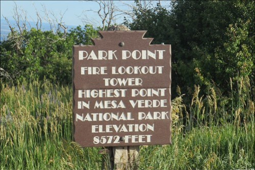
We were last at Mesa Verde National Park in 2015 (see link: Mesa Verde National Park, CO).  The 52,000 acre park is one of the country’s major archeological preserves with almost 5,000 archeological sites including 600 cliff dwellings. Mesa Verde, Spanish for “green table”, was the home of Ancestral Pueblo people for more than 750 years. IMG_20150517_110223 IMG_4506

They lived in the area from around 500 A.D. to 1276 A.D. It was approximately around 1200 when they began to build the cliff dwellings that Mesa Verde is best known for today. When a drought struck that lasted for twenty-four years, it eventually forced the people to leave the area and migrate to New Mexico and Arizona in search of water and better living conditions. IMG_4509

Last time we were here we drove the loop road where some of the larger cliff dwellings are viewed from a distance. In order to see the cliff dwellings up close you have to go on a park ranger led tour for the very reasonable fee of $5.00. IMG_20190716_095017IMG_20190716_095042IMG_20190716_100143IMG_20190716_094632IMG_4516

This time Bill decided he wanted to take the hour long tour of the largest cliff dwelling in the United States, Cliff Palace. He had a reservation for 9:30 A.M. in order to avoid the hottest part of the day. Even though we were now in southwestern Colorado we were still having afternoon temperatures in the upper 80’s. The tour was labeled as strenuous with steep, uneven stone stairs both going and coming and you had to climb four steep ten foot wooden ladders to access the cliff dwelling. I decided not to go and waited in a shady seating area while he was gone. It was the idea of the four steep ten foot wooden ladders that got to me. IMG_20190716_094517IMG_20190716_103253IMG_20190716_103247

Bill had a great time but he did say the walk out was pretty strenuous. He said the ranger did a nice job describing what everyday life was like at the Cliff Palace over 800 years ago. Cliff Palace consisted of about 150 rooms made of sandstone and mortar made of sand, clay and ash. Water had to be hauled in to make the mortar. It is almost inconceivable to imagine how they accomplished this herculean effort in twenty years. In addition to the 150 rooms they had 75 open spaces and 21 kivas, below ground circular rooms used for ceremonies and gatherings. IMG_20190716_101341IMG_20190716_101239

IMG_20190716_101231

Kiva – Round Room Without Roof

IMG_20190716_102739

Picture Taken From Window Of Three Story Tower – Shows Floor Logs


IMG_20190716_102758

After Bill’s tour we stopped at the archeological museum to see a movie about the park and view exhibits and artifacts on the Ancestral Puebloans. IMG_4524
We stopped by the Far View Sites where homes were built on the top of mesas.

IMG_4521

Far View House

IMG_4528

Far View House Walls

IMG_4523

Kiva at Far View House

IMG_4527

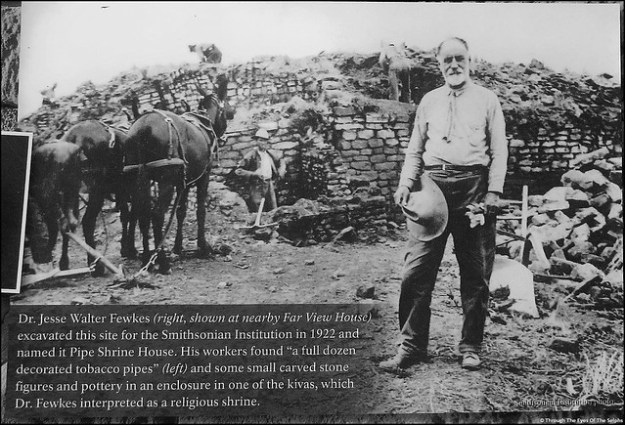
Unique Stone In Outer Wall Of Pipe Shrine House

After a late lunch it was starting to get quite hot and we were very glad we had gotten an early start.

Mesa Verde National Park is an amazing place!

Next up: more exploring in southwestern Colorado

Boulder City, NV APR 12, 2019

Leaving Lake Havasu City we drove to Boulder City, Utah for a six night stay. Boulder City (pop 15,600) is a lovely city which was built in 1931 to house workers contracted to build Hoover Dam, formerly called Boulder Dam. 20190413_150655Previously, men who hoped to work on the Dam were living with their families in tents and shacks on land chosen as the site of the Dam. The town was built by the Bureau of Reclamation as the “Boulder Canyon Project Federal Reservation”.  Federal rangers maintained law and order on the “reservation”. Boulder City is very rare in that it was fully planned under government supervision. The town was designed to house around 5,000 workers and the status of the workers was reflected by the size and location of their house. Commercial development was restricted and severely limited by a stern, iron fisted city manager. There was no provision for schools at first because it was assumed only single men would be working on the Dam. No hospital was built for years with injured workers taken to nearby Las Vegas. When a hospital was eventually built, it was a number of years before females were allowed to be admitted.  Visitors to Boulder City had to go through a gatehouse, and gambling was prohibited. Today, Boulder City is one of only two Nevada cities which prohibit gambling. Alcohol was prohibited until 1969. Las Vegas had campaigned to have the workers housed in Las Vegas but because of its rowdy, risqué reputation, it was passed over in favor of Boulder City. Today Boulder City is very proud of its nickname “Home of Hoover Dam”. The federal government gave up control of Boulder City in 1959 when it was incorporated.

We visited the Boulder City-Hoover Dam Museum located inside the historic Boulder Dam Hotel. The hotel, built in 1933, is on the National Register of Historic Places. 20190413_150536

In the 1930’s and 1940’s the hotel was the accommodation for Shirley Temple, Betts Davis, Howard Hughes, Will Rogers, Boris Karloff and other celebrities who came to see the Dam being built. The museum had an excellent movie and exhibits on life in Boulder City in the 1930’s as well as the construction of the Dam.  Working conditions were hard and treacherous to say the least. Because of a fine of $3,000 for every day the construction ran over deadline, the men were pushed to the limit and often competitions were used to push the men even harder. 20190413_13514720190413_135544Occurring in the days immediately after the Great Depression, men were afraid to complain of unbearable heat and working conditions for fear of being fired. Only American citizens could work on the Dam which essentially meant whites only. In 1932 only a few African Americans were hired but were not allowed to live in Boulder City. This changed after Franklin Roosevelt was elected.20190413_13512820190413_13502320190413_135556IMG_20190413_14030020190413_134902

We enjoyed walking around the town doing some geocaching. Evidence of the town’s history was everywhere. 20190413_150356

IMG_20190413_144457

34 Ton Water Runner Converts Water Power To One Generator

One day we drove to the nearby Lake Mead National Recreation Area. This is the nation’s first national recreation area and the largest reservoir in the country. It was formed by the Hoover Dam in 1935 and provides water to twenty million people and farmland in Arizona, California and Nevada as well as some to Mexico. The Lake has not reached full capacity since 1983 due to water demands and drought. In August, 2017 it was only at 40%.

Our main reason for going there was to hike the Historic Railroad Trail. IMG_20190415_122735This trail is a portion of the former railroad route that carried supplies from Boulder City to Hoover Dam during construction of the Dam. The trail is no longer a railroad but has been replaced with crushed rock. Along the trail are panoramic views of Lake Mead. 20190415_123839Hikers pass through five tunnels approximately 300 feet in length and 25 feet in diameter. The trail can take you all the way to Hoover Dam but on this day we had to stop at tunnel three because the tunnel was closed due to unstable conditions. Since it was a hot sunny day with no shade on the trail, we were okay with turning around at that point. We had walked 10,000 steps by the time we returned to the car. 20190415_12590020190415_123435IMG_20190415_123702

We then drove to Hoover Dam. Back in Jan, 2015 we visited Hoover Dam and took a tour of the facility. This time we wanted to stop at the visitor area at the Mike O’Callaghan-Pat Tillman Memorial Bridge which is the first concrete-steel composite bridge in the United States and the widest concrete arch in the Western Hemisphere. IMG_20190415_141507At 880 feet above the Colorado River it is the second highest bridge in the United States and the world’s highest concrete arch bridge. IMG_20190415_142635IMG_20190415_143317IMG_20190415_143255The bridge connects Arizona and Nevada.  The visitor’s area, in Nevada was super busy with limited parking. I did the musical chairs game with all the other cars trying to find a parking spot. In the meantime Bill walked up the steep trail to the top of the Bridge. It was a very windy day and when he walked out onto the bridge he took his sunglasses off because he was afraid they would blow off his face! IMG_20190415_142510IMG_20190415_142145He took some great shots of Hoover Dam from the top of the bridge. IMG_20190415_142156

We then drove from Nevada over the dam to the Arizona side to have another look at this marvelous structure.

IMG_20190415_145237

Hoover Dam from the Arizona Side With Memorial Bridge in the Distance

Another day we hiked around the Nature Discovery Trail and Rock Garden. We loved the beautiful rocks, desert flora and giant statues of desert animals. Plaques gave interesting facts about the animals and flora. Did you know jackrabbits can run up to forty miles an hour or that the roadrunner can survive its entire life without drinking water but receives moisture from its prey? 20190413_15225920190413_15273720190413_15262620190413_153051

We finished the day by finding a geocache at the Nevada State Railroad Museum. We not only found a geocache but some great old trains too. IMG_20190413_155028

Railway Post Offices (RPO) were used to transport and sort mail using the hanging mail bag system. RPO were started in the 1830’s and ended in 1950’s. IMG_20190413_160306IMG_20190413_160526IMG_20190413_160534

We had a wonderful time in Boulder City.

Here is the link to our previous visit to Hoover Dam where we took the inside tour January 27, 2015 Boulder City, Nevada

Next up : Valley of Fire State Park, Nevada

Los Angeles, CA, Part 1, Nov 5, 2018

We just finished a two week stay at an RV park in Acton, California where the winds and threat of wildfires were a constant worry. Acton is located about forty miles northeast of Los Angeles.  The Santa Ana winds were fierce, blowing dust and dirt which left us with itchy eyes and everything covered in dust. We kept a very close eye on the California wildfires and thankfully we remained safe. We had an emergency plan and stayed ready to leave quickly if we got the word. My dear friend in Paradise lost her home and everything they owned in the fire. Sara and I taught together in Charlottesville many years ago. Bill and I visited Sara and her sweet family in Paradise just seven months ago. Now the entire town is gone and the citizens are trying to pick up the pieces. The fires in Paradise and Malibu made us nervous, watchful and diligent.

In spite of all this we did manage to get into Los Angeles for some fun. One day we drove in to see a taping of the TV show “Last Man Standing” at CBS Studios in Studio City. (Even though it is shown on Fox television, it is filmed at CBS Studios). During the drive we could see smoke from the Malibu fires in the distance. 

20181109_131236

Smoke that is 25 Miles Away

Since the taping wasn’t until 6:00 P.M. we had time to first go by Forest Lawn Cemetery at Hollywood Hills. The cemetery is huge with different sections, including an area with a statue of George Washington and a replica of the Old North Church in Boston. IMG_20181109_142517IMG_20181109_151807

We found the plaque describing the statue particularly interesting. It said, “Washington wears the uniform of the army he had led through six bitter years of war. In the midst of battle his fearless example inspired his men.  When hunger stalked his weary troops he shared their lot. When his own officers betrayed him he fought on so that generals from nations across the sea came one by one to serve him proudly.  And at last God granted his prayers for victory and peace. The seated figures represent the forces that shaped his life: oppression, revolution, victory and the return to peace symbolized by Cincinnatus, the citizen soldier. The portrait busts are those of Washington’s finest generals: The Marquis De Lafayette, Benjamin Lincoln, Nathanael Greene and Henry Knox.”

A large mural of historical events along a back wall said “God Gave Us Liberty. People Who Forsake God Lose Their Liberty”. IMG_20181109_144104a

Many famous people are buried there but we had limited time so we only had time to find a few headstones. Among them was Gene Autry, Bette Davis, Debbie Reynolds and Carrie Fisher who are buried together, Stan Laurel, Liberace, John Ritter and Telly Savalas. If you are interested in what any of these grave markers look like we are posting those pictures at the end of this blog. 

After grabbing a quick early dinner we headed to the studio. Four years ago we went to a taping of “Last Man Standing” and a high school friend of mine was a writer on the show. She was able to get us VIP tickets with great seats, and even though she is no longer a writer on the show, I contacted her and once again she got us VIP tickets. Even though it is only a thirty minute show, the taping took two and a half hours since each scene was shot at least twice. In recognition of the very early dinner we had before the show, halfway through the taping they served everyone in the audience a slice of pizza! Unfortunately they do not allow cell phones or cameras in the studio so we have no pictures to share. It was a fun experience and since it was 9:00 P.M. by the time we got on the road toward home, the worst of the rush hour had passed!

Another day we drove back into Los Angeles and visited the Autry Museum of the American West. IMG_20181113_141141IMG_20181113_141257

The museum explores the history of the American West. It has more than 500,000 pieces of art and artifacts including the Southwest Museum of the American Indian Collection, one of the largest and most significant in the United States. 20181113_151811IMG_20181113_151802

Admission to the museum is free the second Tuesday of each month and we were lucky to visit on that day. Of particular interest to Bill was the extensive gun collection, though not as extensive as the one at the Cody Museum in Cody, Wyoming. IMG_20181113_143957a20181113_14443620181113_144535IMG_20181113_145804IMG_20181113_145959a

IMG_20181113_143107

1837 Colt Pocket Model Single Action Revolver – Featured a hidden trigger that appeared when cocked

IMG_20181113_150936

1873 Colt Single Action Army Revolver

IMG_20181113_145102

Gene Autry Revolver

Many Colt revolvers were especially engraved for presidents. The pistol below was made for President Reagan. 

IMG_20181113_145340IMG_20181113_145307

We really liked a mural called “Spirits of the West” with famous people such as Roy Rogers, the Lone Ranger, Marshall Dillon, Teddy Roosevelt, Gene Autry, Clint Eastwood and John Wayne to name just a few. IMG_20181113_152228IMG_20181113_152256IMG_20181113_152341IMG_20181113_152249

IMG_20181113_152500

John Wayne and Gene Autry

IMG_20181113_152447

Theodore Roosevelt Jr.

We also visited Pierce Brothers Westwood Village Memorial Park, a small cemetery tucked into a corner of a busy urban area. The cemetery is so hidden from view it is hard to find and we actually had to ask a local where the entrance was located. There we found the graves of Marilyn Monroe, Don Knotts, Eddie Albert, Eva Gabor, Dean Martin, Merv Griffin, Jack Lemmon, Natalie Wood, Donna Reed, Carroll O’Connor, Walter Matthau, Burt Lancaster, Bob Crane, Peter Falk, Florence Henderson, Jim Backus and Brian Keith. We were really struck by the simplicity of most of these graves of very famous people. We especially loved Don Knotts headstone! IMG_20181113_122258

Once again the pictures are at the bottom of the blog. IMG_20181101_182408

Next up: more sightseeing fun in the LA area

Forest Lawn Cemetery at Hollywood Hills:

IMG_20181109_134926IMG_20181109_135551IMG_20181109_140710IMG_20181109_14151420181109_142821IMG_20181109_144318IMG_20181109_150924

Pierce Brothers Westwood Village Memorial Park:

IMG_20181113_121252IMG_20181113_121349IMG_20181113_121439IMG_20181113_121433IMG_20181113_12243920181113_122954IMG_20181113_123005IMG_20181113_123457IMG_20181113_124112IMG_20181113_124239IMG_20181113_124401IMG_20181113_124430IMG_20181113_124958IMG_20181113_125030IMG_20181113_125307IMG_20181113_125515IMG_20181113_125523IMG_20181113_125531IMG_20181113_125600