Category Archives: Museum

Day Trip to Santa Barbara, OCT 31, 2018

Continuing our stay at the Ventura County beach park, on Wednesday we drove to Santa Barbara to look around the town. Our first stop was at the Reagan Ranch Center. 20181031_12420820181031_124232

The Center, called the “schoolhouse for Reaganism, is a Young America’s Foundation Center dedicated to Ronald Reagan.  20181031_124814 

There are exhibits about Reagan as well as rooms for lectures, conferences, events related to the conservative movement  and a replica of his library at the ranch. 20181031_13252320181031_132542

The Center is free and we were given a tour by a Center docent. We saw a movie about President Reagan’s presidency, policies and life at his nearby ranch. The Reagan ranch, Rancho del Cielo (Ranch of Heaven) is not open to the public. IMG_20181031_13335820181031_132932

During his presidency the ranch became the Western White House.  He loved spending time there chopping wood, clearing brush, chopping up telephone poles for fences, riding horses and reading in the evenings by the hearth. Reagan loved the ranch, the land and all it represented. IMG_20181031_13190920181031_132805

The Center has a chapel room with President Reagan’s favorite verse printed on the wall. This was was his mother’s favorite verse, the verse he mentioned during his inaugural address in 1981, and the family Bible was open to this verse when he took his oath of office. His mother, Nelle, had written in the Bible beside the verse, ‘A wonderful verse for the healing of a nation”. 20181031_125706

We saw Reagan’s riding boots, a piece of the Berlin Wall, his jeep given by Mrs. Reagan for his birthday in 1983 and one of his saddles.20181031_12483320181031_13283620181031_13234820181031_132357

It was hard to get pictures at the Center because of glare from the museum lights. (An example is the picture of his boots where it looks like the top of one boot is missing due to bad glare). 20181031_12463520181031_13004320181031_12494020181031_125955

Next up was the Moreton Bay Fig tree, the largest fig tree in the United States. A seaman visiting Santa Barbara in 1876 gave an Australian Moreton Bay fig tree seedling to a local girl who planted it. IMG_20181031_134017IMG_20181031_134144

Last we toured the Santa Barbara County Courthouse, without a doubt the most beautiful courthouse we have ever visited. It was completed in 1929 after the first courthouse was destroyed by an earthquake. It is a Spanish Colonial Revival style architecture and the Spanish influence is everywhere. IMG_4460

The courthouse is composed of four buildings with red tile roofs, a four faced clock tower, beautiful arches and a sunken garden. On the grounds are plants and trees from 25 countries. You enter the main building and see wrought iron chandeliers and railings and colorfully tiled floors.  Even the walls around the water fountains are tiled as well as the elevator doors. 20181031_14433120181031_144750

Our favorite room was the mural room with hand-painted murals. IMG_20181031_14551420181031_14550520181031_14545120181031_145439

Bill did a panoramic shot of the room. If you click on the image and then again the arrow and move the picture (up/down/left/right) with your fingers, hopefully you can see around the room.  Click this link to see panorama interactive image

In the clock tower we had gorgeous views of Santa Barbara. At each of the four corners was a display showing us what we were looking at. 20181031_150418IMG_446620181031_15060620181031_150640

On the way back down the stairs we passed the Bisno Schall Clock Gallery where we could see the mechanism of the huge clock installed in 1929 and still keeping time on the four faces outside. IMG_4469

What a great day, and we were pleased that none of the places we visited today charged a fee and Santa Barbara provides plenty of free parking. The only annoying part of the day was the rush hour traffic jam we got in on US 101 on the way home.

We really enjoyed our time on the beach in Ventura watching the surfers, viewing the amazing sunsets and going to sleep each night to the sound of crashing waves.

Next up: lots of fun things in the Los Angeles area

Chimacum, WA July 19, 2018

When we left Birch Bay, which was our northernmost point in Washington this year, we planned to go to a campground near Port Townsend, Washington. We had a decision to make.  We could either drive over four and a half hours down to and around the Seattle /Tacoma area and fight horrendous traffic, or we could drive 90 minutes to Oak Harbor and take a thirty minute ferry over to Port Townsend. Hmmm. Even with the cost of gas, the ferry was the more expensive way to go. So, take the much longer way through terrible traffic and spend less money or shorten the trip by more than half, enjoy a leisurely scenic trip on the ferry but spend more money. What would you do? Yep, we took the ferry! 20180719_114616

From the ferry we had a short ten mile drive to our campground in Chimacum, just outside of Port Townsend, where we had a very nice campsite.

On Sunday we drove down to Bremerton.  On the way we stopped in the charming little town of Poulsbo and on the advice of our friends Peter and Beth we stopped at Sluys Bakery.  We waited in a line stretching out the door and had the best donuts we had ever eaten in this little family owned bakery. The very picturesque town of Poulsbo, overlooking Liberty Bay, has a strong Scandinavian heritage which is evident throughout the town.  In the 1880’s ninety per cent of the town’s population was Norwegian. 20180722_10381420180722_103915IMG_20180722_104808IMG_3205

After finding a couple geocaches we stopped at the nearby U.S. Naval Undersea Museum, an official naval museum which talked about the ocean environment, submarine technology, undersea weapons as well as diving and salvage.  IMG_3206IMG_3209IMG_3210

This is one of ten Navy museums operated by the Naval History & Heritage Command whose purpose is to preserve and collect Naval undersea history and science. Exhibits included U.S. torpedoes including the Howell torpedo IMG_3207IMG_20180722_120201

and a simulated control room from the USS Greenling. IMG_3211

Other exhibits show the NOMOADS underwater suit. IMG_3214IMG_3215

How the US Navy uses marine life to augment searches. IMG_3213

Next we continued on to Bremerton, home of the Naval Base Kitsap-Bremerton and the Puget Sound Naval Shipyard established in 1891, the city’s largest industry.

Bill took a tour of the USS TURNER JOY, a former U.S. Navy destroyer 1959 to 1982. IMG_3216IMG_3217IMG_3218

The vessel was named after Admiral Charles Turner Joy and constructed here a Puget Sound Naval Shipyard.

The USS TURNER JOY has been restored to her Vietnam War configuration and most of the rooms and facilities are open and appear to be operational. 

IMG_3226

Medical Bay

IMG_3227

Engine Room

IMG_3219IMG_3220IMG_3224

Every fifteen years stationary ships must have their keel cleaned. Last year the USS TURNER JOY was moved to a shipyard to have the barnacles removed. IMG_3228IMG_3230IMG_3232

On Tuesday we did some geocaching in Port Townsend, including at Fort Worden State Park where the movie “An Officer and a Gentleman” was filmed.   20180724_145125IMG_3235IMG_3237

On the way home we came across a doe and her two fawns. The fawns were happily prancing along the side of the road. IMG_3242IMG_3243

Next up we continue west to Salt Creek Recreation Area near Port Angeles, WA.                                                                                                                                    

Woodland, WA June 3, 2018

After two wonderful weeks at Seaside, Oregon we headed northeast and crossed over Columbia River into Washington state.  20180603_16050120180603_16053420180603_160621We settled into a private campground in the town of Woodland. We loved our campsite with a front row view of the Columbia River.  During our week-long stay we really enjoyed watching the ships, boats and tugs sailing between Portland and the Pacific Ocean. 

IMG_20180606_162641

This boat is being towed by four togs.

IMG_20180607_110341

This is an auto carrier that was coming from San Francisco to Portland

IMG_20180607_113140

This Navy ship is on the way to Fleet Week at Portland

IMG_20180604_11353120180604_094919IMG_20180605_104844IMG_20180609_114040

Unfortunately the day after our arrival Bill came down with a very bad stomach virus so several days there were spent recovering.

IMG_20180606_111424

Mount Hood in Oregon

Later in the week we took a drive along the Historic Columbia River Highway where we passed back into Oregon and visited two waterfalls.  

First up was the popular Multnomah Falls, which at 620 feet is the tallest waterfall in Oregon. IMG_20180606_114214IMG_20180606_113934IMG_20180606_115255

We last visited here in 2014. We had hoped to hike to the bridge you see in the picture.  We were very disappointed to learn the trail to the bridge has been closed due to severe damage from wildfires last year. The wildfires that did millions of dollars in damage was caused by a child playing with firecrackers.  We asked a couple people when the trail and bridge would be reopened. One person said a couple weeks and another said a few years!

From there we drove to Latourell Falls.  We hiked up a short but very steep trail to a view of this lovely 250 foot waterfall. IMG_20180606_132306IMG_20180606_131340-EFFECTSIMG_20180606_131718

IMG_20180606_142418

Mount Adams in Washington

On the way home we stopped at The Crown Point Vista House with a fabulous view 733 feet above the Columbia River.  The Vista House is a museum of the Columbia River area and a memorial to Oregon pioneers. IMG_20180606_133817IMG_20180606_135744

Next stop:  Chehalis, WA

Lodi & Sacramento, CA APR 12, 2018

Leaving the Hollister area we drove to the town of Lodi for a stay at the Elks Lodge. Lodi is a major wine producing region with more than 80 wineries located in the area. The town has nicknamed itself the “Zinfandel Capital of the World”. We enjoyed doing some geocaching and found the people to be very friendly.

20180415_152145

Beside the road was this exchange library where we found a geocache hide

Next up was the town of Nicolaus about thirty miles from Sacramento, the capital of California. Even though we drove on major highways, the roads were really rough in some places.  California really needs to spend some money repairing their roads!

On Saturday we drove into Sacramento to visit the state capitol building. It is our quest to visit every capitol building in the country. I will start with the bad comments first.  You may have heard on the news that California has an alarming number of homeless people living on the streets. That fact was very evident in Sacramento. I am not usually frightened by this, but in Sacramento wherever we were there seemed to be several people arguing loudly, cursing, and in one instance approached me for money. It is common to see people wandering the streets with suitcases or carts with all their belongings or sleeping along the roads and in parks. In and around the city, bathrooms in restaurants and stores are locked and you must ask to use the facilities. Their situation is very sad, very disturbing and a little frightening.

California has a lovely state capitol building and we took their tour with an exceptional tour guide. IMG_20180421_111813IMG_20180421_111851IMG_20180421_111919IMG_20180421_115036

He clearly loves his job. California became the 31st state in 1850 and construction on the capitol building began in 1860 and concluded in 1874.  Sacramento was chosen as the capital during the gold rush era because it was located near the highly populated gold rush areas. The capitol is modeled after the U. S. capitol building and has a beautiful 120 foot high rotunda. IMG_20180421_124646

IMG_20180421_124936

A page boy, Queen Isabella and Christopher Columbus

We loved the statue of Ronald Reagan and seeing the legislative chambers. 20180421_11403620180421_121909

IMG_20180421_123958

George Washington portrait overlooking the State Senators

We heard an interesting story about the portrait of former governor Arnold Schwarzenegger. He had the portrait commissioned by an artist in Austria, his birth country. The artist chose not to give it an ornate frame or nameplate like the portraits of other past governors and it was hung that way. Not having a nameplate may not be a problem now, but 100 years from now will people recognize the governor without a nameplate? IMG_20180421_121410IMG_20180421_121433

We went into the gift shop and this bumper sticker caught my eye. 20180421_114419

The capitol building is located on a 40 acre park. We always look for the Liberty Bell located at all state capitals. IMG_20180421_130037IMG_20180421_130100

Next we visited nearby Old Sacramento, a four block area that was the city’s commercial district during the gold rush era and pony express.

The area has cobblestone streets and wooden walkways which give it a feeling of yesteryear. It is very much a tourist area today with restaurants, souvenir shops, carriage rides, paddle boat tours and train rides. We visited the Wells Fargo History Museum. IMG_20180421_143245IMG_20180421_143226IMG_20180421_144242IMG_20180421_144304IMG_20180421_145749IMG_20180421_150506

IMG_20180421_150519

The Sacramento River is crossed by this yellow bridge

Watch their train here: 

We finished the day at Sutter Fort State Historic Park, site of the first European outpost in California. IMG_20180421_155124IMG_20180421_162517

It was established by Swiss immigrant John Sutter with a land grant from the Mexican government and was known as New Switzerland. IMG_20180421_161401

After the discovery of gold the land were taken from Sutter by prospectors. We were surprised to find that the original structures were made by men from Hawaii. IMG_20180421_160405IMG_20180421_160411IMG_20180421_160716

On Monday we made the long drive from Nicolaus to visit Donner Memorial State Park. In order to get there we had to drive over Donner Pass using I-80 and the Lincoln Highway, elevation 7,227. IMG_20180423_12121120180423_143220  

The snow was beautiful on this bright sunny day. IMG_20180423_115410IMG_20180423_122257IMG_20180423_122441

The state park had a very nice visitors center with displays and a movie about the Donner party, a group of pioneers who set out from Missouri for California in May 1846 in a wagon train. 20180423_135733IMG_20180423_135926

The trip usually took four to six months, but due to mishaps and bad decisions they found themselves snowbound in the Sierra Nevada Mountains during the winter of 1846-1947, a record breaking snowy winter.

Of the original 87 pioneers, only 48 survived. It is one of the most famous and tragic tales of pioneer journeys, which included cannibalism to survive. 20180423_135816

On the state park grounds is a monument to the Donner party. IMG_20180423_144029

Next stop: Paradise, CA to see a former co-worker from my teaching days

Ridgecrest, Buena Vista REC Area, Hollister, CA MAR 30, 2018

After leaving Death Valley National Park we traveled back to Ridgecrest for three nights. Bill visited the China Lake Museum whose mission is to preserve the history of the Navy’s spectrum of weapons research, development and testing. Formerly located at the China Lake Naval Weapons Center, the museum is being relocated off base to make it more accessible to the public. China Lake was started to develop missiles and also was involved in the Manhattan Project. IMG_20180327_123504IMG_20180327_113458

After three days in Ridgecrest we headed north to Buena Vista Aquatic Recreational Area near the tiny town of Taft, California.  Along the way we passed field after field of solar panels and occasionally wind turbines.20180329_114206

The terrain changed from a dry rocky landscape to the agricultural California Central Valley.  We passed field after field of crops, citrus trees and grapes.20180329_132048

We could see aqueducts helping irrigate the fields as well as political signs from farmers asking for more dams instead of the proposed funding for the high speed rail between San Francisco and Los Angeles.20180401_132331

We had a campsite with a view of the lake and enjoyed a peaceful weekend even though it was Easter weekend and the park was full of families. We enjoyed just relaxing and some walks around the park with beautiful sunsets.IMG_20180330_185258

We left Taft and headed to a campground near Hollister, California for a nine night stay.  Hollister is one of three towns in California claiming to be the “Earthquake Capital of the World” because it was built directly on the very geologically active Calaveras Fault, a strand of the greater San Andreas Fault. One evening we felt the earth gently shake and later learned it was a 3.0 earthquake. No big deal.

IMG_20180403_110958Our main reason for visiting this area was to visit Pinnacles National Park. Formerly a national monument established in 1908, it became a national park in 2013, the 59th national park and our newest national park.

The pinnacles are eroded leftovers of the western half of an extinct volcano that was once part of the San Andreas Fault. The park is divided by the rock formations into an east division and a west division with no road connecting the east and west sections of the park.IMG_20180403_113731IMG_20180403_123837

The park has numerous unusual talus caves that are home to more than thirteen species of bats. Talus caves are not like the typical limestone underground caves.  In fact they are not really caves at all. They are formed when steep, narrow canyons are filled with a jumbled mass of boulders from the cliffs above which happened during the ice age. There is no known evidence of the existence of any Native Americans ever living in the talus caves.IMG_20180403_125057

One day we drove to the eastern section of the park which was more easily accessible from our campground. We stopped by the Visitors Center for trail information.  

We discovered there are not a lot of hiking trails in the park, and the trails they have are either rated moderate or strenuous. After talking with a ranger we chose the Bear Gulch Cave and Moses Spring Trails after her assurance it was not a difficult trail. The hike started with a fairly uphill walk until we reached the cave.IMG_20180403_115953IMG_20180403_115236IMG_20180403_120152IMG_20180403_115516

Upon entering the cave we had to rock hop over a series of rocks to keep our feet from getting really wet. Hmm, don’t remember the ranger mentioning this. As we continued on the cave was so dark we had to use a flashlight and light from our cell phone as we began to climb a series of steep steps cut into the cave walls.IMG_20180403_120957IMG_20180403_121224

Hmm, don’t remember the ranger mentioning this. To our left we could hear, but not see running water. Illuminating the area the best we could with the flashlight, we could see a series of waterfall.IMG_20180403_121123

Our path continued either over rocky terrain or steep steps with occasional very narrow passageways we had to squeeze through. At the end of the cave the exit was so low we had to get down on our knees and crawl out. Hmm, the ranger didn’t mention this!20180403_121606IMG_20180403_121655

Once out of the cave we continued on the trail to the reservoir. Once again we climbed steep rocky stairs and at the top emerged into an oasis of water and a few trees. IMG_20180403_123208IMG_20180403_123417IMG_20180403_123422 

After resting a while and enjoying the view we went back down the steep stairs.IMG_20180403_123929IMG_20180403_124035PANO_20180403_12364820180403_124333

Luckily the trail back to the parking lot didn’t not take us back through the cave, though we noticed some people choosing that option. Once was definitely enough. On the way back we passed along some high rocky walks where Bill heard growling from above.  This made us nervous since the area is known as home to bobcats.20180403_130713

We arrived back at the car hungry for our picnic lunch and a rest.

Another day we visited the west side of the park which required a much longer drive from our campground to access the west entrance.IMG_20180409_11544320180409_12532920180409_13024720180409_130948

This side of the park was much quieter and appeared to be less visited. We enjoyed chatting with the friendly park ranger who suggested a brand new trail. This easy one mile loop gave us great views of the pinnacles.

Next up we head to Yosemite National Park to see the many spring waterfalls.

Death Valley National Park, CA MAR 23, 2018

Death Valley National Park has been on our bucket list for a long time. After three days of wind and rain, we woke up to sunny skies as we left Ridgecrest and traveled to Death Valley.  It was not far, but not an easy drive as we passed over two mountain passes, with the second pass at an elevation of almost 5,000 feet. It was then quite a drop down to sea level, a real workout on the brakes!20180323_11575320180323_11110920180323_110939

Death Valley National Park is made up of 3,336,000 acres, making it the largest national park in the lower 48 states and one of the biggest expanses of protected warm desert in the world. There are four National Parks in Alaska which are larger.IMG_20180324_143846

Death Valley is the lowest point in North America and the hottest, driest weather in the country.  It is officially the hottest place on Earth and holds the world record for the hottest air temperature of 134°F.  The valley’s steep mountain walls trap the rising hot air and recirculates it down to the basin for further heating. It has the lowest average rainfall of any place in the country with less than two inches per year, with some years no rain at all. Once again the mountains are to blame.  The mountains capture moisture from passing storms before it can reach the valley.IMG_20180325_170746

Several people have asked us what the weather was like while we were there. This was a great time of year to visit with daily temperatures in the low 70’s with a nice breeze. At night we slept with the windows open.IMG_20180324_141924

One day we stopped by the Visitors Center and saw a twenty minute movie about the park. We then drove through the south end of the park, stopping at Zabriskie Point with beautiful views.  There are many times in our travels over the past five years where places have surprised us with their beauty and exceeded our expectations. Death Valley was definitely one of those places.20180324_130702IMG_20180324_13095420180324_13115520180324_131240IMG_20180324_131357

We took a drive down the Twenty Mule Team Canyon Road which was named for the twenty mule teams which pulled wagon loads of borax across the desert. The mule teams pulled loads weighing up to 36 tons. The rear wagon wheels were seven feet high and the entire mule team was more than 100 feet long.  IMG_20180324_131058

We also drove the Artists Palette Drive with magnificent colors that are impossible to catch with a camera.IMG_20180324_144117IMG_20180324_144155

We visited the Borax Museum where in 1881 borax was found nearby. The Pacific Coast Borax Company mining was done in the area from the 1880’s until the 1920’s when mining slowed down and the area started to become a popular tourist area.  Death Valley became a national monument in 1933 and a national park in 1994.IMG_20180324_120034IMG_20180324_120155IMG_20180324_120858

We hiked a nice trail to Natural Bridge. It seems like almost every park we go to has a natural bridge!IMG_20180324_161223IMG_20180324_161627

A highlight of the day was visiting Badwater Basin, which at 282 feet below sea level is the lowest elevation in North America.  Up on the mountainside was a sign showing sea level.Inked20180324_153230_LIIMG_20180324_152606

As we drove around the park we would see signs showing sea level and various places below sea level.IMG_20180324_141104

Badwater Basin is made up of salt flats. Sodium chloride, or table salt, makes up the majority of the salt at Saltwater Basin.IMG_20180324_152300

Another day we continued exploring by visiting the Harmony Borax Works, the site of one of Death Valley’s first borax operations from 1883-1888.  While searches for gold yielded little success, borax became known as the “White Gold of the Desert “ and was the valley’s most profitable mineral. Borates, or salt minerals, were deposited in the ancient lake beds where water dissolved the borates and carried them to the floor of Death Valley.  Here they recrystallized as borax which was used by blacksmith, potters, dairy farmers, housewives, meat packers and morticians. Many Chinese laborers were recruited from San Francisco to scrape the borax off the salt flats and carry it to wagons to be sent to the refinery. They were paid $1.30 a day minus the cost of lodging and food. They lived in crude shelters and tents.IMG_20180325_111416

Next we walked the beautiful Gold Canyon Trail and enjoyed every second of the hike.20180325_120342IMG_20180325_123917IMG_20180325_12394420180325_12423420180325_13133320180325_130648

Because we hiked at least two trails in the park we each earned a Death Valley decal.IMG_20180325_113621

After lunch we stopped by Salt Creek Interpretive Trail where we walked on the boardwalk through the marshes. Imagine our surprise to find a stream with numerous pupfish. The water originates from brackish springs and marshes more than a mile upstream. The water becomes increasingly salty due to evaporation as it flows downstream. The stream flows alongside the boardwalk in winter and spring and is more salty than seawater. Soon the stream will be dry up until next winter.20180325_14432920180325_144956

The water is too salty for human consumption but manages to sustain life for many plants and animals, including the pupfish. The pupfish have a lifespan of one year or less so they use this time to quickly feed and breed. They are one of the toughest of all fish and are able to survive in salinity several times that of seawater as well as extreme temperatures.IMG_20180325_144350

On our last day we drove in the northern section of the park to the amazing Ubehebe Crater which is only about 2,000 years old. The Crater is a half mile across and about 500 feet deep. If it hadn’t been late in the day we would have walked the trail around the rim.20180325_161426

We had a wonderful time in Death Valley and can now mark it off the bucket list.  We are currently back at the Elks Lodge in Ridgecrest. Thursday we travel to a recreation area in Taft, CA.

Casa Grande, AZ NOV 21, 2017

We arrived in Casa Grande for a relaxing twelve day stay at the Fiesta Grande RV Resort.  We stayed here in December 2013 when passing through the area.

On Saturday we drove to Phoenix to tour the state capitol building.  The traffic in Phoenix is terrible, even on a Saturday morning.  

IMG_20171118_104614

Phoenix Skyline

The capitol building is not the prettiest capitol we have seen and didn’t have beautiful architecture and paintings compared to other capitols. But it had one of the friendliest security guards we had encountered who went out of his way to be helpful.

It is the only capitol building we have been in that is a museum and not a working building.  Due to overcrowding, additions were built on either side of the museum for the House of Representatives and Senate to conduct business and the capitol building became a museum.  The museum capitol was built from Arizona rock, stone and granite, opened in 1901 and served as the terrorial capitol until Arizona became the 48th state in 1912.  On top is a copper dome with a large weathervane in the shape of Nike, the Greek goddess of victory.20171118_121342IMG_20171118_121053

In 1923 the large tile mosaic of the State Seal was laid.  Unfortunately the artist lived in Ohio and had never seen the Arizona State Seal before.  He was only furnished with a written description and some drawings.  When the tile mosaic was laid, it was missing the cow to the right of the miner. IMG_20171118_115343 

The artist offered to fix the mistake but it was determined to be too difficult to take up the tile to fix the mistake.  The motto Ditat Deus means God Enriches.  The sun rising symbolizes Arizona’s climate and the reservoir and dam represents water reclamation farming.  The irrigated fields of cotton and citrus trees symbolizes Arizona’s rich agriculture.  The quartz mill and miner represents Arizona’s mining industry.IMG_20171118_112136

We enjoyed walking through the museum with four floors of comprehensive exhibits on the history of Arizona.  The Miranda warning law used today was a result of the Miranda v. Arizona court case when a man by the last name of Miranda was arrested in Phoenix, not read his rights and was later convicted.  The case was taken all the way to the U.S. Supreme Court.20171118_114725

The Arizona State flag is divided into two parts.  The top half has thirteen alternating red and yellow rays representing the thirteen original colonies.  Because Arizona is a western state, the rays show a setting sun.  The red and yellow colors refer to the Spanish flags carried by Coronado when he came to Arizona in the sixteenth century.20171118_113635

The large copper colored star in the center identifies Arizona as the largest producer of copper in the United States.  The bottom half of the flag is solid blue, same as the blue in the United States flag.IMG_20171118_114044

The friendly security guard offered to allow us access to a part of the museum currently off limits to the public and under renovation.  Inside the large room were silver items originally on the battleship U.S.S. Arizona which had been removed before it was destroyed in Pearl Harbor. 20171118_120431 

There was also a model of the ship and a hull recovered from the ship.20171118_120606

20171118_120543

A piece of the Arizona Battleship

In front of the capitol are pieces of petrified wood found in the state.20171118_121201

On the way back to the car we stopped by a park dedicated to veterans and pioneers.20171118_12154320171118_12162720171118_12183420171118_12191620171118_122112IMG_20171118_121558
We also looked at a Confederate troops memorial.

IMG_20171118_12193220171118_122518

IMG_20171118_121932(1)

A Nation That Forgets Its Past Has No Future

While in Casa Grande we also celebrated Bill’s birthday on November 22nd and joined in a Thanksgiving dinner with others at the RV park.20171123_13284520171123_132856IMG_20171127_174229

It has been hot and dry.  We heard the weatherman out of Phoenix say they have not had rain in 100 days.

Next stop: Organ Pipe Cactus National Monument.

Titan Missile Museum, AZ NOV 13, 2017

Continuing with our time in Tucson, on Monday we drove to nearby Sahuarita to visit the Titan Missile Museum.  IMG_20171113_144234IMG_20171113_124255IMG_20171113_124801

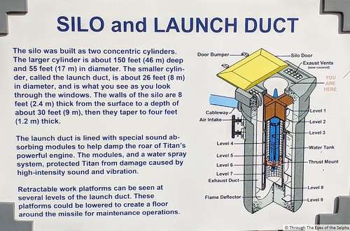
After watching a short video, we took a guided tour of the underground control center and saw the 103 foot tall Titan II missile in its underground silo.  IMG_20171113_142220IMG_20171113_142228

We had an excellent guide who gave an in depth description of the missile facility.  This was once an active intercontinental Ballistic Missile complex.  Of the Titan II sites in the U.S. weapon system, this is the only one not destroyed.  At one time there were 54 missiles sites, with eighteen each distributed over three locations (Little Rock, Arkansas, Wichita, Kansas and Tucson, Arizona).

IMG_20171113_142514

The Missile Silos Around Tuscon

IMG_20171113_142450

Site in 1962

IMG_20171113_142457

Site in 2012

The elevator into the underground silo was under maintenance so we took the 55 steps in and then back out, not too strenuous.  Anyone over six feet tall was required to wear a hard hat because we were entering low areas and they didn’t want to risk anyone injuring their head.  For sanitary reasons each hard hat had a hair net, giving the wearer an unusual look!  Bill didn’t seem to mind.  He is always such a good sport.IMG_20171113_131859

The Titan II is the largest ballistic missile developed by the United States.  It can carry a warhead of nine megatons, equal to nine million tons of TNT.  The amount of TNT needed to equal the explosive power of the Titan II warhead would require a train of 90,000 boxcars.  The train would be 1,534 miles long, stretching from Tucson to Lexington, Kentucky.  While we were in the launch command center the guide simulated what a launch would have been like.  It was sobering and rather scary to think what might have been.IMG_20171113_141158IMG_20171113_141150

During the Cold War the facility, and others like it, was manned twenty four hours a day, waiting for the command to launch.  While they waited, men and women worked keeping the extremely complex system of hundreds of electronic and mechanical systems which must interact perfectly with each other, safe and ready to fire. IMG_20171113_133240IMG_20171113_133246IMG_20171113_133313IMG_20171113_135335 IMG_20171113_135504

There was an accident at a Titan II missile site in Little Rock, Arkansas.  IMG_20171113_124920IMG_20171113_124954

A movie made for television, called “Disaster at Silo Seven” was filmed here.  Also in 1996 part of the movie “Star Trek: First Contact” was filmed at this facility.

The power of the Titan wasn’t all potentially devastatingly destructive.  When no longer needed as a weapon, the Titan also launched the Gemini Program’s astronauts into orbit, sent the Viking probes to Mars and launched Voyager into the outer solar system.  While it can be said the Titan missile prevented a possible catastrophic war with the Soviet Union, it also advanced the exploration of space.IMG_20171113_125143

After our tour we walked around outside.  We saw the cover over the missile which allows satellites from other countries to see the missile silo is inactive.  Our guide told us we had to explain to our potential enemies why we wanted to keep one of the missiles instead of destroying them all.IMG_20171113_141344IMG_20171113_141312IMG_20171113_14140320171113_141817IMG_20171113_125101

Bill was also excited to find an amateur radio antenna where ham radio operators can bring their radios and talk to people around the world using this very large antenna.20171113143704

Alamogordo, NM OCT 26, 2017

Leaving Lakewood on Thursday we headed west towards Alamogordo.  We again passed by the pumps pumping oil.  20171022_145029

We had to drive over the Cloudcroft summit, elevation 8,650 ft.  Due to the high elevation and the steep grade on the way down from the peak, we disconnected the car and I drove the car down the mountain.  I was able to snap a quick picture of Bill driving the RV through a tunnel on the way down.20171026_114759(0)

We arrived in Alamogordo and set up at the local friendly Elks Lodge where they have electric, water and sewer RV sites.  Alamogordo is home to the Holloman Air Force Base and much of the city’s industry is related to the Air Base and space travel.

After getting settled in we drove to the nearby New Mexico Museum of Space History. It is appropriate that the museum is here since this area of New Mexico is known as the cradle of America’s space program.  It was not the most extensive space museum we have ever been to, and some of the museum was under renovation and in disarray, but we enjoyed our visit.  IMG_20171026_13585920171026_14072320171026_140819

20171026_141214

This is the Elevator

On the grounds was the burial site of HAM, the first “Astrochimp”.  (Previously dogs and other animals had been launched by Soviets and NASA as merely passengers.) HAM was launched in a Mercury capsule on January 31, 1961.  Three months later the first manned flight was launched into space with Alan Shepard becoming the first American in space.   IMG_20171026_142931IMG_20171026_14294420171026_142947

We both enjoyed the Star Trek collection.20171026_150627IMG_20171026_151133IMG_20171026_151047

 Bill was especially interested in the Daisy Track.  It was used from 1955 to 1985 and was converted from rocket to air powered sled track. It was used to study the effects of acceleration, deceleration and impact on the human body of different equipment systems.  It was used for biological and mechanical research and testing for NASA’s Mercury space flights and the Apollo moon landings. It was used to test the idea of seat belts for automobile use.IMG_20171026_151629IMG_20171026_152437IMG_20171026_152827IMG_20171026_152907IMG_20171026_153025

Thursday evening was Wing Night at the Elks and we went over and had some wings in hot sauce, very hot sauce!

IMG_20171027_132702Friday we drove to White Sands National Monument.  Here, rare gypsum sands form beautiful white dunes that rise up to sixty feet above the Tularosa Basin floor at the northern end of the Chihuahuan Desert.  How were they formed?  Basically when the Permian Sea retreated millions of years ago, it left behind deep layers of gypsum fields.  Mountains rose and carried  the gypsum higher. The dunes were created when rain and melting snow dissolved gypsum from the surrounding mountains and carried it into Lake Lucero.  Desert heat evaporated the water, causing gypsum crystals to form.  Dry southwest winds exposed the crystals, eroding them into sand size particles that were blown to form the dunes.  

Today, wind, snow and rain continue the process.  Inches below the surface is water which prevents the dunes from blowing away.  At 275 square miles, White Sands is the world’s largest gypsum dune field.  It is truly like no other place on earth and one of the world’s great natural wonders.  People are allowed to go dune sledding here.  President Herbert Hoover declared it a national monument in 1933.  

We saw an interesting movie in the Visitors Center on how the dunes were formed and are ever changing.  Of particular interest was a description of how the animals such as lizards and rodents have adapted to the harsh, white environment by evolving to a white color to camouflage themselves from their enemies. IMG_20171027_132756 

This can be a surprisingly dangerous environment where it is easy to get lost and lose your bearings in all the whiteness.  A couple years ago a family visiting from France became disoriented on one of the trails on a hot day.  They had failed to bring enough water with them on the hike.  The parents died and their son survived because the parents gave their water to their son.  IMG_1517IMG_1519IMG_1521IMG_1522IMG_1526IMG_1532IMG_1544IMG_1552

We walked on a couple of the easier trails.  In the parking lot of one of the trails we noticed a vehicle with Virginia license plates so of course we had to stop and talk with them.  They were from Henrico County and had been traveling full time in their RV for four months.  We stood in the parking lot and chatted with them for about an hour, sharing our experience over the last four years.  Always excited to meet someone from my birth state.  We exchanged contact information so hopefully we will meet up with this nice couple sometime down the road.IMG_1557IMG_1563IMG_1553

Nearby is White Sands Missile Range where the Trinity Site is located.  It was here on July 16,1945 the first atomic bomb was detonated.  From 1945 to 1949 the German V2 rockets and their engineers assembled and tested their rockets here. In the 1960’s, testing for the lunar module engines that propelled Apollo astronauts off the moon’s surface was done here.  Today the facilities are used for radar, laser and flight research.IMG_20171026_145557

On Saturday Bill helped some men from the Elks replace some electrical power cables.  Some of the electrical outlets at various campsites were not working.  When the men came on Saturday morning to fix them, Bill went out to ask if they needed help.  They accepted his offer so he spent several hours helping them pull power cables underground. Their next step will be to connect up the RV sites to the new cables.

Next up: Willcox, Arizona

Albuquerque Part 2, NM OCT 14, 2017

As I mentioned in the previous blog, Bill’s college friend Peter and his wife Beth flew in from Florida and joined us for several days in Albuquerque.  Besides the Balloon Fiesta there were other things to enjoy in the area.00000IMG_00000_BURST20171014150352_COVER
One afternoon we went to the National Museum of Nuclear Science and History.  This is the country’s official museum for the history and science of the Nuclear Age.  They have replicas of Little Boy and Fat Man, the world’s first two atomic weapons.

IMG_20171012_151508

The Trinity Test Tower. At 5:30 a.m. on July 16, 1945, Los Alamos scientists detonated a plutonium bomb at a test site located on the U.S. Air Force base at Alamogordo, New Mexico, some 120 miles south of Albuquerque.

They have exhibits on atomic theory, the Cold War, pioneers in nuclear science, uranium processing, facts about radiation and nuclear medicine/ medical technology.  We saw a movie about the Manhattan Project in Los Alamos about the design and testing of the nuclear bomb.  Outside were several planes, rockets, bombs and missiles.IMG_20171012_13231320171012_153936PANO_20171012_160821IMG_20171012_160938IMG_20171012_16101220171012_153807IMG_20171012_153345IMG_20171012_153053IMG_20171012_135248

Another day we all went into Old Town Albuquerque for lunch and wandered through some shops.IMG_20171014_152926IMG_20171014_150438IMG_20171014_150505IMG_20171014_132808IMG_20171014_132827

Bill and I visited Albuquerque in May, 2015.  You can read about our visit here. https://dianeandbill.selph.info/?p=4440

It was fun to catch up with the Wienermobile outside Peter and Beth’s hotel!20171012_130750

Many of you have commented on how much you enjoyed the Balloon Fiesta pictures in the last blog. There were way too many pictures to post in one blog.  Here is a link to more Balloon Fiesta pictures if you would like to see more. https://www.flickr.com/gp/lrun/Qw2399

Next stop: Valley of Fires, New Mexico for some rest and relaxation