After an overnight stop in Deming, New Mexico, we said a fond farewell to New Mexico and hello to Arizona. We really enjoyed our two months in New Mexico and made many great memories, but the weather was getting colder and it was time to move on to warmer weather. We crossed over the Continental Divide between Deming and Lordsburg, New Mexico, elevation 4,585 ft. Unfortunately we passed by the sign too quickly to snap a picture.


We knew for sure we had entered Arizona when we started seeing many signs on Interstate 10 warning of potential dust storms. It seemed every few miles there were yellow dust storm warning signs followed by signs with advice on what to do if you encountered a dust storm. 
Another way we knew we were near Mexico was when we passed through a border patrol checkpoint on I-10, even though we were really not that close to the border. They photographed the vehicle as we slowly passed and the border patrol agent waved us through. We didn’t even have to come to a stop.
Our first stop was in Willcox where we stayed three nights at another nice Elks Lodge with electric and water hookups. Willcox has a population of just over 3,700, a nice little town. Cattle raising is important here as well as the cultivation of apples, peaches, pistachios, onions and tomatoes. Willcox is also known for its vineyards.
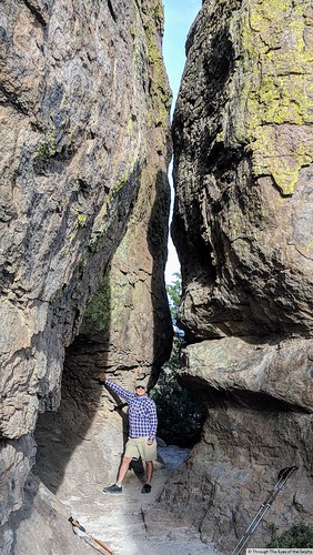
On Tuesday we made the forty-five minute drive to Chiricahua National Monument. This area is also called “Wonderland of Rocks” and was established as a monument in 1924 to protect the rocks. It exceeded our expectations and definitely had the WOW factor! These lands were once owned by the Chiricahua Apaches who were led by the great Cochise. Cochise led the Native American resistance to the white man’s advances during the 1860’s.
Twenty-seven million years ago violent eruptions from a nearby volcano covered the area with white hot ash and formed a twelve mile wide caldera. The ash cooled and fused into an almost 2,000 foot layer of rock. Over time erosion sculptured the rock into odd shaped rock pillars.
We stopped by the Visitors Center located in Bonita Canyon and saw a short movie on the area.
We drove the eight mile scenic drive where the rocks at times towered above us. 


We also took two hikes, both on rocky paths and we were glad we had our walking sticks. 


The views were amazing and reminded us of the magnificent national parks in Utah. We especially enjoyed the balanced rocks and the grottoes, which are small cave like formations.


Next stop: Benson, AZ
