Category Archives: National Park or Forest

National Park or Forest

December 10, 2013 Tucson Mountain Park

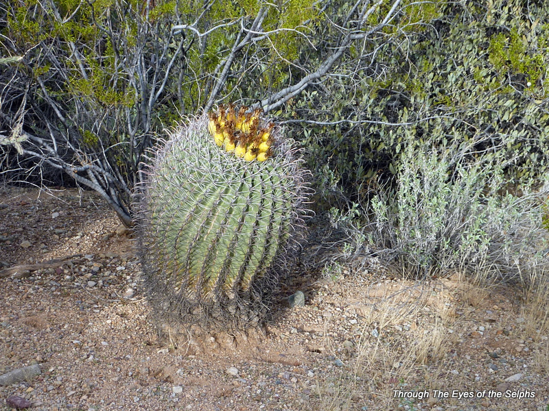
We arrived at Gilbert Ray Campground in Tucson Mountain Park and immediately fell in love with this campground. 3-P1030373 14-P10304112-P1030371 The campground was not as deserted as we expected, but we still had our pick of campsites.  After choosing one with a beautiful view of the mountains and saguaros, we quickly set up and headed to the nearby Saguaro National Park Visitors Center.  We watched a movie there on the plants and animals of the desert.  We have watched movies at many visitors centers in the past, but this one had an amazing ending.  After enthralling us with the sights and sounds of the 1-P1030364desert, they ended the movie by having the screen raise and the huge drapes open to show a breathtaking view of the desert outside.  it was a very dramatic way to end of movie.  I wish I had the words to express the affect it left on us.  Above all else, it left us with an appreciation for how we as visitors to to the desert, need to respect and care for such an amazing resource entrusted to us.  After the movie and touring the rest of the visitors center we attended a talk on desert life given by one of the park volunteers.  We ended the day by taking the scenic Bajada Loop Drive.  That evening the Space Station was visible overhead and we heard coyotes howling.

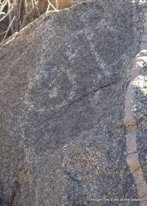
Our second day in the desert park we wanted to do some hiking and additional scenic driving.  We hiked the Desert Discovery Trail where we learned more about desert plant and animal life.  We then hiked to the top of Signal Hill to see some petroglyphs which were created by the prehistoric Hohokam people more than a thousand years ago.  I kept telling myself the rattlesnakes had hibernated for the winter!  02-P1030386 04-P1030398
05-P103040006-P1030401 07-P1030403 13-P1030410

09-P1030405

08-P103040410-P1030406

After lunch at a picnic table made by the Civilian Corps men many years ago, we went back to the Visitors Center for a talk about the history and life of the Hohokam people.

We spent the rest of the afternoon grabbing a geocache in the desert and then rode along Picture Rocks Road which included narrow Gates Pass and some amazing scenery. 15-P1030419 3-P1030373 4-P1030376 5-P1030377 6-P1030378 When we arrived home we enjoyed sitting outside watching the sunset and listening to the coyotes.  They were especially vocal tonight!  16-P1030444 17-P1030445

December 2, 2013 Deming, New Mexico

We crossed the border of Texas into New Mexico and stopped at the welcome center to pick up some tourist information and grab a quick geocache….our first in the desert!  1-P1030231 Not long after crossing the state line into New Mexico we had our first border patrol stop on Interstate 10 which was quick since they just waved us through. We stayed at an Escapees park called Dream Catcher RV Park.  One thing we noticed so far about RV parks in west Texas and New Mexico is it is very much like camping in a parking lot…wide open spaces with no trees or grass, just hookups for your RV.  This is something that has taken some getting used to! The next day we decided to drive the two and a half hour drive to see the Gila Cliff Dwellings in Gila National Forest.  06-P1030265The signs promised us a scenic byway, and we were not disappointed! 02-P1030248  Not long after leaving the Deming city limits we encountered another border patrol stop.  This time they made us stop, and they looked through the window of our car, asked if we were both US citizens, and then wished us a nice day and we proceeded on our way.    We loved seeing windmills against the mountains.  01-P1030245The views were amazing as we climbed over 8,200 feet along narrow roads with sharp curves and hairpin turns.  03-P1030246 05-P1030263    10-P1030275 08-P1030271 09-P1030272 10-P1030275       We were more than a little surprised to see snow on the mountaintops and along the side of the road!   We arrived at the trailhead to the cliff dwellings.  The ranger told us they had recently had 4 inches of snow, and while the trail was clear, there were some icy patches along the trail, so we decided to use our trekking poles.  We purchased the trekking poles last fall to help with steep and uneven terrain, and we have certainly enjoyed using them and have found them to be very helpful.  We really recommend them to anyone who does much walking or hiking.  We did not find the trail particularly difficult going up, but coming down was another story since that side of the trail does not get much sun and the trail was very icy in some places. 25-P1030303 Certainly not what we expected to encounter when we left home that morning, but the snow and ice all added to the excitement of the day.  It had been some time since we had last seen snow! The cliff dwellings were amazing and definitely worth the drive over and back.  We were told by one of the park rangers that this is the only cliff dwellings in the country that actually allow you to go inside the dwellings and not just view them from a distance.  Archeologists believe the Mogollon people lived in the dwellings from the late 1270’s to 1300 AD. 13-P1030282 They think they lived here for such a short time because a severe drought affected their ability to farm and they moved on.  The cliff dwellings have approximately 40 rooms built inside several natural caves in the canyon.  We did see some pictographs but many have faded over time. 11-P1030279 12-P1030280 14-P1030284 After the Mogollon left, it appears no one lived in the region for over 100 years until the Apaches migrated there around 1500 AD.  Geronimo was born near the Gila River in the early 1820’s.  26-P1030306  In 1878 a prospector and miner H. B. Ailman discovered the cliff dwellings.  By 1884 when archeologist Adolph Bandelier arrived, looters had stolen many of the artifacts and burned the roofs of some of the cave dwellings.  In 1907 President Theodore Roosevelt proclaimed the area a national monument in an effort to prevent further destruction.         16-P1030286 17-P1030289 18-P1030290 19-P1030291 20-P1030292 22-P1030293 23-P1030294 21-P1030296 24-P1030298 15-P1030300                                                                                         We had planned on leaving Deming the next day, but Tuesday night we received a high wind advisory on our phones for difficult driving conditions along Interstate 10 for high profile vehicles like RVs.  Since we had seen many signs throughout west Texas and New Mexico along the interstate warning of cross winds and low to zero visibility due to blowing sand, we decided to heed the warning and stay in Deming another day.

November 8, 2013 Houston, Texas

On the way to Houston we stayed one night in the Sam Houston National Forest at Cagle Campground.  What a nice campground!  We had a large site with a concrete pad and full hookup.  This is not what is usually available in a national forest campground!

We arrived in Houston 01-IMG_20131108_195417for a 5 night stay at a private campground about 13 miles outside of the city of Houston.  It was a nice site with a concrete pad and full hookup, but without the space, trees and privacy we found at the national forest campground.  It also had some traffic noise from the interstate close by.  It seemed more like a concrete jungle after the state parks we have grown accustomed to camping in.  After dealing with the mud and dirt from all the rain in Dallas earlier in the week, the concrete pad was nice, but we would have really liked some trees and grass!

On Sunday we drove into Houston to visit our friend Priscilla and her husband Roy.  We met Priscilla when we lived in Northern Virginia and she is now living in Houston.  It was SO good to spend time with them!  We had a great meal at a barbecue restaurant and after eating they gave us a nice tour of Houston and Rice University campus.  1-P1030167


02-P1030171Monday we drove 45 minutes to Brazos Bend State Park to do some geocaching and orienteering.  It is hard to find permanent orienteering courses and we were pleasantly surprised to see they had one in this park.  While driving in we noticed signs saying the area had alligators and venomous snakes.  We drove to one lake in the park and walked around and to our disappointment we didn’t see any alligators.  We pretty much decided we wouldn’t see any that day because the lakes were way down from the ongoing drought in Texas.  We decided to find two geocaches near an observatory in the park.  As we parked our car we encountered two elderly ladies who calmly and nonchalantly told us they had seen an alligator on the trail near a small bridge over the water.  We thanked them for telling us and thought they surely had seen an alligator in the distance sunning on a far bank.  To our astonishment as we walked down the path we came upon a huge alligator estimated to be 7 or 8 feet long five feet away from us.   04-P1030175We figured if those two ladies could get by him alive, so could we, so Bill told me to give him the camera in case we had to start running.  He took my hand and led the way as we slowly and carefully walked past the alligator.  If truth be told, he had to slightly pull me past the alligator because my feet were not so eager to walk past the creature.  We found our geocaches and then headed back down the trail thinking we would once again inch our way past Ally Alligator.  To our amazement, in the short time we were gone, the alligator stretched his body across the trail, blocking our way.  06-P1030182Since it didn’t look like he was in any hurry to get on his way, we had to find another trail back to the car.  Bill and I both agreed this was the closest we had ever been to an alligator of that size….a once in a lifetime experience when you least expect it!  Never thought we would leave Florida to have a close and personal encounter with an alligator in Texas!  On the way to the car we saw another huge alligator on a small island in the water and a little baby alligator sunning on a rock in the water.  We also saw many turtles, a bunny, and a lot of birds.  05-P1030179 09-P1030185 07-P1030183 10-P1030186 08-P1030184


While orienteering later in the day we saw another 7 foot alligator on a bank across the lake, but he dove into the water before we could get a picture so we had to be satisfied with one of him in the water as he swam away.  11-P1030188We came home tired and happy from our fun and exciting day in the park!

August 8, 2013 Marquette, Michigan

On the way to our next stop in Marquette, Michigan we decided to stop at Oswald’s Bear Ranch near Newberry. They rescue bear cubs from around the United States and give them a place to safely grow up and live. It is against the law in Michigan to breed and buy black bears.

01-IMG_20130808_130150 07-P1020435_20130808 06-P1020432_20130808 04-P1020401_20130808 05-P1020420_20130808 03-P1020392_20130808 02-P1020378_20130808 08-IMG_20130808_214401 09-IMG_20130808_124038

As we drove toward Marquette, we couldn’t help but notice the breathtaking views of Lake Superior.  We pulled into a private campground and were directed to a campsite overlooking Lake Superior.  We were hesitate to take the site because of the traffic noise, but the view won out over any hesitations.  We noticed immediately the campground was not at all as advertised on their website.  The website depiction must have been from 10+ years ago, but we had prepaid for reservations and again, the view won us over.

13-IMG_20130808_213448 11-20130808_210603 12-20130808_210632(0) 10-20130808_210439

We came to realize that first night that the water had a very strange smell….much like iron and some such minerals.  The water continued to be a source of concern during our stay, but we had several water filters on the coach and used a Brita water pitcher, but still we were uneasy.

Now for the GREAT part of our time near Marquette.  The highlight of our time here was without a doubt the ferry ride to view the cliffs of Picture Rocks.  There are 15 miles of sandstone cliffs which are up to 200 feet above lake level.  The colors are caused by large amounts of mineral in the rocks.  The water evaporates leaving streaks of colors.  The red color comes from iron, pink and green from copper, yellow and brown from limonite, and black and white from manganese.  As they say, a picture is worth a thousand words….

24-IMG_20130810_195532 22-IMG_20130810_223221 11-IMG_20130810_223125 20-IMG_20130810_220214 04-IMG_20130810_184322 23-IMG_20130810_190123 14-P1020488_20130810 16-P1020497_20130810 17-P1020499_20130810 18-P1020512_20130810 21-IMG_20130810_222930 19-IMG_20130810_215847 13-P1020487_20130810 12-P1020476_20130810 10-P1020475_20130810 09-P1020474_20130810 08-P1020467_20130810 07-P1020462_20130810 06-P1020457_20130810 05-P1020455_20130810

Before we caught the ferry we spent the morning in Picture Rocks National Lakeshore Park where we hiked Munising Falls which was very easy, and Mosquito Falls which was quite a challenging hike over roots, rocks and trails muddy from the previous days rain.

01-P1020438_20130810 02-P1020444_20130810 03-P1020440_20130810

Another day we decided to go to Presque Isle Park, a beautiful peninsula that juts out into Lake Superior, to do some sightseeing and geocaching.  We found this to be a great park with some interesting and challenging geocaches, as well as some gorgeous views!

3-IMG_20130809_170016 1-IMG_20130809_154930 4-IMG_20130809_173303 2-IMG_20130809_165958

July 24, 2013 Cadillac, Michigan

On our way to Cadillac we decided to stop in Grand Rapids, Michigan and visit the Gerald Ford Presidential Library and Museum.

1-IMG_20130724_115014

.

2-IMG_20130724_115100

.

3-IMG_20130724_115232

.

6-IMG_20130724_115542

I included this plaque because I thought it was interesting that Ford was the first president to visit Japan.

4-IMG_20130724_132226

Replica of the Oval Office during Ford’s presidency.

5-20130724_141252

Ford is the only President and Vice-President to ever achieve the level of Eagle Scout. Here are some of his boy scout mementos, including his merit badge sash.


After spending a good part of the morning at the Ford museum, we arrived for a 5 night stay at a private campground called Camp Cadillac.  One of the highlights of our stay here was a visit to Sleeping Bear Dunes National Lakeshore Park which was about an hour drive from Cadillac.  In 2011 Sleeping Bear Dunes National Lakeshore was voted the most beautiful place in America in a poll conducted by Good Morning America.  We took a self guided tour around the park and rode our bikes along a paved bike trail in the park.  What a beautiful place!

13-IMG_20130725_165003

The tiny dots are people climbing the dunes on their hands and knees!

02-20130725_154804 05-IMG_20130725_164816 07-IMG_20130725_164910 04-20130725_154910 08-IMG_20130725_164903 12-IMG_20130725_164947 11-IMG_20130725_164829 06-20130725_154956 14-IMG_20130725_155204 03-IMG_20130725_155422 10-IMG_20130725_155529 09-20130725_165031 01-IMG_20130725_161205 15-IMG_20130725_194122 16-20130725_174814-1


On another day we drove to Traverse City.  It was cold and threatening rain so we decided not to bike ride, but did visit a lighthouse and found ourselves on the 45th parallel, halfway to the North Pole!

1-20130727_130906-1