Category Archives: State Park

State Park visited or camped here

August 29, 2014 Weed, California

We spent a relaxing four days at Collier Memorial State Park near Chiloquin, Oregon.  We had been without internet or good cell phone service for over a week so we spent lots of time working on blog posts, doing paperwork and planning our fall and winter itinerary.  It takes time to research places to stay and make reservations.  Now that summer is over the parks will not be as crowded, but there is always the holidays to plan for, and the earlier the better.  There are many snowbirds that come down from Canada and snap up spots in the nicer RV resorts.

Our second day at Collier we began to notice smoke in the air from four surrounding Oregon wildfires.  Even though the fires were not that close, we could definitely smell the smoke.  The smoke continued to worsen during our stay and when we left on August 29th for Weed, California, there was hazy smoke in the air.

We had a wonderful time in Washington and Oregon and the time passed by so quickly.  Today we entered California again.  We passed through farmland with cattle grazing and the beginning of irrigation and crops growing in the fields.  We made a stop in Klamath Falls, Oregon at a Walmart to stock up on supplies and food.  We wanted to take advantage of this last Walmart in Oregon since Oregon has no sales tax.

As we crossed the border into California we had to stop at an agricultural checkpoint where we were asked where we were coming from and if we had any fruits or plants.  Bill told them we had just bought a bag of apples at Walmart in Oregon and they told us we could go.  We thought as we traveled further south the smoke would begin to dissipate, but if anything it got worse.  For most of our two hour trip the visibility was only about two miles.

We checked into a small, no frills campground in Weed, California (population 2,900), for a four night stay during the Labor Day holiday.  Weed is a little spot in the road but we wanted to stay away from the craziness of crowded state and national parks during the final summer holiday.

We ventured out to Main IMG_2136Street to visit the post office.  We did a little geocaching and it is always amazing to find some unexpected sites in these small towns!  We came across this Alaskan totem pole where a geocache was located.  Turns out this totem pole  is at the beginning of Highway 97 which is the beginning of the Alaskan-Canadian Highway.  If you stayed on Highway 97 you would eventually pass through Canada into Alaska.  There is another totem pole at the end of the highway in Alaska.

Another wonderful find while geocaching was the “Living Memorial Sculpture Garden” located about fifteen miles from our campground on Highway 97.  This garden, located with a view of Mt Shasta in the distance, was founded in 1988 by a group of Siskiyou IMG_2152County veterans to celebrate veterans of conflicts from the Revolutionary to the present.  Dennis Smith, a Vietnam veteran, is a metal sculptor whose works are displayed in the garden.  There is also a Memorial Wall and every Memorial Day and Veterans Day, new names are etched on the wall and read aloud. At the entrance to the area is “The Peaceful Warrior”, a lone figure with one arm raised,  representing those who love peace and will fight aggression to preserve that peace.  This sculpture honors those willing to step forward when asked to do so.  There are nine other sculptures in the park where we walked through a labyrinth to see them.  We took pictures of some of our favorites to share in the blog.  “Those Left Behind” is a  female figure accepting the American flag.

Those left behind

Those left behind

“Who can repay those who have lost loved ones in combat?  What on earth can compensate them for the loss of life?”  “The Greatest Generation” sculpture depicts the second raising of the flagIMG_2141 on Mt Suribachi, Iwo Jima, on February 23, 1945.  “The Nurses” sculpture honors nurses, Navy IMG_2151corpsmen, Army medics, doctors and pharmacists  who bring healing.  “The POW-MIA” sculpture was the most moving, showing a soldier in a cage.  Outside the cage is a metal arch where  IMG_2148 over the years people have left POW and MIA bracelets, wreaths, flags, flowers and personal notes.

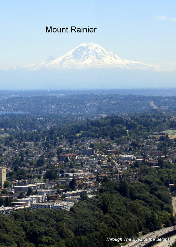
Our main reason for stopping in Weed was to see Mount Shasta, the largest composite volcano in the Cascades and the second highest peak in the Cascades, with only Mt Rainier being higher.  When we arrived in Weed, Mount Shasta was nowhere in site due to the smoke and haze from the wildfires.  We hoped the visibility would improve during the four days we IMG_2144  were there and on the day before we left the smoke cleared enough for us to get some fairly good pictures. IMG_2166

North face of MT Shasta and MT Shastina

North face of MT Shasta and MT Shastina

South face of MT Shastina and MT Shasta

South face of MT Shastina and MT Shasta

IMG_2177 We drove the fourteen mile Mount Shasta Scenic Mountain Drive which took us halfway up the mountain to an altitude of 7,900 feet. IMG_2155  Many mountains are considered to be sacred places, especially to Native Americans, but we found Mount Shasta to be considered one of the most sacred mountains in the world.  There are small sacred communities near the mountain offering spiritual energy and peaceful experiences as well as spiritual guidebooks of the area.  At one viewpoint we found many sacred circlIMG_2164es made of rocks.  We took a hikeIMG_2165 on the Panther Meadow Trail which would have been prettier in the spring when the wildflowers were in bloom.

Trailhead for MT Shasta starting at 7,900 FT

Trailhead for MT Shasta starting at 7,900 FT

IMG_2163
Bill spent the rest of Labor Day laboring with jobs around the RV like washing the tow car, checking the water in the RV batteries and cleaning the tanks.


August 19, 2014 La Pine, Oregon

We didn’t have a reservation at La Pine State Park which is unusual for us during the summer tourist season, but we decided to take a chance since it was the beginning of the week and not the weekend. The camp host showed us several sites to choose from and we happily settled into a nice pull through site with full hookup.

This turned out to be such a fascinating area to explore. We had no idea we would explore a lava tube (cave) and see huge cinder cones and lave flows in Oregon!

We were eager to explore Newberry National Volcanic Monument, established in 1990. IMG_1996 IMG_1994 IMG_1999 IMG_1997Newberry Volcano, central Oregon’s sleeping giant, has a lava flow covering almost 1,200 square miles (about the size of Rhode Island), making it the largest volcano in the Cascades chain. Unlike other volcanoes in the Pacific Northwest, this volcano is a composite volcano with dramatic lava flows that were very fluid during the eruptions, making it similar to volcanoes you would see in Hawaii. Newberry has as many as 400 volcanic vents around its slopes. Newberry Volcano has a large volcanic depression called a caldera. Scientists think the violent eruption which caused the caldera and occurred about 75,000 years ago, is responsible for volcanic ash deposits as far away as the San Francisco area. Newberry Volcano has been erupting over 400,000 years with the last eruption occurring about 1,300 years ago. Geologists say that while it is a sleeping giant, it could reawaken at any time and they monitor it closely.

We drove to the Newberry Caldera and stopped by the Lava Lands Visitors Center which included exhibits and 3-D topographic models of the volcano. We picked up a free pass to drive to the top of the Lava Butte Cinder Cone. The parking area at the top is very small so they limit traffic to 10 cars at a time. The pass gave us thirty minutes to explore the cone. The view at the top was magnificent. This cone is 7,000 years old and the lava flow from this cone once dammed up the Deschutes River. IMG_1991 IMG_2001 IMG_2007 IMG_2011

We drove to an Obsidian Lava Flow and hiked a short distance to stairs that took us to the top IMG_1998 IMG_2041 IMG_2039 IMG_2035 IMG_2033 IMG_2031 of the lava flow. It was amazing to see the huge piles of lava rocks. What makes this lava flow special is the presence of large amounts of obsidian rock (black glass). I spoke with a lady who is an Oregon native. She said there used to be even more obsidian rock many years ago but people over the years carried them off.   Today there are signs warning it is against the law to remove any rocks. The lady also said that there is only one other obsidian lava flow in the world, and that is in Russia.

We read there was a lava cave where we could walk inside a lava flow. So while in the area we went to the Lava River Cave. This is one of the longest, uncollapsed lava tubes in the IMG_2012 IMG_2013 IMG_2015 IMG_2023 IMG_2025

We could see our breath!

We could see our breath!

IMG_2026 Northwest. The cave was once the pathway of an underground stream of molten lava. We knew the cave was going to be cold and dark, so we took jackets and flashlights. We entered the cave and immediately started to descend. The cave stays at a constant temperature of 42 degrees and it was very dark, even with flashlights. We picked our way slowly over rocks and uneven surfaces, occasionally coming to narrow flights of stairs taking us higher and further into the cave. The cave is a mile long and I found it more claustrophobic and unsettling than Bill. I don’t tend to be claustrophobic, but the dark lava walls and rocky uneven surface made me uncomfortable. There were quite a few tourists in the cave and I wondered how those walking with flipflops and using their cameras for light ever made it back out safely.  I read the forest service is working on improvements to the cave with boardwalks over the uneven rocky surfaces and new stairways to make it more accessible to everyone. Hopefully this can be done without destroying the natural setting of the cave. There are bats living in the cave but we didn’t see any.

While at La Pine we got our first taste of cold weather. We awoke one morning to the sound of the heat pumps struggling to keep up and discovered the outside temperature was 38 degrees. Yikes! It wasn’t that long ago we were complaining about the heat. Now instead of searching for a campsite with shade, we were hunting sites with full sun! IMG_2004 IMG_2005 IMG_2006

August 11, 2014 The Cove Palisades State Park, Culver, Oregon

One forgotten Mt Hood picture!

Close-up view of one of Mt Hood's glaciers, very cold but melting

Close-up view of one of Mt Hood’s glaciers, very cold but melting

We reluctantly left Moro and may have stayed for another day if it hadn’t been for the dreadful heat.  We were headed south and sought out a campground with some shady campsites.  We found The Cove Palisades State Park and after finding out they had several spots available we drove to the campground and chose the shadiest spot we could find.  We didn’t worry about trees blocking the satellite TV; with temperatures approaching 101 degrees, we just wanted some shade!

This was just a one night stay and we wanted to see some of the park, so after setting up we hopped in the car.  This park actually has two campgrounds.  We atayed in the one at the top of the canyon which was cooler, had more grass and shade and was closer to the entrance.  We wanted to see the other campground which was a five mile drive down into the canyon.  Once we saw the road we were really glad we didn’t stay there because the road was very steep and our car thermometer went up five degrees in the canyon.  We loved the views of the canyons walls which surrounded a lake and we crossed a bridge as the road wound through IMG_1920 IMG_1916 the canyon and passed an impressive waterfall. IMG_1915 We came to one area in the canyon where we found a geocache at a site where there was a petroglyph.  IMG_1923 IMG_1922

The next day we headed to Redmond, Oregon where we will be attending an FMCA (Family Motor Coach Association) Rally.  They are expecting well over 3,000 RVs to attend this rally with seminars, vendors and entertainment to keep us very busy.  As we pulled out of our campground we had a hazy view of Mt Jefferson.

Mt Jefferson from our campsite

Mt Jefferson from our campsite

 A zoomed view of Mt Jefferson from our campground

A zoomed view of Mt Jefferson from our campground


July 7, 2014 Federal Way, Washington, part 3

Bill also visited the Living Computer Museum in downtown Seattle, a small museum with a computer collection assembled by Microsoft co-founder Paul G. Allen.  The collection reflected milestones in the evolution of computers and how people use them.  Paul Allen wanted to preserve the history that put he and Bill Gates on the path to founding Microsoft.

All of the computers are operational and are hands-on for the museum goers.

Letter from Paul G. Allen
It is possible that no other technology on earth has so continually renewed itself as computer technology. Advances in this field arrive in such swift succession that even the software and hardware of a few seasons ago are considered obsolete. The decades-old computers and software in this collection, therefore, are truly worthy of our preservation and study – both for the cutting-edge innovations of their day as well as for their historical significance.The Living Computer Museum also fulfills my hope that the achievements of early computer engineers aren’t lost to time. I wanted to provide a website and repository that recognized the efforts of those creative engineers who made some of the early breakthroughs in interactive computing that changed the world.

IMG_1308

This is a paper card punch that Bill used during college to create computer programs

This is a paper card punch that Bill used during college to create computer programs

Bill used this Data General Nova computer and a Teletype to develop F-4 fighter jet simulation programs

Bill used this Data General Nova computer and a Teletype to develop F-4 fighter jet simulation programs

Bill used paper tape for a short time to program computers from 1975 to 1984

Bill used paper tape for a short time to program computers from 1975 to 1984

Paul Allen and Bill gates in 1968 at a Seattle school

Paul Allen and Bill gates in 1968 at a Seattle school

This is a typical 1977 memory module that would hold 8,000 characters

This is a typical 1977 memory module that would hold 8,000 characters

It use to take a crane to move one computer

It use to take a crane to move one computer

This is the inside wiring of a Control Data computer from twenty years ago

This is the inside wiring of a Control Data computer from twenty years ago

The very popular Radio Shack TRS-80

The very popular Radio Shack TRS-80

This oversized box is a 3D printer making plastic parts

This oversized box is a 3D printer making plastic parts


We stopped at an REI in Seattle, their flagship store, for a little shopping.

This REI store has everything for the outdoors!!!

This REI store has everything for the outdoors!!!


Bill was excited to visit the Microsoft Campus and tour their Visitors Center where they have hands-on exhibits starting with their first personal computer to their latest innovations. It was interesting to read about the history of Microsoft.20140708_162106

Bill Gates in the lower left and Paul Allen in the lower right

Bill Gates in the lower left and Paul Allen in the lower right

Microsoft has many products on display in their visitor center

Microsoft has many products on display in their visitor center


Lastly we visited the Boeing Future of Flight and Aviation Center in Everett, Washington north of Seattle. We explored the museum and then took a tour of the Boeing factory. They bused us from the museum over to the factory which is the largest building in the world by volume. It comprises 472,000,000 cubic feet, which equates to 75 football fields. We were taken to two separate areas of the building. In both areas we entered a underground tunnel and walked a third of a mile before being taken up on a freight elevator to a catwalk where we could look down and see the airplanes being built. We had an excellent, enthusiastic guide who did a great job explaining what we were seeing. We saw their new Boeing Dreamliner 787 which is being unveiled in England at the end of this month. We also saw how they are now building aircraft with the latest technology, including the use of composite materials which make the aircraft lighter and faster. It was an amazing experience!  One note of explanation:  we were not allowed to take cell phones, cameras, purses, etc on the tour, therefore, no pictures inside the factory!  All the pictures you see here were taken in the Boeing Future of Flight Museum in a separate building from the factory.

20140712_112840

Boeing's technology

Boeing’s technology

20140712_114616

HK36 Fuel Cell Electric Airplane Demonstrator

HK36 Fuel Cell Electric Airplane Demonstrator

HK36 Fuel Cell Electric Airplane Demonstrator

HK36 Fuel Cell Electric Airplane Demonstrator

20140712_115021

July 7, 2014 Federal Way, Washington, part 2

We took a tour of a small museum called the Herbert H. Warrick Jr. Museum of Communications. The museum basically shows the history of the telephone and all the equipment that makes it work. Bill wanted to see this museum because 25 years ago he worked for a company where he validated telephone switches and he was curious about whether they had any of that equipment on display. Exhibits from 1876, starting with a model of Alexander Graham Bell’s first successful telephone to the modern phones of today were on exhibit. A volunteer gave us a tour and he was an excellent guide whose knowledge and enjoyment of the subject was evident. The amazing thing was that virtually all the exhibits are operational. It was truly a one of a kind museum!

A Step by Step switching system designed in 1889 and is being used today

A Step by Step switching system designed in 1889 and is being used today

Panel switching system designed in 1914 to route calls and provide dial tone

Panel switching system designed in 1914 to route calls and provide dial tone

20140708_111056

This is an AT&T washing machine - they tried to build everything

This is an AT&T washing machine – they tried to build everything

This is how phone lines were strung on individual insulators

This is how phone lines were strung on individual insulators

This is the pay-scale from 1899 at the phone company

This is the pay-scale from 1899 at the phone company

Radio amateur equipment

Radio amateur equipment

July 7, 2014 Federal Way, Washington, part 1

We prepared to leave Mount Rainier and head north towards Seattle.  While we enjoyed our time “off the grid”, we were looking forward to once again having cell phone service, internet, and yes, satellite TV.  This is not a vacation but a lifestyle, so we need internet access to check credit card activity, pay bills online, and stay in touch with family and friends.  We also missed having access to news and weather via TV.

Our last day at the campground we met a couple from Holland.  They flew into San Francisco, rented an RV from Camping World, and are now exploring the western U.S.  They plan to be in Vermont in time to see the leaves change in the fall and then travel down the East Coast to Key West before returning the RV in Miami and flying home.  He flew fighter jets at one time and was a pilot for British Airways.  It was interesting talking with him but also alarming to hear him say it is so cheap for them to do this in the U.S. but would be much more expensive for us to do the same thing in Europe because their pound is worth so much more than our dollar.  At one time they were almost even in value.  So far we have met couples from Australia, Germany and Holland RVing around the United States.

On our way out of the park we noticed a “Volcano Evacuation Route” sign.  Now we have seen “Hurricane Evacuation”, Tsumani Evacuation” and “Volcano Evacuation” route signs!  20140707_115148-1After a short trip north we arrived at Dash Point State Park.  The sites were pretty close together but we had good cell phone service, satellite TV, and it was a short drive to Seattle where we planned to do some sightseeing.

Instead of the Space Needle we decided to go to the Sky View Observatory at Columbia Center.  Located on the 76th floor, it is twice as tall as the Space Needle and the tallest observatory on the west coast and the second tallest building west of Chicago.  It is 932 feet tall and stands  1,043 feet above sea level.  It provided us with a 360 degree view of Seattle and the surrounding area including Mt Baker, Mt. Rainier, the Cascades, the Olympic Mountains, as well as the Seahawk stadium.  The day we went was relatively clear so we had a great view.

20140708_133806

Seattle skyline as we drove into the city

IMG_1226


The Seattle ball fields/stadiums

The Seattle ball fields/stadiums


IMG_1216


IMG_1219 IMG_1224


IMG_1218 IMG_1217


Bill was in his glory as we visited several technology and aviation museums.  One was the Museum of Flight where he was able to go aboard a Concorde as well as the Air Force One used by Eisenhower, Kennedy, Johnson and Nixon, including the place where Johnson stowed his Stetson.  He saw a M-21 Blackbird spy plane and a F/A-18 Hornet.  He also saw the world’s first fighter plane, the only one of its kind in the world, as well as artifacts from the original Boeing factory including the first Boeing 747, aircraft from World War I and II.  The museum included exhibits from the space age including a Russian Soyuz spacecraft.

IMG_1257 IMG_1246IMG_1228

The presidential air force one

The presidential air force one

Air force one where Johnson hung his stetson hat

Air force one where Johnson hung his stetson hat


One of twenty concorde aircraft

One of twenty concorde aircraft

IMG_1236 IMG_1235

Interior of the concorde airplane

Interior of the concorde airplane

The cockpit of the concorde airplane, notice the MACH Meter under the right side steering wheel

The cockpit of the concorde airplane, notice the MACH Meter under the right side steering wheel

IMG_1240 IMG_1239 IMG_1238

The F-4 fighter jets established many records

The F-4 fighter jets established many records


I helped train crews for the F-4 fighter jet

I helped train crews for the F-4 fighter jet

IMG_1274

Wernher von Braun, known as the "rocket boy", was the genius behind the USA Saturn rockets and spoke at my graduation in Jacksonville in 1973

Wernher von Braun, known as the “rocket boy”, was the genius behind the USA Saturn rockets and spoke at my graduation in Jacksonville in 1973

John C Houbolt is the american engineer credited for the "Lunar Orbit Rendezvous" mission technique

John C Houbolt is the american engineer credited for the “Lunar Orbit Rendezvous” mission technique

With the help of automobile assembly techniques Boeing was able to make 35 B-17s in three days!!!

With the help of automobile assembly techniques Boeing was able to make 35 B-17s in three days!!!


June 30, 2014 Mount St. Helens, Washington

We left Bainbridge Island on June 29th which was the first year anniversary of our new life living on the road in our RV.  From the beauty of Picture Rocks and Sleepy Bear Dunes in Michigan, to walking among the Gila Cliff Dwellers in New Mexico, to camping among the giant saguaros in Arizona, seeing the breathtaking Pacific coastline, standing where Lewis and Clark looked out over the Pacific, walking and driving among the ancient redwoods, hiking the rain forests in Oregon, and seeing the power of Mount St Helens and majesty of Mount Rainier, what a truly magnificent year it has been!!  We can’t wait to see what delights our second year brings.

We spent one night on the road at a private campground in Olympia, the capital of Washington.  We got a peak at the capitol building as we passed by on the freeway.

Much of this drive was on Interstate 5, and it had been awhile since we had driven on a freeway. We hadn’t missed the freeway traffic over the past several weeks and it was not a welcome reunion.

We arrived at Seaquest State Park and to our surprise there was only one other RV parked in the full hookup section of the park. Since this is summer and the week of July 4th, we expected the park to be crowded. It remained empty during our entire stay, and when we drove through other parts of the campground they were also fairly empty. It was nice having that section of the park to ourselves, making for a nice quiet stay, very unusual for a state park in the summer. Our stay there was made even more relaxing by a lack of cell phone and internet reception in the park. Bill was able to get satellite tv.

The next day we drove 54 miles to MT ST Helens National Volcanic Monument on the Spirit Mountain Highway. We crossed the 2,340-foot-long Hoffstadt Creek Bridge, built to replace the original bridge after it was destroyed by a torrent of volcanic mud and rock traveling at speeds of more than 100 mph after the 1980 eruption. As we drove up the highway we could see the devastating effects of the 1980 eruption on the landscape and forests and the recovery efforts taking place with lots of tree plantings. After driving to an elevation of 4,200 feet we arrived at the Johnson Ridge Observatory, named for the volcanologist killed at this site.IMG_1083 IMG_1087 It was a very windy day, one of those days when you can’t keep a hat on and my visor blew across the walkway and was almost gone forever. Even though the wind was a bit of a nuisance, it blows all the clouds away that blocks visibility needed when viewing mountainous areas.


At the Johnson Ridge Observatory we saw live seismographs, geologic exhibits, and viewed an excellent movie on the eruption of MT ST Helens on May 18, 1980. The eruption was an incredible explosion with such force that it blew 1,313 feet off the north face of the volcano and blew smoke and ash 80,000 feet into the air. It released a mile wide avalanche that raised Spirit Lake by more than 200 feet and shattered forests like matchsticks. Morning became night in minutes, halting traffic for a hundred miles and covering parts of three states with a fine gray powder. Today MT ST Helens stands at 8,365 feet. IMG_1081 IMG_1086 IMG_1088 IMG_1092


IMG_1093


We attended two Ranger talks at the Observatory. During one talk the Ranger explained the difference between lava flows at MT ST Helens and those in Hawaii. The lava from ST Helens is a thicker, silt based gray lava whereas the ones in Hawaii are more fluid based and red. He talked about the 1980 eruption and gave demonstrations on how eruptions occur, to the delight of some school children present.

The second Ranger talk focused on how scientists watch for and monitor volcanic activity and predict future eruptions. Two months before the 1980 eruption, scientist noticed puffs of steam and ash, increased seismic activity, as well as a growing bulge on the north side that grew five feet a day. They knew it was a matter of WHEN, not IF, the volcano would erupt and took precautions, however fifty-seven people died during the eruption. Until then, the mountain had been asleep for 123 years.

MT ST Helens last erupted from 2004 to early 2008, leaving a 1,320 foot tall lava dome which is formed from the cooling of lava on the crater floor. The lava during this three and a half year eruption was enough to fill 36,800 Olympic swimming pools and replaced about 7% of the volume lost during the 1980 blast. While the mountain appears quiet, the watching and waiting continues.  IMG_1100 IMG_1095


While in the area we drove 45 minutes south to Vancouver, Washington to meet Bill’s friend Robert and his wife Sandy for dinner. Bill and Robert worked together in Florida about 15 years ago. It was nice for Bill to visit with old friends, and nice for me to meet new friends!

June 23, 2014 Nordland, Washington

We awoke to the sound of foghorns.  While not as bad as the sound of rain, it is not a welcome sound on move day.  By the time we ate breakfast and prepared everything for the move, the fog had lifted and the skies were beginning to clear.

We traveled sixty miles east to Fort Flagler State Park on Marrowstone Island.  We never saw any clothing optional people regardless of what the sign said.IMG_1052


We also visited the little post office there to pick up some mail we had forwarded there.  IMG_1017


Fort Flagler State Park It is a nice little park where we had a full hookup site overlooking Puget Sound with snow capped mountains in the distance.  While we saw cruise ships and barges at Salt Creek, here we saw mainly ferry boats. IMG_1053


The beach there was mainly rocks with a lot of driftwood.  IMG_1063 One favorite pastime of many of the campers staying at the park was kite flying, and everyday we saw several colorful kites flying over the water.


Fort Flagler was one of three forts in the area begun in 1897 to create a heavy artillery “triangle of fire” with 12 inch guns.  The goal was to protect the entrance of Puget Sound from enemy naval forces, protect the port cities of Seattle, Tacoma, Olympia and Everett, as well as the navy shipyard at Bremerton.  Fort Flagler was a military installation from 1899 to 1953, a period of time encompassing WW1, WW2, and the Korean Conflict.

Inside the park are barracks, officers’ quarters and a hospital used during World War 1 and  World War 2, as well as a museum housed in the Quartermasters Depot with a collection of military items along with a film about the fort’s history.  Wednesday morning we attended the Coastal Artillery tour which was a walking tour of the gun line which gave us a sense of military life and operations at the fort.  IMG_1013 IMG_1025 IMG_1031 IMG_1032


Bill loved this sign in the little museum there!  IMG_1016Another day we drove over to Port Townsend, voted one of the “Top 10 Coolest Small Towns in America” by Fox News, NBC News, Budget Travel, and Yahoo Travel.  The entire town is on the National Register of Historic Places and is one of only three Victorian seaports in the nation.

Settled in1851,  Port Townsend was a bustling seaport, lumber and fishing town in the 1880s and 1890s..  Town leaders and prosperous merchants built ornate homes and brick buildings downtown because of the promise of a railroad line through the town.  Unfortunately Seattle was chosen instead and the town never grew to the large city it had hoped to become.  Instead today it still has a Victorian charm that attracts visitors, artists and musicians.  The movie “An Officer and a Gentleman” was filmed in Port Townsend in 1981.  Some of those old historic brick buildings are now used as shops and restaurants.  Back in the 19th century there were gambling halls and secret tunnels where drunks were shanghaied, kidnapped and rowed out to ships where they were sold into forced labor.  Today those secret underground tunnels are the sites of underground cafes where tourists can experience the secrets of the past.  Also during the 19th century Port Townsend was a Customs station IMG_1047where every ship entering

IMG_1048


Puget Sound from a foreign dock had to dock first in Port Townsend. Now it is a little cafe.

We really enjoyed seeing the picturesque town with a view of Admiralty Inlet, and seeing some of the historic buildings dating from between 1860 and 1900,

IMG_1046 IMG_1049 IMG_1050


including the Victorian style Jefferson County Courthouse built in 1892 with its 124 foot clock tower.

IMG_1044  It is one of the two oldest courthouses in the state and still in use today.


Later in the day we drove over to Fort Worden State Park, which was one of the other triangle forts built between 1897 and 1911.  We drove around the grounds of the fort which included barracks as well as a balloon hanger that was built to house an experimental balloon observation post which failed, and a chapel, Alexander’s Castle which was built before the fort as served as a retreat for John Alexander, a clergyman from Port Townsend.  The fort also had a building which once served as a hospital, a workshop, a gymnasium, a guardhouse, a theater which was one of the newer buildings at the fort, as well as a Band Barracks where the Coast Artillery band rehearsed every day and slept there at night.  Anytime of the day a soldier could pass by the building and here music being played.

We certainly enjoyed our stay at Fort Flagler State Park, especially our lovely view of the water!  Next we headed about an hour south to Bainbridge Island County Park, which included crossing the Hood Canal Bridge.  This bridge is 7,869 feet long and is the longest floating bridge in the world located in a saltwater tidal basin, and is the third longest floating bridge anywhere.  We had read about it earlier and we didn’t really know what to expect, especially in an RV, but it felt like any other bridge to tell you the truth.  20140627_101002


We stayed two nights on Bainbridge Island and once again we had a lovely view of the water where we could watch the ferry boats and cruise ships pass by. IMG_1080 IMG_1071 IMG_1066


The full day we were there we took a scenic drive around the island, which included a spectacular view of Seattle. 20140628_134257 Too bad it was not a bright sunny day so we could get better pictures for the blog, but it was still a great view.


We found one of the most interesting geocaches on the island which was called “Dr Who’s Sibling”.  Since Bill is a huge fan of Dr Who, we were excited to find this one.  I will only say that it involved an out of order pay phone.  While it was not a Tardis like Dr Who’s, it was close enough and all Dr Who fans will get the joke.  20140628_150755

June 16, 2014 Pacific Beach and Forks, Washington

Once again we awoke to the sound of raindrops on yet another travel day.  We headed up the coast to Pacific Beach, passing several cranberry bogs along the way.  Pacific Beach Washington is a tiny fishing village with a population slightly less than 300.  We stayed at the Pacific Beach State Park with a site overlooking the ocean.  Our first day we walked down to the beach which is a very wide beach.  There were a few people walking on the beach but for the most part it is deserted.  In this part of Washington they allow cars to drive on the beach and the we did drive our car down to one of the beach access points and enjoyed the view.

The next day we drove an hour to the Quinault Rain Forest in Olympic National Forest.  This rain forest is often called “Valley of Rain Forest Giants” because it is home to some of the state’s largest trees.  Here rainfall is measured in feet, not inches!IMG_0792


After visiting the small Visitors Center we walked across the parking lot to the historic Quinault Lodge which has a beautiful view of the Quinault Lake, a glacier carved lake.  On October 1, 1937 President Franklin Roosevelt had lunch at this lodge and nine months later signed a bill creating Olympic National Park.

We then drove on a 31 mile loop around the Quinault Lake  and Quinault River, stopping at several points along the way.  The Quinault River was very wide with large gravel bars.

IMG_0795

20140619_103341We hiked a short distance to the World’s Largest Sitka Spruce


IMG_0785


IMG_0787and drove past several beautiful waterfalls, including Merriman Falls.

IMG_0789 IMG_0791


IMG_0794

We finished the day by hiking a rather challenging trail to Washington’s largest tree, a 1200 year old Western Red Cedar. IMG_0802 IMG_0804 IMG_0806


20140619_114340


We were amazed by the epiphytes, which are plants growing upon other plants,20140619_103602 20140619_103609 as well as all the moss, lichens and ferns.

20140619_115712


We also were in awe of the “nurselogs” in which dead and downed trees support new life in the constant eternal cycle of life and death.  IMG_0778 IMG_0783 IMG_0802


The Olympic National Forest is 632,324 acres in size and surrounds Olympic National Park which has over 901,800 acres and was created in 1938 to protect and preserve the forests and herds of native Roosevelt elk. The first people to live in this area were Native Americans who came from Asia by way of Alaska.  Archaeologists estimate they lived here for many centuries before the white men arrived.  Olympic National Park is really three parks in one with its rugged mountainous areas, the 73 mile scenic ocean strip of the Olympic Peninsula which is one of the longest spans of wilderness coast in the lower 48 states, and the lush temperate rain forest which is the only true rain forest in the continental U.S.  The rain forest has been recognized internationally as a Biosphere Reserve and World Heritage Site.  The tree most often associated with the temperate rain forest of North America is the Sitka Spruce.

We had originally planned to stay four days at Pacific Beach, but when we saw all that Olympic National Forest had to offer, we decided to cut short our time in Pacific Beach and head further north to Forks, Washington so we could hike the Hoh Rain Forest before heading even further north as planned.

Fortunately our travel day from Pacific Beach to Forks was sunny and we enjoyed the two hour drive.  After arriving at a private campground and setting up we headed over to the Chamber of Commerce where a very helpful lady filled us in on all there is to know about Forks.  The town of Forks, population 3,500, is best known as the setting for author Stephenie Meyer’s “Twilight” book series and five subsequent movies.  Evidently Twilight fans come to Forks from all over the world to have their pictures taken at different locations mentioned in the book but the funny thing is the only part of Forks actually filmed in the movie was the town sign!  While we were in the Chamber of Commerce several people came in and admitted they were there because of the Twilight book series.  The town was quick to use this to their advantage and along Main Street are many small shops and hotels with the word “Twilight” in the name.

The next day we headed to Hoh Rain Forest, also in Olympic National Forest.  Along the way we had a view of snow capped Mount Olympus. 20140619_10490620140619_105024 How amazing is it to be headed to a rain forest and see snow capped mountains in the distance!  I told you the United States is beautiful!!


The drive from Highway 101 into the park was lengthy but well worth the drive.  We visited the small Visitors Center here which was much like the one at Quinault.  Due to the mild winters, cool summers and up to 12 feet of annual precipitation, the giant trees in this rain forest are some of the most spectacular examples of old growth temperate rain forests in the world. The trees here can grow to be up to 300 feet tall.  We hiked two trails, the Hall of Mosses which led us through an old growth temperate rain forest where the maple trees were draped with moss,

20140619_115049 20140619_115042 20140619_115555


and the Spruce Trail which led us down to the Hoh River. 20140619_124921 20140619_124735 20140619_124720 The Hoh River is 50 miles long and begins high on glacier capped Mount Olympus and descends 7000 feet to the Pacific Ocean as it is fed by snowmelt and rain along the way.  Hoh is a Native American term meaning “fast moving water”.  Members of the Hoh Indian tribe still lives in the area.  In fact Washington state has more major cities with Native American names than any other state.

We finished the day be doing several geocaches.  20140619_142946


Additional facts about Olympic National Park:

  • 60 named glaciers and many many more small ones
  • 650 archeological sites
  • 130 historical structures
  • 3,000 miles of rivers and streams
  • Butterflies are found in almost all areas of the park with some unique to this area

June 12, 2014 Ilwaco, Washington

We awoke to the sound of showers which is becoming a more frequent occurrence in this part of the Pacific Northwest.  We prefer not to pack and move in the rain, but you do what you have to do on move day.  It was not a steady rain but intermittent showers, so it could have been worse.

This was an especially exciting day because we were finishing our time in Oregon and entering Washington, the Evergreen state.  We passed through Oregon rather quickly in our quest to finish our travels before the cold weather returns in October.  We will continue our travels in central and eastern Oregon in the coming weeks and months, as we return south.

We traveled up Highway 101, also known as the Pacific Coast Byway.  The two lane road became more and more winding as we headed north, with farmland and cattle along the roadside.  We passed through many small villages advertising upcoming chainsaw sculpting contests and rodeos coming to town.  We saw a small lumberman museum but didn’t take the time to stop.  I suffer from motion sickness which doesn’t usually affect me in the RV, but for some reason this road made me feel very nauseous and we had to pull over while I took some Dramamine and waited for my stomach to settle.

We reached the large port town of Astoria, the northernmost Oregon city on Highway 101.  Astoria, the oldest settlement west of the Rockies, dates back to the winter of 1805-1806 when the Lewis and Clark Expedition made camp at nearby Fort Clatsop.  We crossed the four mile long Astoria-Megler Bridge which joins Oregon and Washington and is the longest continuous three-span, through truss bridge in the world.  When it was finished in 1966 it completed Highway 101 and made it an unbroken link between Canada and Mexico.  The Welcome to Washington sign is located about two thirds of the way across the bridge.

We arrived at our destination, Cape Disappointment State Park near Ilwaco, Washington.  Ilwaco is a small fishing village near the mouth of the Columbia River.  This area was named Cape Disappointment by John Meares who was trying to find the mighty Columbia River. After a storm he turned his ship around just north of the cape without finding the Columbia and therefore named the area Cape Disappointment.  The area is far from a disappointment with its stunning ocean views and unspoiled beaches.

IMG_0767 We had a great campsite and certainly enjoyed staying in the park, even though we could not get cell phone service or satellite TV in the park.  It was amazing camping at the location where the Corps of Discovery had their first glimpse of the Pacific Ocean.  Our campground was located in the Cape Disappointment State Park which is also part of the Lewis and Clark National Historical Park.

The park had a nearby Lewis and Clark Interpretive Center and after settling in we stopped by for a visit.  It was a pretty steep walk from the parking lot but we were rewarded with beautiful views as the Center sits on a cliff with views of the Pacific Ocean and nearby Cape Disappointment Lighthouse. IMG_0771

The Center was built here because it was also the site of Fort Canby established in 1875 to protect the mouth of the Columbia River from enemies.  The fort continued to be improved until after World War II and there are still gun batteries visible in what remains of the fort.  At the Interpretive Center we were greeted by enthusiastic, friendly volunteers and enjoyed touring the Center and seeing the movie there.

IMG_0750

Since the Lewis and Clark National Historical Park is located in both Oregon and Washington, the next day we drove back across the bridge to Fort Clatsop in Oregon. This is where Lewis and Clark’s Corps of Discovery ended their 4,000 mile westward journey.

Here they built a fort and

IMG_0751rested during the winter of 1805 and 1806 before their journey home.  At Fort Clatsop the Park Service has a replica of the fort as well and an interpretive center and exhibit hall

IMG_0761with an excellent movie and many interesting exhibits about their journey.   It just so happened that the day we visited was Flag Day and they had a special flag ceremony down at the fort. IMG_0757 IMG_0759 Ranger Larry gave a dramatic retelling of how Francis Scott Key, after watching the bombardment of Fort McHenry during the War of 1812, wrote the poem “The Defence of Fort M’Henry” after which part of the lyrics later became our national anthem.  We then all sang “The Star Spangled Banner” together which was a very moving experience.  Ranger Larry pointed out that without Jefferson’s vision and the bravery of the Corps of Discovery led by Lewis and Clark, we would very likely have been standing on land owned by British Columbia rather than the United States.

While in Astoria we also rode on the historic Riverfront Trolley, a restored 1913 trolley that runs 4 miles along the Columbia River.

IMG_0762 For the big sum of $1 each we got to ride the trolley and listen as the conductor gave us information about the history and attractions in the area.

We also learned that the movie “The Goonies” was filmed in Astoria as well as “Kindergarten Cop”.  The conductor pointed out the elementary school used in the film.

IMG_0765

Some thoughts:

In the Eastern U.S. signs say “Hurricane Evacuation Route”.  In the Pacific Northwest the signs say “Tsunami Evacuation Route”.

In the Pacific Northwest a sign that says “Slide Area” can mean the hillside and rocks are sliding OR the road is sliding.  We saw a road that had slid off the side in our travels.