Category Archives: Hiking

hiking

May 21, 2014 Trinidad and Crescent City, California

It was a very short drive to Trinidad, another stop on our way north as we wait for the weather to continue to warm up.  Trinidad is a quaint seaside city with a population of 367, making it one of California’s smallest incorporated cities.  No Walmart or McDonald’s here!!  Trinidad is known for its spectacular coastline which is part of the California Coastal National Monument.  The main economy here as you would guess is fishing.

Our campground was called “Sounds of the Seas” and it was appropriately named since we could hear seals barking most of the time and could see them swimming around in the cove three hundred feet below us.  We awoke each morning to the sound of their barking, yet the noise was not annoying or offensive but added to the ambience of the area.

Our first day there we decided to take a drive to the Redwood National Park and along the way we came across a herd of elk lounging in a meadow. IMG_0497 IMG_0500 We were able to get close and get some good pictures.  We laughed to think we hiked four miles to catch a glimpse of elk at Point Reyes National Seashore and yet we just stumbled across them out of the blue.  When we drove back home they were had moved about two miles down the road to another meadow.  We could see why them had “Elk Crossing” warning signs everywhere!


The next day we drove further north to Gold Bluffs Beach and Fern Canyon in Prairie Creek Redwoods State Park.  The dirt road down to the beach and canyon was a lovely drive but narrow with many potholes. IMG_0502 IMG_0501 We occasionally had to stop and pull over to the side of the road to let a car pass going in the other direction.


When we reached the parking area at the end of the road we noticed some people looking up into a wooded area.  We joined them and enjoyed watching a male elk having his lunch. IMG_0506


Fern Canyon was a lush canyon filled with ferns.  We had to cross several streams where the park service had put boards over the creek so we could walk across. IMG_0510 IMG_0508 We were thankful for the boards and enjoyed the serenity and beauty of the canyon.


On the way back down the road we came across a herd of male elkIMG_0514 IMG_0513 and then later a herd of females.  Notice that in one picture the elk has two birds riding on his back.  We were told by the ranger that at this time of year the male and females separate from each other since the females are preparing to have their calves.


Our time in Trinidad went by quickly and before we knew it the time had come to head to Crescent City, our last destination in California.  It was a short drive to Jedediah Smith Redwoods State Park, a beautiful park where we were able to camp in the middle of the redwoods.IMG_0533  We dry camped here and we were so deep in the forest that we were not able to use our solar panels or get satellite tv reception.  Jedediah Smith was a trailblazer and one of the first white men to reach California by land from the east.


A sign warning of bears greeted us at the registration boothIMG_20140526_145910 and Bill had to sign a paper saying he read the rules regarding proper food storage and would follow their rules.  They were not kidding when they said bears roam the campgrounds looking for food since each campsite was provided a metal food storage locker and a picnic table with a paper taped to it warning about leaving food out.

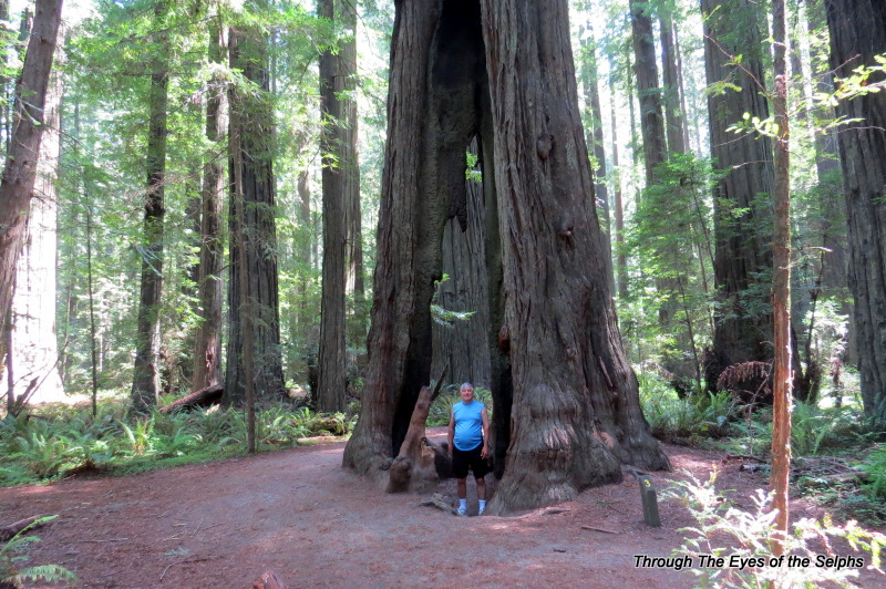
We spent our time in the Crescent City area hiking and geocaching in the beautiful park. IMG_20140525_160040 We both agreed that the redwood trees are a little more fabulous in Redcrest along the Avenue of the Giants since they seem to be larger in height and especially diameter.  But it is always amazing to be among the redwoods. IMG_0519


We were about 130 miles north of Redcrest and we noticed the forest seemed to be more damp with lots of moss covering the trails and trees. IMG_0525 The forests were certainly dense and it would not have surprised me to see a bear of mountain lion, but we saw neither.  We were told this area of California receives about one hundred inches of rain a year.  IMG_0521


One of our geocaches led us to a beautiful covered bridge built in the 1960’s and made of curved and laminated wood.  The process used is more often done in boat building. The roof, walls and floor were constructed as if it was a wooden boat. IMG_20140525_163922


After five months, it is hard to believe our time in California has come to an end, for now.  We are excited about reaching Oregon, but we love California and will return in the fall.


May 11, 2014 Redcrest, California (Avenue of the Redwood Giants)

We reluctantly left the beauty of tiny Westport-Union State Beach Park and our magnificent ocean views (one interesting fact the host of this beach park told us is that this area is known as the “Blood Triangle” because more shark attacks happen in this part of CA than anywhere else in the world except Australia) and headed up California Highway 1. I have talked in previous posts about what a difficult road this is to drive on, but the drive from here to Redcrest was the last twenty-five miles of CA 1 and the worst of the worst with 10 MPH horseshoe curves and narrow roads with no shoulders or guardrails and sheer drop-offs. We turned away from the coast and the road became more mountainous and curvy. We finally reached the end of CA 1 and began driving on U.S. Highway 101. We drove almost the entire CA 1 north from San Diego which had been on our bucket list. We are glad we did because the beauty of the California coastline is unlike anything anywhere else. I think I will see those curves and drop-offs in my sleep for awhile.

At the junction of CA 1 and 101 we saw a sign for a drive-thru tree and since it was only a quarter mile away we decided to check it out. For the admission of $5.00 you get to drive your car through a redwood tree.  IMG_0358 IMG_0362 IMG_0363These large and tall trees are the “Coastal Redwoods”. What a tourist trap and we didn’t even waste time in the gift shop. One of those glad we did it but once is enough experiences. There are two more such trees in this area but we will skip those. As we drove into Redcrest on 101 we saw many little gift shops and tourist attractions all taking advantage of the popularity of the beautiful redwoods in this area of California. We have traded the beauty of the Pacific coast for the magnificence of the redwoods. Away from the coast the temperature has gone up about fifteen to twenty degrees and everywhere we saw forests and redwoods. Beautiful!

We arrived in our campground in Redcrest on the Avenue of the Giants.  Redcrest is another small town with a population of 112 and relies heavily on tourism. We had good cell phone service in the main area of Redcrest but not in the campground.

Our first full day there we drove to Shelter Cove which was about a ninety minute drive from our campground.  It had been recommended by a campground neighbor and some tourist brochures.   I guess we have been spoiled by the beauty of the Pacific coastline because a long drive over very winding and curvy roads which climbed and then descended over 2,200 feet,  we arrived at Shelter Cove and were disappointed by the lack of views and beach there.  It certainly did not begin to compare to what we had seen in our previous travels up CA 1.  We did see a lighthouse there which at one time was further up the coast at Cape Mendocino. IMG_0364 The lighthouse was built in 1868 and lighthouse keepers had to take a small tender boat out to the lighthouse.  Due to the isolation this lighthouse was not a favorite of lighthouse keepers and it seems that men who did not follow orders or needed to be disciplined were sent to this lighthouse.  In 1948 the lighthouse was dismantled and moved into storage.  In 1999 it was moved and restored to Shelter Cove.

Before leaving Shelter Cove we did manage to find one geocache and saw some deer up close. IMG_0380 IMG_0371


The weather certainly warmed up with temperatures in the upper eighties and low nineties for several days.  This was quite a shock after the cool temperatures we experienced along the coast!  Avenue of the Giants is a thirty-mile 2-lane scenic driveIMG_0387 on what was once U.S. 101 surrounding by 51,222 acres of magnificent redwood groves. IMG_0427 IMG_0426 IMG_0423 IMG_0403 It is said to be the greatest display of Coastal Redwoods in the 500 mile redwood belt.

IMG_0408 IMG_0398 IMG_0389 IMG_0381  While in Redcrest we spent several days driving along the scenic Avenue of the Giants which is parallel to U.S. 101 and is surrounded by Humboldt Redwoods State Park.  The state park, established in 1921 to protect these magnificent trees,  is the third largest California state park and includes the Rockefeller Forest which is largest remaining old growth redwood forest in the world.  With 53,000 acres, it has many trails to hike and we also found several geocaches.


One trail we walked was the Gould Grove Nature Trail which has the third largest known redwood tree in circumference.  We also tried to find a geocache which included a rare albino redwood tree which is one of only a couple dozen known to exist.  We didn’t really know what an albino redwood was supposed to look like and couldn’t find anything that we thought resembled one.  We stopped by the Visitors Center and asked one of the rangers.  He gave us a paper with directions and it seems they rarely give the directions out because people have been known to touch the tree and pull off leaves so they stopped publicizing its existence.  We quickly found the tree and it was not what we expected.  The needles/leaves of the tree are white instead of green.

IMG_0429 IMG_0430


The same day we hiked to the Women’s Federation Grove which was founded in the 1930’s by members of the California Federation of Women’s Clubs.  Here there are picnic tables made from thirty to forty foot long redwood logs.  Today the area can be used for picnics since there are also grills and restrooms.  The focal point of the grove is a covered four-sided fireplace

IMG_0433designed by Julia Morgan, who also was the architect for Hearst Castle.

Along the top of each fireplace is an inspirational message.  Here are a couple favorites:

IMG_0435 IMG_0434On this day we were the only ones there and it was truly peaceful and tranquil with a river flowing alongside.


Later in the day we took another trail which led us first IMG_0445 IMG_0444to the “Tall Tree”.


Later we walked to the “Giant Tree”.

IMG_0452 IMG_0451 IMG_0456  This area was also used in the filming of the Stars War movie “Return of the Jedi”.  Since the seasonal bridge had not yet been placed for the summer, we had to cross a 20 foot wide stream with water up over our ankles.  When we got back to the car we had to wring water out of our socks!  But it was well worth it to see the Giant Tree and this beautiful area.


The next day we drove along the Avenue of the Giants to Founders Grove Nature Trail where we saw many amazing redwoods including the Founders Tree and
IMG_0467

IMG_0463


IMG_0480


IMG_0478


the Dyerville Giant which fell in 1991. They think it had been standing for as long as 1,600 years and was taller, larger and older than any tree around it.  It was 370 feet tall which is two feet taller than Niagara Falls, was seventeen feet in diameter and fifty-two feet in circumference, and weighed over one million pounds.  When it fell it registered on the seismograph and the locals said it sounded like a train wreck.  What an amazing week we had!

IMG_0483 IMG_0491

May 1, 2014 Bodega Bay, California

We left Santa Rosa and headed west and within a short time noticed the temperature dropping as we neared the coast. After a short drive we arrived at a nice county regional park in Bodega Bay where we would be staying for four days. Bodega Bay is a very small harbor village with beautiful views of the bay. We have found this area of Northern California has no Walmart or franchise restaurants that we are used to seeing. You will most definitely not find a McDonalds in this area of the state! While we were in Southern California we noticed that due to city/county ordinances, some Walmarts and grocery stores have done away with plastic bags and we have become accustomed to taking our own bags with us instead of paying ten cents for each paper bag. This is most definitely true for ALL of Northern California. We went in a McDonalds in San Francisco and there was a sign saying they charge ten cents for each paper bag they put your food in. Now that is taking “going green” a little to the extreme!!

We loved our campsite in Bodega Bay where we had a great view of the channel with boats passing by and plenty of waterfowl to observe. For the first time we noticed the beautiful wildflowers everywhere. IMG_20140501_150531 IMG_0160 IMG_0224


Our first day we drove up to the Bodega Bay Visitor Center and found out in 1963 the Hitchcock movie “The Birds” was filmed in Bodega Bay. We were told that last year they had a big 50th Anniversary celebration and Tippi Hedren, now 84 years old, visits Bodega Bay every year. The guide at the Visitor Center told us that around 8,000 people come here every year just because it is where the movie was filmed. We picked up a map with several locations to visit where they did filming for the movie. While in the area we rode past the schoolhouse shown in the movie, which is now a private home.  IMG_0214We also took a scenic drive along Bay Hill Road which is the same route that Tippi Hedren drove in the beginning of the movie and we were rewarded with some very picturesque scenery with the Pacific Ocean on one side and pastures with cattle grazing and calves running after their mothers. The road was narrow and very curvy and one we would have never taken without the map. We were very glad we did!  IMG_0222 IMG_0228 IMG_0218


We also rode up to tip of the peninsular Bodega Bay Head where they have magnificent views of the Pacific coastline. When we pulled up the parking lot was almost full and we noticed people with cameras standing and sitting on top of the cliff. IMG_20140501_144531Thinking something exciting was happening we hurried up there only to find that people spend hours here waiting for a whale or two to make an appearance. We are not quite that patient but we did enjoy the view!  IMG_20140501_144643 IMG_20140506_000729


The highlight of our visit to Bodega Bay was a visit to Point Reyes National Seashore ParkIMG_0171 that was only about 40 miles from Bodega Bay but took about an hour and a half due to the narrow and curvy roads both on California Highway 1 and inside the park. Our first stop was the Visitor Center where we read informational displays about the Coast Miwok Indians who were the first inhabitants of the area. We watched an interesting and informative movie on the history of the park that included English (Sir Francis Drake in 1579), Spanish and Mexican inhabitants in addition to the Indians. There have been generations of dairy farmers who have farmed the land and there are currently thirteen active ranches in the park. Throughout our drive around the park we saw cattle and crossed many cattle guards. President Kennedy signed legislation in 1962 making it a National Seashore Park and in 1966 Mrs. Lyndon Johnson formally dedicated the park to the American people.

The first thing we did after touring the Visitor Center was take a short walk on “The Earthquake Trail”. IMG_0165


They had blue stakes showing the location of the San Andreas Fault and at one point on the trail a twenty-foot movement had split a fence during the 1906 San Francisco earthquake.  IMG_0167 IMG_0166 IMG_0168


Next on our list was to drive to the Tule Elk Reserve. Before 1860 thousands of tule elk roamed the Point Reyes peninsula. Due to hunting they died out and in 1999 a herd was returned to the land. Today approximately 750 roam the land. We really wanted to see some elk and we had the mistaken impression all we had to do was drive to the edge of the reserve. Turns out it wasn’t nearly that easy. We came to the realization that if we wanted to see elk we would have to do some hiking so we found a popular trail and started out. The weather was sunny and fairly warm at the Visitor Center, but by the time we had driven ten miles to the reserve the weather was chilly, windy and foggy. We started down the trail and came upon a man who was carrying a huge elk antler on his back. He said they carry them out and grind them up and bring them back and spread them on the ground because the minerals are good for insects. Since we had seen a sign warning us not to collect antlers, we had to take his word for it.  We really wished we had thought to get his picture because it was really quite a sight to see!

After walking for a while along the narrow hilly trailIMG_0190 we saw some elk far in the distance. Definitely too far away to get a decent picture. IMG_0174We decided to hike a little further and came across two groups of hikers on their way back. Once group told us there were elk about 150 yards away. After walking what seemed to be much further than fifty yards we came to some more hikers who told us we would see them after about a five-minute walk. We continued on and walked much longer than five minutes. Either these hikers have a poor concept of time and distance or the elk were really on the move! When we reached the two-mile mark we decided to give up and head back.

Just at that point Bill looked to the left and saw a small herd lying down in the grass. They all turned their heads and looked right at him. The view was not perfect with the fog, but at least they were close enough to see them but Bill was able to enhance the pictures on his computer. IMG_0183 IMG_0187We left the trail and walked toward them to get a better look but stopped when one of them stood up in alarm. We didn’t want to scare them off.  We took some pictures and congratulated ourselves on finding them and not giving up. We headed back down the trail and Bill stopped suddenly and pointed ahead. There on the hillside happily grazing on grass and wildflowers was another group of twelve. They were close to the trail and did not seem alarmed at all by our presence, but we moved slowly and quietly so as not to alarm them.IMG_0199 IMG_0200 IMG_0194 IMG_0196 IMG_0201


During our elk hike we not only enjoyed seeing the elk but we saw beautiful fields of wildflowers and lovely views of the Pacific coast that would have been even more spectacular if it hadn’t been for the fog. IMG_0202


Even though it was foggy we decided to take a chance and drive up to the Point Reyes Lighthouse that is supposed to have breathtaking views of the area. Along the way we crossed more cattle guards and continued to see many cattle and calves nursing. One highlight for Bill was seeing the RCA Ranch and historic Radio Station KPH that was once at the forefront of communication technology. IMG_0211 IMG_20140506_000505 IMG_0205There was once here a wireless telegraph station where operators tapped out Morse code messages across the Pacific as far away as Hawaii. During World War II military and coast guard personnel used the property. The Radio Corporation of America (RCA) owned it and the park service acquired the property from RCA in 1999.


Today park personnel use the building as offices. IMG_0209


You may recognize the arched driveway of cypress trees leading to the house because it has been used in numerous car commercials. IMG_0210


We reached the lighthouse but just as we expected it was fogged in with heavy fog and we couldn’t see a thing. We drove the ninety minutes back to the campground marveling at all we had seen today!

We are finding that Northern California is simply enchanting!!

April 6, 2014 Big Sur, California

Our two days in San Simeon went by much too quickly and we set out for Pfeiffer Big Sur State Park.  It is hard to imagine a more beautiful drive than the one up the coast north from San Simeon to Big Sur. IMG_20140406_125547 IMG_20140406_125531 IMG_20140406_123834 P1040899 The only downside were the narrow, curvy and mountainous roads (sound familiar?) but the view was well worth the nails I chewed off. IMG_20140406_125017 IMG_20140408_015256 IMG_20140408_015451 P1040913 P1040924 I think it would have been much worse on my nerves if I hadn’t already been broken in by those treacherous Mexican roads.

Pfeiffer Big Sur State Park has been named one of the top 100 state parks in the country and it is easy is see why. P1050002 It is a beautiful park with towering redwoods, some are more than a thousand years old, P1040976 and many hiking trails of varying difficulty.  This was a dry camping experience for us but Bill was able to reserve a sunny spot among the redwoods for the solar panels and satellite dish.  Our neighbors were German and we encountered several German speaking people during our stay.

The first day we drove around the Big Sur area on the Pacific Coast HighwayP1040940 and stopped at several overlooks where we saw sea lions on rocks P1040937and dolphins swimming. P1040938 We went to Pfeiffer Beach where we had to drive two miles on a one way road to get to the beach area.  There were turnouts along the two miles where vehicles going in different directions could pass.  Pfeiffer Beach is one of the most picturesque beaches we have ever visited.  The waves have worn away the rocks in places creating interesting arches, and in places the sand has a purple color from the minerals in the nearby rocks.  P1040975 P1040971 P1040957 P1040954 P1040952 P1040951 P1040948

One day we took a “moderate” hike to the top of an eight hundred foot vista where we could look out to the Pacific Ocean.  The view was somewhat obscured by sea mist, but it was still lovely.  We then continued hiking down to a beautiful falls, very peaceful and tranquil.  P1040999 P1040996

The next day it felt like every muscle in my body hurt from the hike, but Bill felt no soreness or pain at all.  It took me a day to recover but the soreness went away surprisingly quickly.  The experience was worth every ache and pain!

Big Sur is definitely a place we would love to come back to again.  There were many trails left undiscovered.  As we drove away from Big Sur we could see fog and sea mist hovering over the mountains and we encountered another amazing bridge that opened in 1932.  P1050003 P1050005

January 20, 2014 San Diego, California

We arrived at our next destination at a Thousand Trails RV park about 20 miles east of San Diego. 01-IMG_20140122_133740 They did not have a full hookup site available so we were directed to the north side of the campground where we had our choice of several electric and water sites.  They have an unusual way of providing full hookup sites, and we discovered that a reservation did not mean you have full hookup upon arriving.  If all the full hook up sites are taken, your name goes on a list and the next morning at 8:30 you go back to the ranger station.  They write on a board all the site numbers of people who are checking out that day.  When your name is called, you get to choose which site you want.  We knew we were #9 on the list for the day, and since there were only 7 sites available and  many people waiting, we didn’t hold out much hope of getting a site that day.  To our surprise, our name was the third name called and we chose a site.  We went back and got our RV and moved to our new site.  This whole process is called “Crossing Over”.

We very much liked our new site.  It was a corner lot so we only had neighbors on one side  and across the street.  There was an access road near us which was used by the border patrol and it was interesting to see them come and go and we sometimes heard helicopters at a distance flying overhead, but nothing at all annoying.  It was actually very quiet during the day and at night, and the only sound we heard was the occasional coyotes howling at night.  One day we saw a couple coyotes roaming several feet from our campsite, but they hurried on in their quest for prey. 02-IMG_20140124_183313 We also found some interesting geocaches around the campground.  The only problem we had with this campground is there is no cell phone or internet service with our Verizon phones.  They provided free 30 minutes of internet per computer each day, with more available for purchase, but we found it to be very slow, and it still did not solve our cell phone problem.  Several times we had to make a call and had to drive several miles toward the nearest town to make a call.  We think this problem can be solved with a cell phone booster which we hope to purchase before possibly returning to this campground in the future.

One day we rode over to Coronado Island which is a resort city across the San Diego Bay from downtown San Diego.  It really isn’t an island, but is instead a peninsula, and to access the city we had to cross a 2 mile bridge.  Oh, how I have missed the water of Florida, and San Diego has given me my water fix. 04-P103081903-P1030817 Hotel de Coronado is located there and is considered one of the world’s top resorts.  The Marilyn Monroe film, “Some Like It Hot” was filmed at this hotel. 14-P1030844 16-P1030841 Frank Baum, author of “The Wizard of Oz”, could see the hotel from the front porch of his home, and some say The Emerald City in the movie was inspired by the hotel.  Baum also designed the crown chandeliers in the hotel dining room.  Because of this connection with Oz, Coronado is often called “The Emerald City”.

A visit to Coronado wasn’t complete without putting our feet into the cold Pacific Ocean.  They had beach advisories that day because of windy conditions, but it didn’t feel that windy to us. 05-P1030820 07-P1030826 08-P1030829 09-P1030830 06-P1030822 10-IMG_20140127_140044 11-IMG_20140127_140203 12-IMG_20140127_140809 15-P1030840 13-IMG_20140127_141137

We finished the day with a visit to Imperial Beach where we grabbed the most south westerly located geocache in the continental United States.  We could see Mexico in the distance and several helicopters were flying low overhead to patrol this section of the US/MX border. 17-P1030847 18-P1030850 We assume they were border patrol monitoring the border.  We have seen a lot of border patrol over the past couple months and it is amazing when you think about the amount of land they have to monitor.

Next stop:  San Diego Zoo!

January 10, 2014 Palm Desert, California

We are truly in awe of the mountains and canyons we are seeing in the desert of California.  We left Anza-Borrego Desert State Park and arrived in Palm Desert where we are staying at a Thousand Trails RV Resort.  Usually the Thousand Trails parks are located in fairly remote areas, however this one is located right in Palm Desert.  We prefer parks that are further away from traffic and road noise, however this park was not too noisy and sometimes it is convenient to be near stores and restaurants.

The highlight of our three nights in Palm Desert was our visit to Joshua Tree National Park on Saturday. 1-P1030629 Located over an hour from Palm Desert, the park is named for the trees that grow there called Joshua trees.  Legend has it that the trees were names in the mid 19th century by Mormon pioneers who named the tree after the prophet Joshua because of the trees outstretched limbs.

Roosevelt designated the park a National Monument in 1936 and it was re-designated a national park in 1994.  One interesting thing about the park is that two deserts come together to make Joshua Tree National Park.  The Colorado Desert with an abundance of creosote bush makes up the eastern half of the park.  06-P103064605-P1030644 04-P1030643 03-P1030636 02-P1030635

The higher, cooler and wetter Mojave Desert with Joshua trees, make up the western half of the park. 13-P1030671 15-P1030679 12-P1030669 14-P1030672 11-P1030668 We were able to drive through both sections of the park and enjoyed the different landscapes.

We hiked a short trail to Arch Rock where campers had hiked among the rock formations. 10-P1030665 09-P1030661 It was not unusual to see campers boondocking throughout the desert in Arizona and California. 07-P1030654 08-P1030659The rock formations in the park were amazing and we spent some time watching rock climbers scaling the sides of these mammoth rocks.  The park is known for being one of America’s best climbing sites. 20-P1030696 19-P1030695 18-P1030691 21-P1030699 22-P1030700

We drove to the top of Keys View with an altitude of 5,185 feet. 17-P1030683 On a clear day you can see to Mexico as well as the Salton Sea, the San Andreas Fault, the San Jacinto Peak behind Palm Springs, as well as the Santa Rosa and San Gorgonia Mountain.  16-P1030681The day we visited had some haze from Los Angeles smog, but we still had a breathtaking view.  Sadly one of the rangers told us, and we saw a sign at Keys View, that due to poor air quality, the park is one of the unhealthiest places to hike during certain times of the year.  We have noticed this smog for several weeks in our travels.

Palm Desert is a beautiful place with ideal winter weather.  Another place to add to the return someday list!

January 7, 2014 Borrego Springs, California

We fell in love with beautiful Anza-Borrego Desert State Park in Borrego Springs the minute we arrived. 4-P1030582 We had a wonderful view of the mountains right outside our front window, and our campsite was arranged so we could leave our front shades up and not worry about our privacy.  The first hour we were there we saw a big jack rabbit. We enjoyed the view from the time we woke up each morning until darkness settled in each night.  1-IMG_20140108_104103 2-IMG_20140108_104137Sadly, we were only there 3 nights.  Anza-Borrego Desert State Park is the largest state park in California with 500 miles of dirt roads, 12 wilderness areas, and many miles of hiking trails.  The park is named after the Spanish explorer Juan Bautista de Anza and the Spanish word “borrego” which means bighorn sheep.  As we drove from El Centro to Borrego Springs, we noticed many campers who had set up camp in the desert.  Some set up solitary sites while others seemed to form little wagon trains in the desert. 1-P1030572 We also noticed that we continued to be below sea level for part of the drive west.  5-IMG_20140111_202425

The first day we made the 45 minute drive that took us over a ridge of 4,200 feet to Warner Springs to see Bill’s cousin Sandra and her husband Ed. 7-P1030601 The view was amazing but the road was very winding with steep drop offs. 5-P1030597 4-P1030590 We enjoyed spending time with Sandra and Ed in their lovely home.

On Thursday we spent the day exploring Borrego Springs by doing some hiking and geocaching.   After stopping by the Visitors Center which included an interesting movie about desert plant and animal life, we took a hike which turned out to be more challenging than we expected as it took us over a fairly rocky trail that was longer in length than was shown on the park map. 1-P1030607 2-P1030613 We always enjoy our desert hikes with the beautiful plant life, however we did not encounter the birds and wildlife we had hoped to see.  We were amazed to see his and her bathrooms in the middle of the desert!  3-P1030614

After the hike we spent the rest of the day geocaching in Borrego Springs where there are more than 130 free standing steel metal sculptures created by Ricardo Breceda of Perris, California spread over a 3 mile area of desert landscape.  Luckily for us, several of these sculptures had geocaches hidden in them, and we were able to enjoy both the sculptures and get in some geocaching!  The size and detail of the sculptures were truly amazing!  6-P1030619 4-P1030615 9-P1030628 8-P1030622 7-P1030621 5-P1030618

Our list of places we want to return to someday is growing, and Anza-Borrego Desert State Park is definitely on that list!


January 3, 2014 El Centro, California

California here we come!  We loved Yuma, but we had been eagerly anticipating our arrival in California, so it was with much excitement we crossed the border from Arizona into California. We noticed the landscape went from flat, desert dirt with small shrubs and cacti, to a more sandy appearance with huge sand dunes with little or no plant growth.  We saw some dune buggies in the distance climbing the high sand dunes.

Sand dunes with dune buggies in the distance. taken from car window

Sand dunes with dune buggies in the distance. taken from car window

4-IMG_20140103_115108

.

3-IMG_20140103_115100

Campers boondocking in the desert

5-IMG_20140104_171342

Dune buggy paths

1-IMG_20140106_222656
one of many canals in the desert

Our first stop was the small farming community of El Centro.  In this area we noticed more evidence of farming, especially lettuce and other greens.  We also noticed huge covered bales of hay along the side of the road in several places.  There is not much to do in El Centro and the RV resort where we are staying is geared more to golf and not much else, so we used our time there doing paperwork and trip planning for January.  The resort was very quiet and we enjoyed the relaxing time there.

6-IMG_20140104_171005

.

The highlight of our time in El Centro was when we drove 60 miles north to see the Salton Sea. At 45 miles and 25 miles wide it is one of the world’s largest inland seas and the largest lake in California.  It is also 227 feet below sea level which makes it one of the lowest spots on earth.  With its marine, freshwater, desert, wetland, and agricultural habitats, it has the second highest number of different species in the country with over 400 species.  More importantly is the dependence of a large bird population on the lake because just below the surface is an abundance of fish.  Scientists called the Salton Sea “California’s Crown Jewel of avian biodiversity” and is thought to be one of the most productive fisheries in the world.  1-2014-01-05

The Salton Sea is currently 25% saltier than the ocean and getting saltier every day because the lake has no outlets.  Water flows into the lake from the Whitewater, Alamo and New rivers which brings salt from the Colorado River.  The only way water can leave the Salton Sea is by evaporation.  There is estimated to be 500 million tons of salt in the Salton Sea.  This salinity is seen as a time bomb to the future survival of fish and birds. There are government projects underway to reduce the salt.

The Salton Sea was the setting for the 2002 movie, “The Salton Sea”.  We enjoyed our visit there very much.  We had read before going that the smell there can be very bad, especially during windy days as the wind dredges up all the sediment and dead materials from the bottom of the sea.  The wind was calm during our visit and we detected no unpleasant odors.  They have a very nice visitors center at the park 04-IMG_20140105_140215 02-IMG_20140105_133459 06-IMG_20140105_131558 03-IMG_20140106_222511 where we enjoyed a nice picnic lunch 05-IMG_20140105_131546

Rock with petroglyphs

Rock with petroglyphs


07-IMG_20140105_133559

and saw a short movie about the history of the area.  The park has full hookup sites but for a third of the cost you can boondock at one of their wilderness areas.  While driving around we stopped and chatted with a couple from Oregon who had come down to the Salton Sea for 2 months and were hosts at one of the wilderness areas on the sea.  With the closest grocery store being 30 miles away, and the only place to get water and dump our fluids being 7 miles each way, we decided this was not a location we would come back to camp.

After leaving the visitors center we drove to nearby Mecca where we did some desert canyon geocaching.  We completed finding 200 geocaches in 2013 and now are starting our goal of another 100 in 2014. We had a great time and saw some truly beautiful areas.  This is a good time to do some desert geocaching because we feel fairly confident that we will not encounter any crawling creatures, though we are always vigilante about where we place our feet and hands no matter where we are geocaching. 12-IMG_20140105_144743 09-IMG_20140105_143458 13-IMG_20140105_144751 14-IMG_20140105_144839 10-IMG_20140105_143623 11-IMG_20140105_144437 15-IMG_20140105_144953 16-IMG_20140105_153610

1-20140105_161251One geocache was hidden inside a plastic duck hidden in this canyon


November 8, 2013 Houston, Texas

On the way to Houston we stayed one night in the Sam Houston National Forest at Cagle Campground.  What a nice campground!  We had a large site with a concrete pad and full hookup.  This is not what is usually available in a national forest campground!

We arrived in Houston 01-IMG_20131108_195417for a 5 night stay at a private campground about 13 miles outside of the city of Houston.  It was a nice site with a concrete pad and full hookup, but without the space, trees and privacy we found at the national forest campground.  It also had some traffic noise from the interstate close by.  It seemed more like a concrete jungle after the state parks we have grown accustomed to camping in.  After dealing with the mud and dirt from all the rain in Dallas earlier in the week, the concrete pad was nice, but we would have really liked some trees and grass!

On Sunday we drove into Houston to visit our friend Priscilla and her husband Roy.  We met Priscilla when we lived in Northern Virginia and she is now living in Houston.  It was SO good to spend time with them!  We had a great meal at a barbecue restaurant and after eating they gave us a nice tour of Houston and Rice University campus.  1-P1030167


02-P1030171Monday we drove 45 minutes to Brazos Bend State Park to do some geocaching and orienteering.  It is hard to find permanent orienteering courses and we were pleasantly surprised to see they had one in this park.  While driving in we noticed signs saying the area had alligators and venomous snakes.  We drove to one lake in the park and walked around and to our disappointment we didn’t see any alligators.  We pretty much decided we wouldn’t see any that day because the lakes were way down from the ongoing drought in Texas.  We decided to find two geocaches near an observatory in the park.  As we parked our car we encountered two elderly ladies who calmly and nonchalantly told us they had seen an alligator on the trail near a small bridge over the water.  We thanked them for telling us and thought they surely had seen an alligator in the distance sunning on a far bank.  To our astonishment as we walked down the path we came upon a huge alligator estimated to be 7 or 8 feet long five feet away from us.   04-P1030175We figured if those two ladies could get by him alive, so could we, so Bill told me to give him the camera in case we had to start running.  He took my hand and led the way as we slowly and carefully walked past the alligator.  If truth be told, he had to slightly pull me past the alligator because my feet were not so eager to walk past the creature.  We found our geocaches and then headed back down the trail thinking we would once again inch our way past Ally Alligator.  To our amazement, in the short time we were gone, the alligator stretched his body across the trail, blocking our way.  06-P1030182Since it didn’t look like he was in any hurry to get on his way, we had to find another trail back to the car.  Bill and I both agreed this was the closest we had ever been to an alligator of that size….a once in a lifetime experience when you least expect it!  Never thought we would leave Florida to have a close and personal encounter with an alligator in Texas!  On the way to the car we saw another huge alligator on a small island in the water and a little baby alligator sunning on a rock in the water.  We also saw many turtles, a bunny, and a lot of birds.  05-P1030179 09-P1030185 07-P1030183 10-P1030186 08-P1030184


While orienteering later in the day we saw another 7 foot alligator on a bank across the lake, but he dove into the water before we could get a picture so we had to be satisfied with one of him in the water as he swam away.  11-P1030188We came home tired and happy from our fun and exciting day in the park!

October 3, 2013 Carlyle Lake, Illinois

Our plans to camp at an Army Corps of Engineers campground at Carlyle Lake were derailed with the shutdown of the federal government.  Instead we went to an Illinois state park, Eldon Hazlett State Recreation Area at Carlyle Lake.  This campground, illini, is one of the largest in Illinois, and is located on the largest manmade lake in Illinois.  The campground was almost deserted this time of year in the middle of the week.  We had a choice of a site, which was an electric only site.

We hiked on the Cherokee Trail and really enjoyed the nice trails, which included several bridges and steps.  The views were beautiful and they had benches at overlooks along the way.  At times we felt that squirrels were throwing walnuts and acorns at us from the trees overhead, and we saw many empty walnut shells along the paths.

1-P1020874 2-P1020875 3-P1020880 4-P1020881