Monthly Archives: May 2020

Brigham City, UT May 26, 2020

Leaving Provo we drove 100 miles north to Brigham City, Utah pop 19,000. Brigham City is much smaller than Provo or Salt Lake City and we enjoyed the small town feeling of the city. Brigham City was named in 1877 for Brigham Young who delivered his last public address there in 1877.  IMG_20200531_121100

Bill and I felt comfortable enough there to both get haircuts which we really needed. 

We were there for a week and enjoyed touring the area. One day we drove 32 miles to Corinne where we visited the Golden Spike National Historic Site.  IMG_20200527_124309IMG_20200527_125511It was here at Promontory Summit that the Union Pacific (UP) and Central Pacific (CP) rails converged to form the nation’s first transcontinental railroad on May 10, 1869. A golden spike and three other precious metal spikes were placed to commemorate the occasion. Those spikes were then removed and replaced by a regular wooden tie secured to the rail with iron spikes to officially complete the railroad.  IMG_20200527_131556~2

It had taken six million spikes and six years of hard work to complete the railroad. At times distracted by the Civil War, facing rough terrain and raids by Sioux and Cheyenne, they managed to get the job completed. Eight flatcars of material was needed for each mile of track and every rail, spike and locomotive had to be shipped 15,000 miles around Cape Horn. What a logistical nightmare! With the help of unemployed Irish, German and Italian immigrants, Civil War veterans, ex slaves and Native Americans, a total of 8,000 to 10,000 workers laid two to five miles of track a day on flat land. 

The Pacific Railroad Act of 1862 mandated that only American made iron could be used. The demand for iron for building the railroad helped boost the domestic economy. By the 1870’s the iron rail was replaced with sturdy steel rail which had become more widely available after the Civil War. 

Congress authorized Central Pacific to build a railroad eastward from Sacramento and at the same time chartered the Union Pacific in New York to go westward. Due to a lack of precise instructions from Congress as to where the rails should meet and financial rewards for building the railroad, the two railroads prepared rail-beds parallel to each other for 250 miles.  IMG_20200527_130738IMG_20200527_130845

Each railroad received loan subsidies of $16,000 to $48,000 per mile depending on the difficulty of the terrain. Once it was determined the rail-beds were parallel, the railroads were ordered to unite the track. No railroad tracks were ever laid on the parallel beds. Promontory Summit was then chosen as the point to join the tracks. IMG_20200527_140209IMG_20200527_140231big trestle~2

Central Pacific (CP) laid 690 miles of track and Union Pacific (UP) 1,086 miles of track across desert, rivers and mountains to unite the east and west coast with 1,776 miles of rail. This brought big changes to the country. People were now able to travel cross country, there were new opportunities for commerce and it opened up settlement in California, Colorado, Nebraska, Nevada, Wyoming and Utah. What had once been a six month journey was now just a week. The prairie schooner was replaced by a railroad coach with all its comforts.  

Legislation also called for a telegraph line to be strung along the transcontinental route to bring in a new era of instant communication from coast to coast. When word went out by telegraph in May, 1869 that the railroad and telegraph were completed, Americans celebrated in city after city with church bells ringing, cannons firing, parades, prayers, and singing of the “Star-Spangled Banner”. IMG_20200527_131958

Due to the pandemic we were disappointed that the Visitors Center and theater was closed. The working replicas of the 1869 steam locomotives named “119” (Union Pacific”and “Jupiter” (Central Pacific) were in storage and not in view. Last year on the 150th anniversary they were placed nose to nose.

We were able to drive the two mile East Auto tour which followed old railroad grades and showed the parallel grading completed by the railroad companies.  IMG_20200527_135216IMG_20200527_135001~2IMG_20200527_135011~2

We saw the Chinese Arch formed by waves crashing against the ancient shore 300 million years ago which eroded the rock. It is believed it was given the name Chinese Arch in recognition of the presence and contribution made by the Chinese who worked on the railroad. IMG_20200527_135415~2

On the way home we stopped by the Northrop Grumman Innovation Systems Rocket Garden. The garden displays rockets and missiles built from the 1950’s to the 2000’s. IMG_20200527_144045~2

One of the rockets is a shuttle booster that took the spaceship with its astronauts to a speed of 17,4000 miles per second. There is also a Minuteman intercontinental ballistic missile, a Maverick air to ground missile designed to be launched from Black Hawk helicopters and an Atlas rocket motor just to name a few of the 39 exhibits.  IMG_20200527_143411IMG_20200527_142248

Patriot missiles are a long-range, all-altitude, all-weather air defence system to counter tactical ballistic missiles, cruise missiles and advanced aircraft.  IMG_20200527_143503~2

On another day we drove over an hour on the Logan Canyon National Scenic Byway to beautiful Bear Lake. Often called “The Caribbean of the Rockies” because of its intense turquoise blue water, the color of the lake comes from limestone that has calcium in it. IMG_20200531_141230

The calcium, like millions of microscopic mirrors, reflects light from the sky. Bear Lake changes color depending on the weather, wind and time of day. It is believed Bear Lake formed 455,000 years ago. From 1350-1850, thousands of years Native Americans such as the Shoshoni, Ute and Bannock tribes lived in Bear Valley. Bear Lake was discovered in 1812 by trappers returning home from Astori, Oregon. The valley became an important fur trade center. Most of the settlers came from Britain. IMG_20200531_141610IMG_20200531_143951

We enjoyed driving around part of Bear Lake on the Oregon Trail Bear Lake Scenic Byway. Bear Lake is so big it is located in both Utah and Idaho. IMG_20200531_160505IMG_20200531_150836IMG_20200531_153547IMG_20200531_153617

After six weeks in beautiful Utah it is time to move on. IMG_20200531_172629

Next up: Twin Falls, Idaho

Provo, Utah May 20, 2020

We left Panguitch a day late due to high winds with gusts of 55+ mph forecast for the area. We had to drive back over the pass towards Salt Lake City and didn’t want to do that with extreme winds. 

Our next stop was in Provo, pop 119,000 about 45 miles south of Salt Lake City. We were once again treated to beautiful views of snow capped mountains. The first thing we noticed at the campground was all the green trees and grass. After being in southwest Arizona for so long, we had forgotten the sights and smells of green trees and freshly cut grass. IMG_20200520_155442IMG_20200520_155603IMG_20200520_155630

We also noticed tiny white seeds falling from the cottonwood trees. If it had been winter we would have thought it was snow flurries. After an especially windy day the ground was covered in cotton seeds that looked like snow. We learned that this shedding of the cottonwood seeds occurs in late spring and early fall. In the past Bill and I have both had allergies from the cottonwood trees in Arizona. Thankfully this time they didn’t bother us.  IMG_20200526_102720IMG_20200526_102725IMG_20200526_102749

During our time in Provo the weather was very chilly with nighttime lows in the 30’s.

Utah continued to be under a yellow advisory and we were still careful and wore masks when going to the grocery store. Other than grocery shopping we stayed away from stores and public areas. 

When we planned our summer travels last fall we planned to visit the Utah state capitol building in nearby Salt Lake City. When we were in Salt Lake City five years ago we drove by the outside of the capitol but didn’t take the time to tour the inside. Unfortunately, this time the building was closed to the public due to the pandemic. IMG_20200525_132239-EFFECTS

We did manage to visit Bridal Veil Falls, a short drive from the campground. It was a beautiful drive with the snow capped mountains around us. The falls is a beautiful natural 607 foot tall double waterfall in Provo Canyon along the Provo River. In 1961, a tram was built, supposedly one of the steepest in the world which took visitors to the top of the falls. The tram was destroyed in an avalanche in 1996 and was never repaired. Such a shame as that would have really been fun to ride! IMG_20200523_142650IMG_20200523_142641

One afternoon we drove around the campus of Brigham Young University in Provo. Opened in 1877 and with a 634 acre campus, it is one of the largest church related private universities in the country.  IMG_20200523_144655

We saw the 112 foot Centennial Carillon Tower where 52 bells ring at intervals during the day. The university was closed and the campus empty due to the pandemic.  IMG_20200523_150848-EFFECTS

Next door to our campground was an interesting area with antique gas station signs. IMG_20200523_135622IMG_20200523_135812IMG_20200523_135838IMG_20200523_135933IMG_20200523_140056_MP

We even saw Elvis and Marilyn! IMG_20200523_135858

Next up: Brigham City, our last stop in Utah


Bryce Canyon N.P. May 8, 2020

We left Cedar City, Utah and traveled north on Interstate 15, still during the isolation rules of COVID-19 Pandemic. Since it was a short distance and we would be traveling over a steep pass, we decided I would follow behind in the car rather than towing. Look! There is Bill ahead of me with snow capped mountains in the distance. IMG_20200506_125325

We arrived at our campground near the tiny town of Panguitch, Utah. Its claim to fame is Butch Cassidy was born just down the road. Butch Cassidy and his gang once had their photograph taken in Panguitch. We last camped here in late August, 2015.  It is a no frills and very reasonably priced campground. We settled in for a two week stay. The first few days the temperatures were perfect during the day but too cold at night. One night the temperature got down to 21 degrees! We left the faucet dripping during the night and fortunately had no problems. 

Since our last visit here in 2015 we had been anxious to visit Bryce Canyon NP again. Of the five national parks in Utah, this was our favorite. While many Utah national parks remained closed, because of the virus, we were very fortunate to have Bryce reopen with some restrictions. The Visitors Center, most restrooms and most trails were closed. 

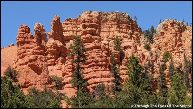
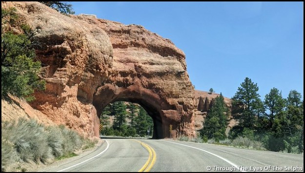
On Friday we made the 25 mile drive from our campground to Bryce Canyon. To get to Bryce Canyon we drove on Highway 12, The All American Road. We passed through Red Canyon, part of Dixie National Forest with its beautiful red sandstone and limestone formations and through two tunnels. IMG_20200508_140026IMG_20200508_140439IMG_20200515_162353-EFFECTSIMG_20200508_142051

The fee booth at the park entrance was not manned but they had maps and park information available. 

Our goal today was to do the eighteen mile scenic drive and stop at the fourteen overlooks. Bryce Canyon isn’t really a canyon but a plateau with a series of horseshoe shaped amphitheaters carved in the edges of the eroding plateau.  Bryce Canyon was settled by Mormon pioneers in the 1850’s and is named for Ebenezer Bryce, a Mormon settler who homesteaded the area in 1874. It became a national park in 1928.

Some viewpoints could be seen from the road while others required short walks, usually on paved walkways. The views were all amazing. Our favorite was the many hoodoos, which are towering rock formations sculptured over time by ice freezing and thawing, some as much as ten stories tall.  There are approximately 200 days of freezing/thawing at Bryce Canyon each year.  IMG_20200508_152548

It was fun to let our imaginations run wild and imagine faces or figures in the formations.  The Paiutes, original inhabitants of the area, believed that the rock figures were people turned to stone by angry gods.  If you look closely you can also see fairy tale castle formations. Iron oxide gives red, yellow and brown tints to the limestone. IMG_20200508_145640

One overlook was at 9,100 feet and it was very chilly. The number of tourists was low and it was nice to be able to drive through the park with very little traffic and no crowds at the overlooks. IMG_20200508_145744IMG_20200508_150116IMG_20200508_150148IMG_20200508_150238IMG_20200508_150314IMG_20200508_150443IMG_20200508_152218IMG_20200508_153110IMG_20200508_153217IMG_20200508_153235IMG_20200508_153320IMG_20200508_154015IMG_20200508_154043IMG_20200508_154144IMG_20200508_160624IMG_20200508_161030IMG_20200508_162234

The following Friday we went back to the park. This time there was a person at the fee booth with the window closed, not taking fees but handing out information through a slot. Unlike the previous Friday the Visitors Center was open with limited capacity but the theater was closed. We wanted to see the informative movie about the park we remembered from 2015, but since the theater was closed we didn’t stop. IMG_20200515_141150IMG_20200515_141200IMG_20200515_141606IMG_20200515_141611IMG_20200515_144258IMG_20200515_144434

There was more traffic than the previous Friday. We passed by the prairie dog natural habitat area with signs warning of wildlife crossings. A prairie dog ran out in front of us and we stopped. He ran to the center of the two lane road, got confused and stopped. He then ran toward our car. We were unable to move until he moved to one side or the other. An impatient driver behind us honked his horn, and when we didn’t move, he zoomed past us on our right hand side. Not knowing where the prairie dog was we held our breath that he didn’t get hit. Usually when somebody does something irresponsible like this there are no police around to see it. But fortunately there was a Ranger headed in the opposite direction and saw what happened. He made a u-turn, turned on his lights and pulled the driver over. The Ranger looked pretty annoyed when he stepped out of his car. I never can understand why people come to places like national parks and are so impatient and in such a hurry. As for the prairie dog, he ran to the side of the road and lived happily ever after! IMG_20200508_163834IMG_20200508_164532

Our main focus today was to walk the rim trail along the top of the canyon. When we were here five years ago we made the arduous hike on the Navajo Trail down into the canyon. On this day the Navajo Trail was closed indefinitely due to severe damage from winter weather. We talked with a Ranger who said they were going to have to call in a geologist for advice on how best to repair the popular trail. IMG_20200515_151127IMG_20200515_151140IMG_20200515_154702IMG_20200515_154944IMG_20200515_155054IMG_20200515_153837

Our last days in Panguitch were very windy with gusts up to 45+ mph. We delayed leaving by one day because of the windy conditions since we would have to go back over the pass on the way to our next destination. Most of Utah is now open for business but physical distance and masks are required.

Next up: Provo, Utah

Sheltering in Place Spring 2020

Hope you are all safe and well while sheltering in place. We spent most of March and all of April doing the same thing! 

We left Yuma, AZ on March 15th and spent a week in Quartzsite, AZ. We were then supposed to spend two weeks in Palm Springs, CA. But as we watched the events unfold in mid March it became very clear we needed a safer area to shelter in place. We were following the daily statistics on the progression of the virus around the country and knew Palm Springs with its high density population was not the safest place to stay. We canceled our reservation and chose Needles, CA, a very small town right across the border of Arizona and California. From our campsite we could look across the Colorado River and see Arizona. The Walmart where we ordered groceries online for pickup was located in Arizona, ten miles away. 

The campground did a nice job of protecting people by spacing everyone out so we didn’t have anyone near on either side of us. We were there a month, basically doing what everyone else was doing, watching the news, hoping for the end of the virus and for things to get back to normal. 

By mid April restrictions were still not being lifted and while we would have been content to stay in Needles longer, but we faced a new problem. A Mohave heat wave was forecast to hit the area with daily highs well over a hundred degrees. It is not easy to stay cool in an RV with those temperatures. It was time to move on. We decided to cancel our reservation in Las Vegas because the city has a large population and it was due the same hot temperatures.

We found a campground on Indian tribal land in Cedar City, Utah. We wondered if they were accepting new people there since the country was still under quarantine. We held our breath and called. Thankfully they gave us a reservation! Bill continue to binge watch the TV show Nash Bridges and completed it. IMG_20200430_133716

On April 22nd we left Needles and headed to Cedar City. The 280 mile drive was interesting as we left California, passed through Nevada, then a small corner of Arizona and finally into Utah. The traffic was light except for a little congestion around Las Vegas. As we entered Nevada there were traffic signs reminding people to shelter in place. IMG_20200422_103629IMG_20200422_103717_1IMG_20200422_140444

It was a lovely drive with snow capped mountains in the distance and the beautiful red rocks of Utah. IMG_20200422_142433IMG_20200422_142554IMG_20200422_142703IMG_20200422_142754IMG_20200422_142825IMG_20200422_143522

Utah is such a beautiful state! Utah has a website that all visitors must submit their information on upon entering. IMG_20200422_143600IMG_20200423_142954

We stayed at the Cedar City campground for two weeks. We had a no contact check-in process and once again they spread everyone out so there was distance between us. We had beautiful views of snow capped mountains from our campsite. IMG_20200424_142143IMG_20200424_142526

With pleasant temperatures in the 70’s, we felt very fortunate to be there. We had avoided the 110 degrees temperatures in Needles CA. While there we continued to isolate ourselves and ordered our groceries online for pickup from Walmart.  

We heard on the local news out of Salt Lake City that one day four Air Force F-35 planes would be flying over Salt Lake City to honor health care workers. The flight path would take them over Cedar City and then down to St George before flying back toward Salt Lake City. We waited outside during the time they were scheduled to fly over us. We were slightly disappointed because they flew so high they were barely visible but we could still hear them approaching. But still nice to see and hear! IMG_20200430_135751

Next up: Continuing our summer plans to Bryce Canyon, Utah