Monthly Archives: June 2018

Ketchikan, AK June 29, 2018

Before we move on to the next port, we would like to begin this blog with some additional animated photos from our whale watching expedition in Juneau.

The last port stop on our cruise was in the town of Ketchikan, pop 8,050.  Ketchikan is the fourth largest city in Alaska. It was established in 1887 and is Alaska’s southernmost city at the base of the Tongass National Forest.  IMG_20180629_160950

Situated on Revillagigedo Island, it is separated from mainland Alaska by the Behm Canal. The town was formed when a salmon cannery was built at the mouth of the Ketchikan Creek and claims to be the salmon capital of the world.  IMG_20180629_153824

It has an average annual rainfall of 156 to 162 inches which makes it the wettest community in North America. We would agree since our day there was chilly and overcast with occasional drizzle. 20180629_10000920180629_160934

Ketchikan’s economy relies on fishing, canning, mining, logging, cold-storage operations and of course tourism.  The town has a large native culture with the largest concentration of Tlingit, Haida and Tsimshian people in Alaska.  This is obvious in the many totem poles in the area. It is believed Ketchikan has the largest number of totem poles in the world. IMG_20180629_142434

We had a nice view of this picturesque town from our balcony.  We were fascinated by the extremely hilly, steep road in the distance.  Very hard to capture on camera just how steep it was. 20180629_09561120180629_09562220180629_095827

Instead of taking another excursion, we decided to spend a relaxing day exploring the town.  We took a free shuttle bus around the town and then got off a mile from the ship in the touristy area.  Here we walked around the Creek Street Historic District, a notorious rowdy part of Ketchikan’s past. This area, with houses built on stilts, was a red-light area of town from 1902 to 1954.  Not really a street, it is actually a zigzagging boardwalk of pilings with at least 30 former bawdy houses. During prohibition, bootleggers would smuggle in Canadian whiskey for the bawdy houses and saloons.  The bootleggers would wait until high tide and row their rowboats upstream to deliver their goods under cover of night. Most of the houses had hidden trap doors underneath to receive the goods. There was a “Married Man’s Trail” which was a staircase and wooden boardwalk where men could visit the houses without being seen going in the front door. IMG_20180629_150034

Today the area has art galleries, gift shops and a museum.  Of particular interest was a museum, Dolly’s House, where infamous Madam Dolly Copeland Arthur lived from 1919 to 1970. The “street” was built over water because it was too difficult to blast away the rocky hillside. For this reason much of Ketchikan was built over water. Creek Street is one of the best places to see salmon spawning and swimming upstream. IMG_20180629_150008IMG_20180629_150213

On our walk back to the ship we found several geocaches and did a little shopping. We stopped at The Rock, a Monument to Ketchikan which is called “The First City”.  It is not called that because it was the first city established in Alaska but because it is the first city you reach when coming from the lower 48 states north along the Inside Passage.  The seven figures represent the city’s history which includes a fisherman, a miner, a logger, a bush pilot, a frontierswoman and a Native drummer. Chief Johnson, the seventh figure stands atop the rock, who as a Tlingit, represents the fact that his people were the first to make their home in southeast Alaska. IMG_20180629_161011IMG_20180629_16110120180629_162004

The final day of our cruise was spent at sea as we headed towards our destination of Vancouver, British Columbia.  It was a day spent relaxing, eating of course, visiting with Peter and Beth and packing since we had to have our luggage outside our door by midnight.  IMG_20180630_160435IMG_20180630_154643

Today, June 30th was also the fifth anniversary of our living our dream of exploring this beautiful, great country in our RV.  When we first started we agreed to give it five years and then evaluate whether we wanted to continue. We not only want to continue, but hope to live this lifestyle for the unforeseeable future, God willing.  We have traveled to 46 states (we don’t count a state unless we sleep there) and 22 countries. Of those 46 states the RV has not been to Alaska or Hawaii. Of the 22 countries the RV has been to Canada and Mexico.  We hope you have enjoyed reading our 345 blogs and will continue to do so. We always love getting comments!!

July 1st we arrived in Vancouver where we boarded a Holland America bus which took us to Seattle. IMG_20180701_080139-PANO

We had a wonderful time exploring Alaska, made even better when Peter and Beth joined us.  Even though it was a great trip, we were very happy to get back to our house on wheels.

Juneau, AK June 28, 2018

Our next port stop was in Juneau, the capital of Alaska, pop 31,275.  Juneau lies along the Gastineau Channel at the foot of the snow covered Mount Roberts and Mount Juneau. The mountains give a natural protection against cold winds giving Juneau a milder climate, but also isolates Juneau from the rest of Alaska. The only way to reach Juneau is by ship or plane. It was named the capital in 1906.

In 1880, Joe Juneau and Richard Harris discovered gold in this area which started the first gold rush in Alaska. Juneau and Harris laid claim to the area which they named Gold Creek.  They built a town along the banks and in 1881 gold miners voted to name the town Juneau. IMG_20180628_08261620180628_165922-EFFECTS20180628_165857

From our balcony on the ship we could see the Goldbelt Mount Roberts Tramway which is a five minute ride to the 1,800 foot level of Mount Roberts. We didn’t ride the tram because we really didn’t have time and it wasn’t a clear day so the view from the top wouldn’t have been very good. 20180628_165934

On the way to the boat we past a field of Eagles, we could not believe we were seeing that many Eagles at one time in one area. They appeared to be drying their feathers in the morning sun. DSC_0961DSC_0963

While in Juneau we went on another whale watching excursion along the Gastineau Channel of the Inside Passage.  Remember the rough ride on the Haines excursion? This ride was as smooth as silk. Everyone could comfortably walk around and no fear of seasickness. We were so excited to see several humpback whales, including some breaching. They are really quick and so hard to catch on camera. But Bill and Beth were hard at work getting these great pictures! IMG_2662IMG_2675IMG_2679IMG_2697IMG_2703IMG_2706DSC_0035DSC_0051

We also saw bald eagles, more harbor seals and those lazy sea lions enjoying their day. What a life! DSCN6584DSC_0132DSC_0100IMG_2794

After out boat excursion we went by bus to the Mendenhall Glacier and Visitors Center. The glacier is 13 miles long and 1.5 miles wide at its widest point and is fed by the 1,500 square mile Juneau Icefield. It is one of 38 large glaciers that flow from the Icefield. DSCN6603IMG_2833DSC_0178DSC_0173DSCN6594DSC_0180IMG_2836IMG_2831

Nearby is the lovely Nugget Creek Falls. We really wished we had more time here but we were limited to one hour. DSC_0179

When we returned from our excursion Bill and I grabbed some lunch in town and walked up to the state capitol building. All uphill I might add! Of course we had to continue our goal of touring every state capitol building. There is a running joke among Alaskans about how ugly their state capitol building is and they joke it is the 50th prettiest capitol building in the country. Well, they are right. Unlike other capitol buildings, it did not have a guided tour and had one of the most unfriendly and indifferent greeters at the information desk we have ever encountered. We picked up a self guided tour brochure and walked around. Very little to see. The building was constructed in 1931 and underwent a $36 million dollar renovation in 2017.  Outside the building across the street is a statue of William Seward, former secretary of state under presidents Lincoln and Johnson. Seward played a large role in purchasing Alaska from Russia. IMG_2850IMG_2846IMG_2854IMG_2852

Walking back towards the ship we found a couple of geocaches. DSC_0136DSC_0141DSC_0144

Another great day in Alaska!

Haines, AK June 27, 2018

On the third day of our cruise we arrived at our first port city, Haines, pop 1,715.  IMG_20180627_141244DSC_0913IMG_20180627_071535-EFFECTSDSC_0930

Incorporated as a city in 1910, this area has one the largest congregations of bald eagles in the world which feed on salmon in the nearby Chilkat River. And, we saw many!  Every November Haines has an Alaska Bald Eagle Festival. Fort Seward, the site of the first permanent Army post in Alaska, was built in Haines in 1903. IMG_2507DSC_0803

Fishing is done year round in Haines with cod, crab and shrimp,as well as salmon in the summer and halibut year round.

Located in southeast Alaska and the northernmost point of the Alaska panhandle, Haines is one of the few towns in this part of Alaska which is connected by both a highway system and a seaport.

Our main activity while in Haines was a whale watching excursion on a catamaran named Fjordland.  DSCN6510

We saw a couple whales in the distance, as well as sea otters and sea lions. IMG_2598DSC_0783rIMG_20180627_194958

The sea lions were the most entertaining. IMG_2512IMG_2524DSCN6453DSCN6466IMG_2551IMG_2556

The highlight was seeing the beautiful Davidson Glacier. IMG_2626

The ride out was very rough and rocky and I was very glad I had taken Dramamine. Bill and Beth took some great pictures. I don’t know how they managed to get them with the boat rocking so much. I spent a lot of time in my seat because I could hardly stand much less walk around and I didn’t want to get sick. Beth loves lighthouses and was happy to see the Eldred Rock Lighthouse, a picturesque octagonal lighthouse constructed in 1906.  The property is now for sale. IMG_2616IMG_2619

We saw seals near the lighthouse island. DSC_0878

When we returned from our excursion we did take a free shuttle bus around the town with a very friendly and helpful driver. Only one cruise ship visits every week and the town shows their appreciation by providing this free service. We were told that the bus is paid for with tourist port fees. We did stop in a couple small gift shops in town. Haines has a Hammer Museum with a collection of over 1,600 hammers but we didn’t have time to visit. DSC_0914DSC_0926DSCN6531

When we returned to our ship they were in the process of having their monthly crew drill where they employ the lifeboats. Really interesting to watch. IMG_20180627_110600IMG_20180627_110650IMG_20180627_110605

Many thanks again to Beth for some of the pictures and for the great sea lion video where you can actually hear the sounds the sea lions made. See/select the below video:

Bald Eagle Trivia:

  • Bald eagles can fly up to 30 mph DSC_0792IMG_2611
  • They can dive through the air up to 100 mph
  • A bald eagle can spot a fish up to a mile away
  • It is illegal to possess a bald eagle feather unless you are a Native American

Glacier Bay NP, AK June 26, 2018

Our first full day on the ship was a day at sea, June 25.  Besides plenty of time to relax by the pool or deck and of course eat, Holland America has the day filled with classes you can participate in with everything from computer classes to cooking classes to self improvement sessions. Also available is a library, games, trivia, a casino, live music and nightly entertainment. IMG_20180625_225544

We were continuing to enjoy the long days and short nights.  A noise awoke me and it was Bill on our balcony taking pictures of the sunrise. When I asked him what time it was he said 4:30. What??? Seems like it had just set! IMG_2340

Our second day was cruising Glacier Bay National Park. Several national park rangers boarded the ship to spend the day narrating our time in Glacier Bay using the ship’s public address system. The ship didn’t stop, the park rangers took a very small boat to the ship and boarded by climbing ladders. They joked it was an exhilarating way to begin their day! IMG_20180626_113923IMG_20180626_115005

Glacier Bay National Park is only accessible by boat or plane and is made up of 3.3 million acres of mountain peaks rising over 15,000 feet including Mount Fairweather, forests, waterways and glaciers. IMG_20180626_115141IMG_2390IMG_2384IMG_2412

To protect the Park and the endangered humpback whale, only two cruise ships per day may enter the area each day. The park was first a national monument in 1925 and became a national park in 1980. 

Amazingly 250 years ago, Glacier Bay was all glacier and no bay. In 1750 the glacier had reached its maximum.  When Captain George Vancouver sailed here in 1794 the glacier had retreated five miles. By 1879 conservationist John Muir found the glacier had retreated forty more miles and was no longer “a sheet of ice as far as the eye could see” as described by Vancouver. Instead Muir saw ice that had retreated enough to see wilderness areas. Today the glacier is gone, having retreated north and you must travel 65 miles up the bay to view a tidewater glacier. The bay, having been carved by a glacier, is filled with saltwater as the glacier retreated which created a fjord.  Much of the bay is over 1,000 feet deep and is 65 miles long and 2.5 to ten miles wide. STA_2343

There are seven tidewater glaciers which are great rivers of ice that flow to the sea. We could see chunks of ice in the water that had “calved” from the glaciers. IMG_2361IMG_2374

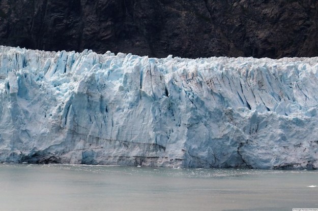
The highlight of our time in Glacier Bay was seeing Margerie Glacier which is about one mile wide with an ice face that is about 250 feet high over the water and with a base about 100 feet below sea level. IMG_2421IMG_2492IMG_20180626133857DSC_0657

The ship spent an hour at this one spot, giving everyone plenty of time to see Margerie. We were even able to see the glacier calving! See/select the below video:

https://www.youtube.com/watch?v=UDuANpJUhOo

Instead of words, the best way to show you Glacier Bay National Park is through pictures. And thanks once again to Beth for sharing her pictures! IMG_2463IMG_20180626_133829IMG_2477IMG_2446

See/select the below video:

https://www.youtube.com/watch?v=XQSRkI7nl-s

Train Ride to Seward, AK June 24, 2018

Sunday morning we returned the rental car to the Anchorage airport and met up with representatives of Holland America for our week long cruise from Alaska to Vancouver, British Columbia. But first we had to take a bus from the airport to the train station. Along the way we passed the Alaska Statehood Monument which marks President Eisenhower’s signing of Alaska as the 49th state on January 3, 1959. 20180624_115247

From the train station we took a train to Seward to board our cruise ship, the Noordam. IMG_20180624_122150

This blog will describe our five hour train ride through the beautiful Alaska countryside and Chugach National Forest. We had driven from Anchorage to Seward by car our first day in Alaska a week earlier see Seward, Alaska June 17, 2018. But seeing it by train felt entirely different, and much more relaxing than driving. Even better, Bill’s college friend Peter and his wife Beth had flown in from Florida to join us for the cruise. The train was comfortable with a table where the four of us could sit together and chat. IMG_2252DSCN6253

I will let pictures describe the train ride. Some of these pictures are courtesy of Beth. Many thanks Beth for sharing your pictures and allowing us to use them in the blog! 

IMG_2264

An Icefield or Glacier

IMG_2309

The Glaciers are Getting Closer

DSC_0472DSC_0516

IMG_2273

The Eagle’s Nest

IMG_2284

A Zoomed View of a Pretty Glacier

IMG_2288

The Train Followed This River

IMG_2299

Another Pretty Glacier

IMG_2304

The Train Went Through Several Tunnels and Here we Circled Back Over Our Own Tracks

DSC_0521

This is a Pedestrian Bridge Built For Hikers to Go To The Glacier

DSC_0535

Our Train Comes Into View on the Many Curves

IMG_2269DSC_0498DSC_0499DSC_0549DSC_0551DSCN6262

IMG_2326

This Is a School For Training Pilots to Land on Water

About 5:30 pm we arrived in Seward and boarded the ship for this second half of our exciting Alaska adventure. 

PANO_20180624_194639

Panoramic View of Seward Waterfront and Mountain Range

DSC_0557
DSC_0559r

IMG_2327

Our First Glacier We See As We Sail South

Along the road to Anchorage June 23, 2018

At the end of the last blog we were still on a quest to see Denali mountain, and things were not looking good with cloudy overcast skies. As we drove towards Anchorage we stopped at several overlooks hoping for a glance.

IMG_2197

One View Along the Parks Highway Driving South to Anchorage

This picture was taken at an overlook about 42 miles from Denali and still no luck. It was amazing to see the number of people at each overlook hoping to see that elusive mountain. After all, it is one of the iconic symbols of Alaska. IMG_2228IMG_2237

20180623_110454

Denali Mountain is Growing 3/4 Inches a Year because of Tectonic Plates!

We gave up and continued on our way. Suddenly Bill looked in the rear view mirror and said, “There it is!” We made a U turn and stopped on the side of the road for pictures.  The clouds had lifted enough for this view about 50 miles from Denali. Amazing how excited two people could get over seeing a mountain!! IMG_2245

Along the way to Anchorage we stopped at the Alaska Veterans Memorial. A beautiful memorial in a lovely peaceful setting along the road. IMG_2217IMG_2214IMG_2216

We arrived in Anchorage, the largest city in Anchorage and home to about half of Alaska’s population. It was established in 1915 as the headquarters for the construction of the Alaska Railroad. The downtown area was destroyed in 1964 by the Good Friday earthquake.

Unfortunately there wasn’t much time to explore the city. I had to do laundry at the hotel before the second half of our Alaska adventure starting tomorrow!

Next up: A bus, a train and a ship

Denali National Park June 21, 2018

Denali National Park and Preserve in Alaska, established in 1917, was high on our bucket list for this year.  Dall sheep are the symbol of the park because over-hunting of the sheep and efforts to save them is the reason the park was established.  Hunters were entering the park in large numbers to hunt game to feed gold miners and railroad workers. The park is six million acres of snow-capped peaks, multicolored tundra, clear lakes and rivers, alpine meadows and a multitude of wildlife. The crown jewel of the park is the 20,310 foot peak called Denali, the highest peak in North America. The peak has certainly undergone an identity crisis. It was named Denali in the Native American Athabascan language and means The Great One” or “The High One”.  IMG_2075

President McKinley, 25th President of the U.S. was assassinated in 1901. The park and mountain were named McKinley in his honor. In 1975 an effort was undertaken by the Alaska Board of Geographic Names to change the name back to Denali which is the name preferred by Alaskans.  The effort was blocked by representatives from McKinley’s home state of Ohio. In 1980 President Carter named it the Denali National Park and Preserve and increased the size from two million to six million acres. However he kept the name Mount McKinley.  In 2015 President Obama changed the name of the mountain back to Mount Denali. When talking of the peak today, most people simply say Denali.

With our excitement mounting we left Fairbanks and made the three hour drive to Denali National Park and Preserve.  It also happened to be June 21st, the longest day of the year, meaning we would have about 22 hours of daylight. Even once the sun set, it never got dark enough for streetlights to come on. 20180621_091812

We headed straight to the Visitors Center to check it out and see the movie. IMG_20180621_13471420180621_123232 Denali is not the easiest park to visit. In an effort to preserve the park wilderness as well as the wildlife, private vehicles are only allowed into the first 15 miles of the park or you can take a free park shuttle to this point. If you want to see anymore of the park you have to pay a rather large sum to take a Wilderness Tour. The first day we drove the 15 miles allowed, stopping at various viewpoints and hiking trails.  On the way out of the  park we saw a moose eating leaves from a tree. IMG_2082IMG_2085IMG_2078

We booked several months in advance the Tundra Wilderness Tour so the next day we had to be at the park by 6:30 A.M.  The tour was on a school bus and lasted for 8 hours. There is no food service in that area of the park so we had to take snacks and drinks.  Every 90 minutes we would take a bathroom break and stretch our legs. IMG_2106

There were no flush toilets during the day. Eight hours on a school bus and no flush toilets sounds miserable doesn’t it?  Actually we had a great day and really enjoyed it. We had an entertaining bus driver/guide. Everyone on the bus kept an eye out for wildlife. The bus was equipped with TV monitors.  IMG_2105When wildlife was spotted the driver stopped, and using a camcorder was able to zero in on the wildlife and display it on the TV monitors.  What a tremendous improvement over tours where animals are so far away they look like tiny dots. We saw fox clubs playing, a full grown fox, IMG_2144

many caribou  IMG_2117IMG_2125

IMG_20180622_111506

Caribou photographed from our TV monitor

IMG_2134

Caribou photographed from our TV monitor

 and jackrabbits, moose, many eagles, dall sheep,   

IMG_20180622_114606

Dall sheep photographed on our TV monitor

IMG_2090

This young fox or pup was photographed from our TV monitor

IMG_2096

These ravens appear to having a noisy argument

and towards the end of the day a grizzly bear and her two cubs (probably two years old). IMG_20180622_125138IMG_20180622_125156IMG_2160IMG_2178IMG_2181IMG_2188IMG_2222IMG_20180622_144318

At times the bus ride was scary as we traveled on narrow winding roads at the top of cliffs and had to pass other buses.  We couldn’t take a very good picture to show how scary it was but I found this postcard which shows the road and bus. IMG_2153IMG_2223

We stopped at the Toklat rest stop where there was a National Geographic Outpost.  Bill held caribou antlers on his head. He is such a good sport when I ask him to do things for pictures to entertain you! IMG_20180622_100455IMG_2121IMG_2132

We really really wanted to see the elusive Denali mountain.  Because of the location of the Alaska Range which gets cold, dry air from the north and warm, moist air from the ocean from the south, the two systems collide and cause clouds.  Denali is so high it is often hidden in the clouds. Less than 30% of people actually see Denali. The gift shops even have a T shirt that says something like “I am one of the 30%”.  Unfortunately the chances of seeing it decreases in the summer which is high tourist season. IMG_2102

So did we see it you are probably asking?  Not the first day and not the second day, not even during the Wilderness Tour.  At one point our bus driver looked in his rear view mirror and said he got a peek of the top.  He stopped the bus and everyone scrambled for their cameras. IMG_2191By this time the clouds had covered it again.

The next day we checked out of our hotel and turned the car towards Anchorage.  We still had not seen Denali. The day was cloudy and overcast. We were very disappointed.  Does the Denali story end there? Stay tuned for the next blog.

interesting Facts:

  • By area, Alaska has more than fifty percent of the national parkland in the United States.
  • More than 600,000 people visited the park in 2016, about 30% of visitors to Alaska.  Of the 600,000 visitors, about 59% of them take the bus trip deep into the park.
  • Archeological evidence shows people have lived in this region for over 13,000 years, migrating from Asia over the Bering Strait.   No permanent settlement sites have been found in Denali. For this reason it is believed the area was used for seasonal hunting only.
  • One sixth of Denali’s six million acres is covered by glaciers.  Most of Denali’s glaciers have receded in length and thickness over the past 60 years.
  • Today, America has almost 110 million acres of designated wilderness.
  • More than a thousand climbers attempt to climb Denali each year in April and May when high pressure systems keep storms away and before warmer temperatures causes the threat of avalanches to make it unsafe.  In good weather up to two thirds reach the top. During stormy or less than ideal conditions, only 40% make it.
  • Denali has been described as the “coldest mountain in the world” with record temperatures of -60 degrees F, wind gusts of 100 miles per hour, and wind chills down to -100 degrees F. Only one day in three is storm free.  Most of the world’s high mountains lie at lower latitudes. Denali is just 200 miles below the Arctic Circle. Even though Denali is not as high as Everest or Aconcagua, some say Denali is the hardest mountain to climb because of the Arctic conditions.
  • Alaska has warmed by three degrees F in the last 60 years.  Photos from the 1900’s show areas of open tundra.  Today they are now thick with shrubs and young spruce trees.  If this continues it is estimated the area may become a forest.

Fairbanks, Alaska June 20,2008

After busy days with long drives, we welcomed our two night stay in Fairbanks. Located near the geographic center of Alaska and in a lowland, the climate is very different and there are no snow covered mountains in view. While we were there the daytime highs were in the low 80’s and we were hot in the clothing we had packed. During this time of year Fairbanks has almost 24 hours of daylight. Fairbanks was once a gold rush and then a pipeline boom town, so it is called the “Golden Heart of Alaska “.  Today it is Alaska’s second largest city after Anchorage.  20180620_152551IMG_20180620_150905

Fairbanks is the farthest north from the equator we have ever traveled. We traveled North to 65°03’15.7″N 147°25’33.2″W or 4,500 miles from the equator for a few geocaches.

In 1902 gold was found in Fairbanks. A trading post was built and the gold rush began. Today there are still operating gold mines here. Panning for gold is a popular tourist activity. The area mines have world class mineral deposits as well as gold.

Today the economic base of Fairbanks comes from the Pipeline, military bases, mining and the University of Alaska, the country’s northernmost University. Fairbanks is the midpoint of the 800 mile Pipeline. Here is a picture of the “pig” which flows through the pipeline to clean it, much like a pipe cleaner. IMG_2065IMG_2063IMG_2062

While in Fairbanks we visited Pioneer Park where we saw the Golden Spike Train. President Warren G. Harding used this railroad car when he came to Alaska in the summer of 1923 to drive the golden spike signaling the completion of the Alaska Railroad from Fairbanks to Seward. Harding died in San Francisco before he could return to Washington, DC. 20180620_201332IMG_20180620_201356

A steam wheeler boat was in the middle of the Pioneer Park. IMG_20180620_201450

We saw two statues at the park to honor pioneers. 20180620_201923-EFFECTS20180620_202219

One evening we ate dinner at a restaurant along the Chena River and saw kayaker enjoying the water on this long day of sunlight. IMG_20180620_193334IMG_20180620_193321

After dinner we visited Antler Arch downtown.  It reminded us of the similar ones in Jackson Hole Wyoming. IMG_20180620_195910IMG_20180620_195830

Several Alaskans warned us earlier in the week that there wasn’t much to see or do in Fairbanks and it wasn’t very pretty. We would agree it is certainly not picturesque compared to most other Alaska towns. But when you think of Alaska, one of the places you think of is Fairbanks, so we had to go and check it out!  And we learned that the mosquitoes in Alaska are as fierce as everyone says,  We can see why people joke they are the state bird!

Alaska facts:

  • Alaska does not have counties, it has boroughs.
  • Alaska has 3 million lakes, 3,000 rivers, 1,800 Islands, 100,000 glaciers and 586,000 square miles of untamed wilderness. And don’t forget about nine national parks and preserves and two huge national forests with 66 million acres of undisturbed land.
  • Alaska is nicknamed “The Last Frontier” and “Land of the Midnight Sun”. The name Alaska comes from the Native American word “Alyeska” which means the Great Land.
  • The distances from Fairbanks to London is 1,100 miles closer than Fairbanks to Miami because of the curvature of the earth. 20180620_15014820180620_150208
  • The Trans-Alaska Pipeline can withstand earthquakes up to 8.5 on the Richter scale and temperatures as low as minus 80 F.
  • Alaska has one of the largest populations of bald eagles in the world.
  • In a deal nicknamed “Seward’s Folly”, Secretary of State William Seward bought Alaska from Russia for two cents per acre in 1867.
  • In 1880 gold and huge deposits of precious metals are discovered in Juneau and other places in Alaska.
  • Alaska governor Sarah Palin is first Republican woman to be on a presidential ticket with John McCain.

Valdez to Fairbanks, AK July 19, 2018

Day three in Alaska began the same way, with rain. And just like the day before, the weather quickly improved and it became a magnificent day.

After breakfast we found a geocache along the picturesque Valdez Harbor located on Prince William Sound and at the foot of the Chugach Mountains. We set out on another long drive from Valdez to Fairbanks. Three hundred and sixty-three miles to be exact. Another long but fun filled day. By the way, we used the famous and invaluable Alaska travel planner/guide called “The Milepost” constantly during our travels. We highly recommend it to anyone planning a trip to Alaska.

We set off once again on the Richardson Highway, and headed up and over Thompson Pass.  As we crossed we could see the tall snow poles which snowplows use as guides. They were as tall as light poles!  Fortunately this time we crossed without the fog. Along the way we passed many gorgeous waterfalls such as Bridal Veil and Horsetail Falls as we drove through Keystone Canyon. We can see why this area is nicknamed “The Land of Waterfalls “.  The road is also known as “The Adventure Corridor “.

Bridal Veil Falls drops 600 feet and Horsetail Falls is 330 feet. They were two of our favorite. IMG_1969IMG_1972IMG_1973IMG_197620180619_103734

Our next stop was at Worthington Glacier where we walked on a short paved trail to view the glacier. IMG_1980IMG_1983

We continued on to Wrangell-St. Elias National Park and Preserve. This park has the country’s largest glacial field and at 13.2 million acres is our largest national park.  Yes, larger than Denali or Yellowstone! In fact it would hold SIX Yellowstone parks! It holds nine of the 16 tallest peaks in the United States. Much of the park is wild, isolated and inaccessible by road so is best viewed by boat or air. It wasn’t established as a national park until 1980.  With a long drive ahead we stopped at the Visitors Center and saw their movie about the park and continued on. IMG_2008

We had great views of the Trans-Alaska pipeline from Valdez to Fairbanks. Oil was discovered in Prudhoe Bay, Alaska in 1968 and by 1977 the Pipeline had been laid. The pipeline carries oil 800 miles from Prudhoe Bay on the Arctic Ocean to the pipeline terminus at Port Valdez. We stopped at several viewing areas with informational boards during our drive.  We were surprised at how the pipeline snaked along, sometimes on the right, sometime on the left, sometime above ground and sometimes below. This mainly depends on soil conditions. Where the warm oil would cause the icy soil to thaw and erode, the pipeline is above ground. If the frozen ground is mostly well-drained gravel or solid rock and thawing is not a problem, the pipeline is underground. The zigzag pattern often seen, as well as Teflon coated crossbeams, allows for pipe expansion or contraction due to temperature changes or movement caused by such things as earthquakes. The pipeline has an earthquake detection system where ground accelerometers at pump stations measure earth movement. There are computers to identify and check important supports, valves and other such items after an earthquake.  The pipeline design was tested in November, 2002 by a large 7.9 earthquake. Today the Pipeline carries less oil but over the last 40 years has transported over 17 billion barrels of crude oil to Valdez. Oil output peaked in 1988 at two million barrels of oil per day. At this rate it took 4.5 days for the oil to travel from one end to another. After the Pipeline was completed in 1977, some workers settled in small towns around the state and the population grew. The infrastructure created by the Pipeline has had a lasting economic impact, especially due to the taxes levied on oil allowing the state of Alaska to increase spending on various needs. IMG_1995IMG_1991IMG_1993IMG_2000IMG_2001IMG_2002IMG_2012IMG_2016IMG_2031IMG_2032IMG_2035

As the day wore on we began to bemoan the fact that in our travels we had not seen any wildlife. Lo and behold shortly after that conversation, up ahead on the side of the road was a moose. Just casually sauntering along the roadway. We slowed down and he looked over at us as if to ask, “What are you looking at? “ I bet he was thinking, “Gee, more crazy tourists! “ IMG_2020IMG_2023IMG_2026IMG_2027IMG_2027

Delta Junction Visitor Center was a nice rest break for us later in the afternoon. This is the official end of the Alaska Highway. The Alaska Highway was finished during WW II  and begins in Dawson Creek, British Columbia and end 1,422 miles later in Delta Junction. In the early 1940’s soldiers built the road in below zero temperatures in winter and muddy conditions in the summer. Many African American troops worked on building the road. IMG_2040IMG_2039

Next was another view of the pipeline. This 1200 foot long section is suspended across the Tanana River between two towers. This is the second longest of 13 major bridges along the 800 mile length. IMG_2044

We also passed Eielson Air Force Base but they had signs along the highway prohibiting the taking of photographs. I did read in The Milepost that the runway there is 14,507 feet to accommodate B-36 aircraft and is the second longest runway in North America.

Our last stop of the day before reaching Fairbanks was at the town of North Pole (pop 2,117). Not THE North Pole but just a town. Supposedly the town was named North Pole in the hopes it would attract tourism and perhaps a toy manufacturer. It didn’t work. We stopped there for a quick dinner at a fast food restaurant where it appeared they had a large group of teenagers hanging out looking for trouble. I blame in part the restaurant manager who could control such behavior if he cared or tried. Anyway, all the light poles are decorated like candy canes. We took a picture of Santa Claus at Santa’s House. It would have been fun to stop by the post office and have something postmarked North Pole. I didn’t think about it at the time. Frankly the town with the candy cane light poles and street names like Rudolph, Santa Claus Lane and St Nicholas Drive seemed tacky and overdone. Anything for tourism and a buck. IMG_2046IMG_2047IMG_2048IMG_2051

We ended the day pulling into the hotel after another 12 hour day. Really tired and really happy with everything we had seen today. As we thought about the day, we reflected on the roads we easily traveled today and the conditions workers encountered as they built those roads over glaciers, icefields and danger of avalanches in sub zero weather and much less than ideal conditions.

Next up: Two days in Fairbanks

Valdez, Alaska June 18, 2018

On our second day in Alaska we woke up in Seward to the sound of rain. It was not an encouraging sign for our long drive from Seward to Valdez. We got dressed, had breakfast, loaded the car and headed out. We had an eight hour drive ahead of us, not counting stops for breaks, eating and sightseeing. Since we wanted to cram as much of Alaska into our time here as possible, and with two drivers it was doable.

We started back up the Seward Highway which is both an All-America Road and a National Scenic Byway. It is easy to see why. Driving back towards Anchorage we passed through tiny towns with names such as Moose Pass. We passed many signs warning to watch for moose but to our disappointment we never saw any wildlife.

The further we got from Seward the better the weather became so as we approached Anchorage the sky was clearing and the sun was peeking through. To our relief it looked like the weather was on our side. We stopped for lunch at an overpriced restaurant. By day two we realized all the food in Alaska is expensive. Groceries as well as restaurant food is much more costly than we are used to paying in the lower 48.

We turned onto the Glenn Highway and the further we drove the more beautiful the scenery became. This highway is also designated as a National Scenic Byway.  IMG_1943IMG_1909IMG_1911IMG_1914IMG_1907

We stopped at the Matanuska Glacier and State Recreation Site for a view of the Matanuska Glacier. It is so hard to capture the beauty in pictures! This glacier is the largest road accessible glacier in North America. It is four miles wide and extends for many miles back into the Chugach Mountains.  IMG_192520180618_161609

We passed over Eureka Summit, elevation 3,322 ft, the highest point on the Glenn Highway. Here we had unobstructed views of the Chugach Mountains, the tallest coastal mountains in North America. IMG_1919IMG_1916

We saw the Tazlina Glacier at Tazlina Lake and many of the hundreds of glaciers, large and small found in this area of Alaska. It is hard to look up and not see a glacier!  IMG_1937

As we approached our turn south to Valdez the Wrangell Mountains appeared.  IMG_1952IMG_1953IMG_1955

It was getting late afternoon by the time we turned off Glenn Highway onto Richardson Highway, the last leg of our drive to Valdez. Richardson Highway was the first road built in Alaska and ties together many different highways.  IMG_1957

It was hard to believe possible but the scenery became even more amazing with waterfalls after waterfalls cascading down from the mountains. Between the spring thaw and the recent rainfall, they were gorgeous. But along with the beauty came increasing clouds and the threat of more rain. Along the way we had our first glimpse of the great Alaskan Pipeline.  We will have more about the waterfalls and Pipeline in the next blog.

As we began the long climb up Thompson Pass, elevation 2,678 feet, the temperature dropped to 46 degrees and a heavy fog blanketed the summit.  In winter this pass averages fifty feet of snow and feeds the ice fields from which glaciers flow. We crept over the top and as we descended the fog began to clear as we dropped almost to sea level. It had been eleven hours since we left Seward and we were beginning to count the miles to Valdez.

As we entered Valdez (pop 4,000) the clouds again moved in and it became foggy with a light drizzle.  IMG_1961

Valdez is nicknamed “Switzerland of Alaska” because it is ringed by snow capped mountains. Like Seward, there really isn’t that much to do in Valdez unless you love to fish. Valdez is definitely more about the journey rather than the destination. After checking into the hotel we drove around the harbor but the fog definitely distracted from the beauty.  20180619_08195420180619_08190820180619_08201220180619_08015820180619_081826IMG_1967

Valdez was the jumping off point for the 1898 Alaska Gold Rush. Many residents arrived during the oil rush boom of the 1970’s and 1980’s but over the years the town has seen a decline in population. Since Valdez is the northernmost ice free port it is the end of the Alaska Pipeline.

Valdez has suffered two unfortunate events. On Good Friday, 1964, a 9.2 earthquake struck Alaska. It was the most powerful earthquake ever recorded in North America. Known as “The Great Alaska Earthquake, it killed 32 people in Valdez alone and the entire town was destroyed.  The town was then moved four miles from the end of the harbor to a safer location.

In 1989 Exxon Valdez dumped millions of gallons of crude oil into nearby Prince William Sound, the largest oil spill in North American history. Located just 25 miles from Valdez, the town became the center of clean up efforts.

Valdez is also known as the Snow Capital of Alaska. In the winter, with an average annual snowfall of 25 feet per year, houses can be buried up to their eaves in snow. It is usually early summer before the massive piles of snow heaped into mounds in the center of town is melted.

We were really tired so after looking around the town and eating dinner we fell into bed and fell asleep the minute our heads hit the pillows.

Next up: Waterfalls, the Alaska Pipeline and the drive to Fairbanks